Konkordiaplatz

Last updated
Aerial view of the Aletsch Glacier with the converging Jungfraufirn and Grosser Aletschfirn. Peaks of the Valais Alps on the horizon. Gletscherhorn aerial view.jpg
Aerial view of the Aletsch Glacier with the converging Jungfraufirn and Grosser Aletschfirn. Peaks of the Valais Alps on the horizon.
View from Konkordia towards Aletschhorn Aletschhorn from Konkordiaplatz.jpg
View from Konkordia towards Aletschhorn

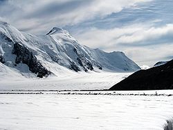
The Konkordiaplatz or Concordia Place (French: Place de la Concorde), is a flat area of snow and ice lying just to the south of the Jungfrau in the Bernese Alps in the Swiss canton of Valais. It is the junction of four large glaciers coming down from the Aletschfirn, the Jungfraufirn, the Ewigschneefäld and the Grüneggfirn. The main Aletsch Glacier originates from Konkordiaplatz. The Konkordiaplatz Charter was signed by the municipalities located in the Jungfrau-Aletsch Protected Area UNESCO World Heritage site, vowing to retain the aesthetic beauty of the region.

Contents

Naming

Concordia is the Latin word for harmony, literally "with (one) heart". It was the name of the Roman goddess of agreement, understanding, and marital harmony. British mountaineer John Frederick Hardy dubbed the location at the convergence of the several glaciers Place de la Concorde of Nature. [1]

The name Concordia was then given to other places where two or more glaciers meet, or large glaciated areas, such as Concordia in the Karakoram, [2] and Concordia Station in Antarctica.

Geography

Konkordiaplatz is located at an altitude between 2,700 and 2,800 metres, covering an area of approximately 2 km2. The depth of snow and ice is more than 900 metres. [3] It is surrounded by the Dreieckhorn (south), the Fiescher Gabelhorn (east), the Grünhorn (north-east) and the Kranzberg (subpeak of the Jungfrau) and Trugberg (north).

The area is uninhabited but the Konkordia Hut lies above the glacier, on the western slope of Gross Wannenhorn.

Related Research Articles

<span class="mw-page-title-main">Swiss Alps</span> Portion of the Alps that lies within Switzerland

The Alpine region of Switzerland, conventionally referred to as the Swiss Alps, represents a major natural feature of the country and is, along with the Swiss Plateau and the Swiss portion of the Jura Mountains, one of its three main physiographic regions. The Swiss Alps extend over both the Western Alps and the Eastern Alps, encompassing an area sometimes called Central Alps. While the northern ranges from the Bernese Alps to the Appenzell Alps are entirely in Switzerland, the southern ranges from the Mont Blanc massif to the Bernina massif are shared with other countries such as France, Italy, Austria and Liechtenstein.

<span class="mw-page-title-main">Bernese Alps</span> Part of the Alps mountain range in Switzerland

The Bernese Alps are a mountain range of the Alps, located in western Switzerland. Although the name suggests that they are located in the Berner Oberland region of the canton of Bern, portions of the Bernese Alps are in the adjacent cantons of Valais, Fribourg and Vaud, the latter being usually named Fribourg Alps and Vaud Alps respectively. The highest mountain in the range, the Finsteraarhorn, is also the highest point in the canton of Bern.

<span class="mw-page-title-main">Karakoram</span> Major mountain range spanning the borders between Pakistan and China

The Karakoram is a mountain range in Kashmir region spanning the borders of Pakistan, China, and India, with the northwest extremity of the range extending to Afghanistan and Tajikistan. Most of the Karakoram mountain range falls under the jurisdiction of Gilgit-Baltistan, which is controlled by Pakistan. Its highest peak, K2, is located in Gilgit-Baltistan. It begins in the Wakhan Corridor (Afghanistan) in the west, encompasses the majority of Gilgit-Baltistan, and extends into Ladakh and Aksai Chin. It is the second-highest mountain range in the world and part of the complex of ranges including the Pamir Mountains, the Hindu Kush and the Himalayan Mountains. The Karakoram has eighteen summits over 7,500 m (24,600 ft) in height, with four exceeding 8,000 m (26,000 ft): K2, the second-highest peak in the world at 8,611 m (28,251 ft), Gasherbrum I, Broad Peak and Gasherbrum II.

<span class="mw-page-title-main">Jungfrau</span> Mountain summit in the Bernese Alps, between the Swiss cantons of Bern and Valais

The Jungfrau, at 4,158 meters (13,642 ft) is one of the main summits of the Bernese Alps, located between the northern canton of Bern and the southern canton of Valais, halfway between Interlaken and Fiesch. Together with the Eiger and Mönch, the Jungfrau forms a massive wall of mountains overlooking the Bernese Oberland and the Swiss Plateau, one of the most distinctive sights of the Swiss Alps.

<span class="mw-page-title-main">Aletsch Glacier</span> Largest glacier in the Alps

The Aletsch Glacier or Great Aletsch Glacier is the largest glacier in the Alps. It has a length of about 23 km (14 mi) (2014), has about a volume of 15.4 km3 (3.7 cu mi) (2011), and covers about 81.7 km2 (2011) in the eastern Bernese Alps in the Swiss canton of Valais. The Aletsch Glacier is composed of four smaller glaciers converging at Konkordiaplatz, where its thickness was measured by the ETH to be still near 1 km (3,300 ft). It then continues towards the Rhône valley before giving birth to the Massa. The Aletsch Glacier is – like most glaciers in the world today – a retreating glacier. As of 2016, since 1980 it lost 1.3 kilometres (0.81 mi) of its length, since 1870 3.2 kilometres (2.0 mi), and lost also more than 300 metres (980 ft) of its thickness.

<span class="mw-page-title-main">Mer de Glace</span> Glacier located on the Mont Blanc massif, in the French Alps

The Mer de Glace is a valley glacier located on the northern slopes of the Mont Blanc massif, in the French Alps. It is 7.5 km long and 200 metres (660 ft) deep but, when all its tributary glaciers are taken into account, it can be regarded as the longest and largest glacier in France, and the second longest in the Alps after the Aletsch Glacier.

I can no otherwise convey to you an image of this body of ice, broken into irregular ridges and deep chasms than by comparing it to waves instantaneously frozen in the midst of a violent storm.

<span class="mw-page-title-main">Eiger</span> Mountain in the Bernese Alps, Switzerland

The Eiger is a 3,967-metre (13,015 ft) mountain of the Bernese Alps, overlooking Grindelwald and Lauterbrunnen in the Bernese Oberland of Switzerland, just north of the main watershed and border with Valais. It is the easternmost peak of a ridge crest that extends across the Mönch to the Jungfrau at 4,158 m (13,642 ft), constituting one of the most emblematic sights of the Swiss Alps. While the northern side of the mountain rises more than 3,000 m (10,000 ft) above the two valleys of Grindelwald and Lauterbrunnen, the southern side faces the large glaciers of the Jungfrau-Aletsch area, the most glaciated region in the Alps. The most notable feature of the Eiger is its nearly 1,800-metre-high (5,900 ft) north face of rock and ice, named Eiger-Nordwand, Eigerwand or just Nordwand, which is the biggest north face in the Alps. This huge face towers over the resort of Kleine Scheidegg at its base, on the eponymous pass connecting the two valleys.

<span class="mw-page-title-main">Finsteraarhorn</span> Mountain in the Bernese Alps

The Finsteraarhorn is a mountain lying on the border between the cantons of Bern and Valais. It is the highest mountain of the Bernese Alps and the most prominent peak of Switzerland. The Finsteraarhorn is the ninth-highest mountain and third-most prominent peak in the Alps. In 2001 the whole massif and surrounding glaciers were designated as part of the Jungfrau-Aletsch World Heritage Site.

<span class="mw-page-title-main">Mönch</span> Mountain in the Bernese Alps, in Switzerland

The Mönch at 4,110 metres (13,480 ft) is a mountain in the Bernese Alps, in Switzerland. Together with the Eiger and the Jungfrau, it forms a highly recognisable group of mountains, visible from far away.

<span class="mw-page-title-main">Jungfraujoch</span> Glacier saddle in the Swiss Alps

The Jungfraujoch is a saddle connecting two major 4000ers of the Bernese Alps: the Jungfrau and the Mönch. It lies at an elevation of 3,463 metres (11,362 ft) above sea level and is directly overlooked by the rocky prominence of the Sphinx. The Jungfraujoch is a glacier saddle, on the upper snows of the Aletsch Glacier, and part of the Jungfrau-Aletsch area, situated on the boundary between the cantons of Bern and Valais, halfway between Interlaken and Fiesch.

<span class="mw-page-title-main">Siachen Glacier</span> Glacier located in the eastern Karakoram range in the Himalayas

The Siachen Glacier is a glacier located in the eastern Karakoram range in the Himalayas at about 35.421226°N 77.109540°E, just northeast of the point NJ9842 where the Line of Control between India and Pakistan ends. At 76 km (47 mi) long, it is the longest glacier in the Karakoram and second-longest in the world's non-polar areas. It falls from an altitude of 5,753 m (18,875 ft) above sea level at its head at Indira Col on the India–China border down to 3,620 m (11,875 ft) at its terminus. The entire Siachen Glacier, with all major passes, has been under the administration of India as part of the union territory of Ladakh, located in the Kashmir region since 1984. Pakistan maintains a territorial claim over the Siachen Glacier and controls the region west of Saltoro Ridge, lying west of the glacier, with Pakistani posts located 3,000 ft below more than 100 Indian posts on the ridge.

<span class="mw-page-title-main">Aletschhorn</span> Mountain in the Bernese Alps

The Aletschhorn is a mountain in the Alps in Switzerland, lying within the Jungfrau-Aletsch region, which has been designated a World Heritage Site by UNESCO. The mountain shares part of its name with the Aletsch Glacier lying at its foot.

<span class="mw-page-title-main">Baltoro Glacier</span> Glacier in Pakistan

The Baltoro Glacier, at 63 km (39 mi) in length, is one of the longest glaciers outside the polar regions. It is located in the Shigar District of Gilgit-Baltistan in Pakistan, home to some of the world’s highest mountains. The glacier runs through the Karakoram mountain range, close to Chogori or K2, the highest mountain in the region at 8,611 meters. Three other nearby mountains within 20 kilometers are all above 8,000 meters as well.

<span class="mw-page-title-main">Biafo Glacier</span> Glacier in Pakistan

The Biafo Glacier is a 67 km (42 mi) long glacier situated in the Karakoram mountain range in Shigar district of Gilgit-Baltistan, Pakistan. One of the largest Karakoram glaciers, Biafo Glacier, flows south-east from the central Karakoram crest. Its basin covers an area of 853 km2, 628 km2 of which is permanent snow and ice, with the accumulation zone forming 68% of the glacier area.

<span class="mw-page-title-main">Eggishorn</span> Mountain in Switzerland

The Eggishorn is a mountain in the southeastern part of the Bernese Alps, located north of Fiesch in the Swiss canton of Valais. A cable car station is located on a secondary summit named Fiescherhorli, 500 metres south of the main peak.

<span class="mw-page-title-main">Jungfraujoch railway station</span>

Jungfraujoch is an underground railway station situated near the Jungfraujoch, in the canton of Valais, a few metres from the border with the canton of Bern. At 3,454 metres (11,332 ft) above sea level, it is the terminus of the Jungfrau Railway and the highest railway station in Switzerland and Europe. The Jungfrau Railway runs from Kleine Scheidegg in the Bernese Oberland, through the Jungfrau Tunnel and crosses the border between the two cantons shortly before the terminus.

<span class="mw-page-title-main">Konkordia Hut</span>

The Konkordia Hut is a mountain hut of the Swiss Alpine Club, located north of Fieschertal in the canton of Valais. The hut lies above Konkordiaplatz, the point of convergence of several glaciers in the great Aletsch Glacier system of the Bernese Alps. It is located at a height of 2,850 metres above sea level, at the foot of the Fülbärg.

<span class="mw-page-title-main">Mönchsjoch Hut</span>

The Mönchsjoch Hut is a mountain hut located in the Bernese Alps in the canton of Valais in Switzerland. At an altitude of 3,658 metres (12,001 ft) is one of the highest huts owned by the Swiss Alpine Club.

<span class="mw-page-title-main">Jungfrau-Aletsch protected area</span> Protected area in south-western Switzerland

The Jungfrau-Aletsch protected area is located in south-western Switzerland between the cantons of Berne and Valais. It is a mountainous region in the easternmost side of the Bernese Alps, containing the northern wall of Jungfrau and Eiger, and the largest glaciated area in western Eurasia, comprising the Aletsch Glacier. The Jungfrau-Aletsch protected area is the first World Natural Heritage site in the Alps; it was inscribed in 2001.

Indira Col West is a mountain pass at 5,988 metres (19,646 ft)) altitude on the Indira Ridge of Siachen Muztagh in Karakoram Range. It is on the border between Indian-controlled Siachen Glacier and the Chinese-controlled Trans-Karakoram Tract, close to the tripoint of India, Pakistan, and China. The India-Pakistan Actual Ground Position Line (AGPL) in the Siachen area ends near the pass. It is possible to ascend the pass from both the north and south sides controlled by China and India respectively.

References

  1. Some famous alpine ascents page 266
  2. William Martin Conway: Climbing and Exploration in the Karakoram Himalayas, S. 317. (Google-Books)
  3. Glacier d'Aletsch Archived 2009-06-21 at the Wayback Machine pronatura.ch (French)

Coordinates: 46°30′07″N8°02′08″E / 46.50194°N 8.03556°E / 46.50194; 8.03556