
Andhra Pradesh is a state in the southern coastal region of India. It is the seventh-largest state with an area of 162,970 km2 (62,920 sq mi) and the tenth-most populous state with 49,577,103 inhabitants. It has shared borders with Chhattisgarh, Odisha, Karnataka, Tamil Nadu, Telangana and the Bay of Bengal. It has the second-longest coastline in India at about 974 km (605 mi). After existence as Andhra State and unified Andhra Pradesh, the state took its present form on 2 June 2014, when the new state of Telangana was formed through bifurcation. Amaravati is the capital of the state, with the largest city being Visakhapatnam. Water sharing disputes and asset division with Telangana are not yet resolved. Telugu, one of the classical languages of India used by the majority of people, is the first official language.

Ongole is a city in Prakasam district of the Indian state of Andhra Pradesh. It is the headquarters of Prakasam district and also the mandal headquarters of Ongole mandal in Ongole revenue division. Ongole cattle, an indigenous breed of oxen, derived their name from Ongole.

The West Godavari district is a coastal district in the Indian state of Andhra Pradesh with an administrative headquarters in Bhimavaram. As of the 2011 Census of India, the district has an area of 2,178 km2 (841 sq mi) and a population of 1,779,935. It is bounded by the Krishna district and Bay of Bengal to the south, East Godavari district to the east, and Eluru district, Kolleru Lake and Upputeru Drain to the northwest.

Srikakulam district is one of the twenty-six districts of the Indian state of Andhra Pradesh, located in the Uttarandhra region of the state, with its headquarters located at Srikakulam. It is one of the six districts, located in the extreme northeastern direction of the state. It was formerly known as Chicacole, and was under Ganjam district till 1936 April 1, then merged under Vizagapatam district. Srikakulam district forms the core area of Kalinga where most of its historical capitals like Kalinganagari, pithunda, Dantapuram are located.

The Government of Andhra Pradesh, or Andhra Pradesh Government abbreviated as GoAP, is the State government for the Indian state of Andhra Pradesh. It is an elected government with 175 MLAs elected to the Legislative Assembly of Andhra Pradesh for a five-year term. The Government of Andhra Pradesh is a democratically elected body that governs the state of Andhra Pradesh, India. The state government is headed by the governor of Andhra Pradesh as the nominal head of state, with a democratically elected chief minister as the real head of the executive. The governor who is appointed for five years appoints the chief minister and his Council of Ministers. Even though the governor remains the ceremonial head of the state, the day-to-day running of the government is taken care of by the chief minister and his Council of Ministers in whom a great deal of legislative powers is vested.

The Andhra Pradesh Legislative Assembly or Āndhra Pradēś Śāsana Sabha is the lower house of the bicameral legislature of the Indian state, Andhra Pradesh.

Andhra Pradesh lies between 12°41' and 19.07°N latitude and 77° and 84°40'E longitude, and is bordered by Telangana to the north and west, Chhattisgarh to the north-west, Orissa to the north, the Bay of Bengal to the east, Tamil Nadu to the south and Karnataka to the southwest and west. Andhra Pradesh has a coastline of around 974 km, which gives it the second longest coastline in the nation. Two major rivers, the Godavari and the Krishna run across the state. A small enclave 12 sq mi (30 km²), the Yanam district of Puducherry, lies in the Godavari Delta in the north east of the state. The state includes the eastern part of Deccan plateau as well as a considerable part of the Eastern Ghats.

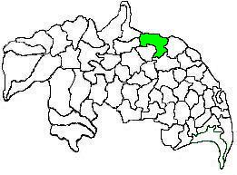
Gannavaram Assembly Constituency is a Scheduled Caste reserved constituency in Konaseema district of Andhra Pradesh that elects representatives to the Andhra Pradesh Legislative Assembly in India. It is one of the seven assembly segments of the Amalapuram Lok Sabha constituency.

Nellore Rural Assembly constituency is a constituency in Nellore district of Andhra Pradesh that elects representatives to the Andhra Pradesh Legislative Assembly in India. It is one of the seven assembly segments of the Nellore Lok Sabha constituency.

Mantralayam Assembly constituency is a constituency in Kurnool district of Andhra Pradesh that elects representatives to the Andhra Pradesh Legislative Assembly in India. It is one of the seven assembly segments of the Kurnool Lok Sabha constituency.

Duggirala mandal is one of the 18 mandals in Guntur district of the Indian state of Andhra Pradesh. It is under the administration of Tenali revenue division and the headquarters are located at Duggirala. The mandal is bounded by Mangalagiri, Pedakakani, Tenali and Kollipara mandals. Krishna River lies to the northeast of the Duggirala mandal.
Kollur mandal is one of the 25 mandals in Bapatla district of the Indian state of Andhra Pradesh. It is under the administration of Tenali revenue division and the headquarters are located at Kollur.
Amaravathi mandal is one of the 28 mandals in Palnadu district of the Indian state of Andhra Pradesh. It is under the administration of Sattenapalli revenue division and the headquarters are located at Amaravathi. The mandal is located on the banks of Krishna River, at a distance 27 km from the district headquarters. It is bounded by Atchampet, Krosuru, Pedakurapadu, Tadikonda and Thullur mandals.
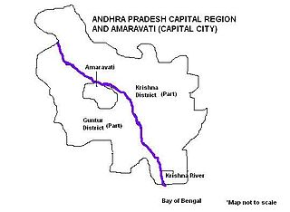
Andhra Pradesh Capital Region is the metropolitan area of the de facto capital city Amaravati of Andhra Pradesh in India. The region is spread across the districts of NTR, Krishna, Guntur, Palnadu, Bapatla and Eluru. It includes the major ancient cities of Vijayawada, Guntur and Tenali. Vijayawada is the largest city and headquarters of the region. It is one the most populated metropolitan areas in Andhra Pradesh. The region is under the jurisdiction of Andhra Pradesh Capital Region Development Authority and covers an area of 8,352.69 km2 (3,224.99 sq mi) under 58 mandals . The de facto capital city Amaravati is an urban notified area and will cover 217.23 km2 (83.87 sq mi), within the Andhra Pradesh Capital Region.

Thullur mandal is one of the 18 mandals in Guntur district of the Indian state of Andhra Pradesh. It is under the administration of Guntur Revenue Division and the headquarters are located at Thullur. The mandal is situated on the banks of Krishna River, bounded by Amaravathi, Tadikonda, Tadepalle and Mangalagiri mandals. The mandal is also a part of the new capital city of Andhra Pradesh to be developed. 18 villages from the mandal fall under the jurisdiction of Andhra Pradesh Capital City.
Vemuru mandal is one of the 25 mandals in Bapatla district of the state of Andhra Pradesh in India. It is under the administration of Tenali Revenue Division and the headquarters are located at Vemuru. The mandal is bounded by Tenali, Kollipara and Kollur, Amruthalur, Cherukupalle and Bhattiprolu mandals. The mandal is also a part of the Andhra Pradesh Capital Region under the jurisdiction of APCRDA.

Pedakakani mandal is one of the 18 mandals in Guntur district of the Indian state of Andhra Pradesh. It is under the administration of Guntur Revenue Division and the headquarters are located at Pedakakani. The mandal is bounded by Tadikonda, Mangalagiri, Duggirala, Tenali, Chebrole and Guntur mandals.

Amaravati is the capital of the Indian state of Andhra Pradesh. It is located on the right bank of the river Krishna in Guntur district.

The first case of the COVID-19 pandemic in the Indian state of Andhra Pradesh was reported in Nellore on 12 March 2020. A 24-year-old who was confirmed positive for coronavirus. He had travel history to Italy. The Andhra Pradesh Health department has confirmed a total of 5,37,687 cases, including 4,702 deaths and 4,35,467 recoveries, as of 10 September. The virus has spread in 13 districts of the state, of which East Godavari has the highest number of cases.