
Haymarket is a suburb of Sydney, New South Wales, Australia. It is located at the southern end of the Sydney central business district in the local government area of the City of Sydney. Haymarket includes much of Sydney's Chinatown, Thaitown and Railway Square localities. Haymarket is adjacent to Darling Harbour and is surrounded by the suburbs of Ultimo, Chippendale, Surry Hills and the Sydney CBD.
St Leonards is a suburb on the lower North Shore of Sydney, in the state of New South Wales, Australia. St Leonards is located 5 km north-west of the Sydney central business district and lies across the local government areas of Municipality of Lane Cove, North Sydney Council and the City of Willoughby.

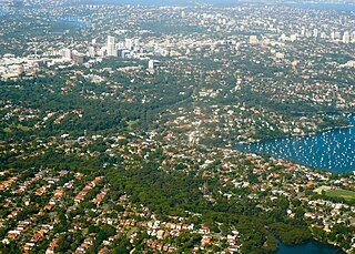
Chatswood is a major business and residential district in the Lower North Shore of Sydney, in the state of New South Wales, Australia, 10 kilometres north of the Sydney central business district. It is the administrative centre of the local government area of the City of Willoughby.
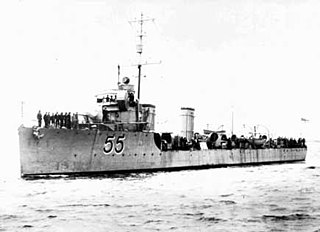
HMAS Parramatta, named after the Parramatta River, was a River-class torpedo-boat destroyer of the Royal Australian Navy (RAN). Ordered in 1909 for the Commonwealth Naval Forces, Parramatta was the first ship launched for the RAN. Temporarily commissioned into the Royal Navy for the delivery voyage to Australia, the destroyer came under Australian naval control in 1910, and was recommissioned into the RAN on 1 March 1911, shortly before the latter's formal creation.
Strathfield is a suburb in the Inner West of Sydney, in the state of New South Wales, Australia. It is located 12 kilometres west of the Sydney central business and is the administrative centre of Strathfield Council. A small section of the suburb north of the railway line lies within the City of Canada Bay, while the area east of The Boulevard lies within Burwood Council. North Strathfield and Strathfield South are separate suburbs to the north and south, respectively.

Burwood is a suburb in the Inner West of Sydney, in the state of New South Wales, Australia. It is 10 kilometres west of the Sydney central business district and is the administrative centre for the local government area of Burwood Council.
Zetland is an inner-eastern suburb of Sydney, New South Wales, Australia 4 kilometres south of the Sydney central business district, in the local government area of the City of Sydney.

Telopea is a suburb of Sydney, in the state of New South Wales, Australia. Telopea is located 23 kilometres north-west of the Sydney central business district, in the local government area of the City of Parramatta. The suburb is bordered by Kissing Point Road to the south and Pennant Hills Road to the north.

Silverwater is a suburb in western Sydney, in the state of New South Wales, Australia. Silverwater is located 20 kilometres west of the Sydney central business district on the southern bank of the Parramatta River within the local government area of City of Parramatta.

Roseville is a suburb on the Upper North Shore of Sydney in the state of New South Wales, Australia 12 kilometres (7.5 mi) north-west of the Sydney central business district, in the local government areas of Ku-ring-gai and Willoughby. Roseville Chase is a separate suburb to the east.

Campsie is a suburb in south-western Sydney, in the state of New South Wales, Australia. Campsie is 13 kilometres south-west of the Sydney central business district, on the southern bank of the Cooks River. Campsie is the large commercial and administrative centre of the Canterbury-Bankstown Council.

The Built Environment is a constituent body of the University of New South Wales, Australia. The school of architecture was one of the founding schools of UNSW. The Faculty of Architecture was established in 1950 and was one of the first three faculties of the university. In 1993 the name of the faculty was changed to the Faculty of the Built Environment.

HMAS Doomba was a Royal Australian Navy (RAN) warship of World War II. Built for the Royal Navy around the end of World War I as the Hunt-class minesweeper HMS Wexford, the ship only saw two years of service before she was decommissioned in 1921 and sold to the Doomba Shipping Company. The vessel was renamed SS Doomba, converted into a passenger ship, and operated in the waters around Brisbane until 1939, when she was requisitioned by the RAN for wartime service. Serving first as an auxiliary minehunter, then an auxiliary anti-submarine vessel, HMAS Doomba was purchased outright by the RAN in 1940, and served until early 1946, when she was sold and converted into a linseed oil lighter. Doomba was scuttled off Dee Why, New South Wales in 1976.

The Kokoda Track Memorial Walkway is a memorial walking track located in the suburb of Concord West, Sydney, New South Wales, Australia. It is located along the foreshore of shores of Brays Bay on the Parramatta River, and is a unique tribute to the Australian troops who fought in the World War II Papua-New Guinea campaign of July 1942 till January 1943.
Bankstown City Library and Information Service was a library service in Sydney. Bankstown situated in the south-west of Sydney, Australia. Part of Bankstown City Council, the library service includes the Central Library, located in Bankstown Central Business District, and four branch libraries Chester Hill, Greenacre, Padstow and Panania.

The International Convention Centre Sydney is an exhibition and convention centre which opened in December 2016, in Sydney, Australia. ICC Sydney is Australia's first and largest fully integrated convention, exhibition and entertainment centre. Created as a multipurpose event space, ICC Sydney has over 70 meeting rooms, three theatres and two formal ballrooms. It is capable of holding three entirely separate, self-sufficient, concurrent events.

The Glebe Town Hall is a landmark civic building in Glebe, a suburb of Sydney, Australia. It stands at 160 St Johns Road and was built in 1880 in the Victorian Italianate style by architect Ambrose Thornley. The Town Hall was the seat of The Glebe Municipal Council from 1880 to 1948 when it became a community centre and hall run by the City of Sydney. After being transferred to the Municipality of Leichhardt in 1968, it was returned to the control of the City of Sydney following a boundary change on 8 May 2003. The council commissioned extensive restoration works in 2008, which were completed in 2013, and the hall is now heritage listed on the Sydney Local Environmental Plan as "representative as the seat of local metropolitan government for Glebe Municipality, the fourth municipality to be incorporated under The Municipalities Act of 1858." It is also listed on the Register of the National Estate.

The Alexandria Town Hall is an Australian heritage-listed town hall located in Alexandria, a suburb of Sydney, New South Wales. It stands at 73 Garden Street. It was built in 1880–81 in the Victorian architectural style by Ferdinand Reuss Snr. Significant alterations which changed the facade to an Inter-War Free Classical style were completed in 1928 by architects D. T. Morrow and Gordon. The Town Hall was the seat of Alexandria Municipal Council from 1881 to 1948 and since 1948 has been a branch library, community centre and council depot for the City of Sydney and the South Sydney councils.
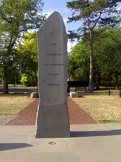
Military Memorials of National Significance meet a set of ten criteria laid down in the Military Memorials of National Significance Act of 2008 which received assent in the Australian Government on 12 Jul 2008. All such memorials are on public land within a State or the Northern Territory but outside the Australian Capital Territory. The Act allowed memorials outside Canberra to be recognised as National Memorials and the first to receive such recognition was the Australian Ex-Prisoners of War Memorial at Ballarat. The Member for Ballarat, Catherine King was instrumental in passing this legislation.


