Korija | |
|---|---|
Village | |
| Country | |
| County | |
| Town | Virovitica |
| Population (2011) [1] | |
| • Total | 767 |
| Time zone | UTC+1 (CET) |
| • Summer (DST) | UTC+2 (CEST) |
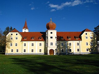
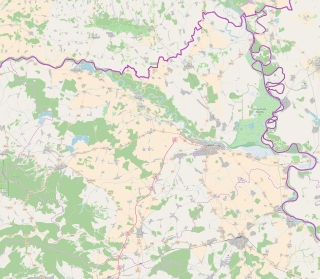
Korija is a village in Croatia. It is connected by the D2 highway.
Korija | |
|---|---|
Village | |
| Country | |
| County | |
| Town | Virovitica |
| Population (2011) [1] | |
| • Total | 767 |
| Time zone | UTC+1 (CET) |
| • Summer (DST) | UTC+2 (CEST) |
Korija is a village in Croatia. It is connected by the D2 highway.

Virovitica is a Croatian city near the Hungarian border. It is situated near the Drava river and belongs to the historic region of Slavonia. Virovitica has a population of 14,688, with 21,291 people in the municipality. It is also the capital of Virovitica-Podravina County.

Primorje-Gorski Kotar County is a county in western Croatia that includes the Bay of Kvarner, the surrounding Northern Croatian Littoral, and the mountainous region of Gorski kotar. Its center is Rijeka. The county's population was 296,195 at the 2011 census.

Virovitica-Podravina County is a northern Slavonian county in Croatia. Its county seat is in Virovitica and it includes the area around the Drava river, hence the name Podravina. Other notable towns are Slatina and Orahovica.

Požega-Slavonia County is a Croatian county in western Slavonia. Its capital is Požega. Its population was 78,034 as of the 2011 census.

Stara Gradiška is a village and a municipality in Slavonia, in the Brod-Posavina County of Croatia. It is located on the left bank of the river Sava, across from Gradiška in Bosnia and Herzegovina.

Kaptol is a village and a municipality in central Slavonia, Croatia. It is located on the slopes of Papuk mountain, east of Velika and northeast of Požega. The population of the municipality is 3,472, with 1,409 people in Kaptol itself, 97% are Croats.

Podsused – Vrapče is one of the districts of Zagreb, Croatia. It is located in the north-western part of the city. In 2011, the district had 45,759 inhabitants. Its area is 36.188 km2.

Krašić is a village and municipality in central Croatia, located near Jastrebarsko and Ozalj, south of Žumberak and north of Kupa, about 50 km southwest of Zagreb. Krašić comprises an area of about 3.63 km2. In the 2011 census, the total population was 2,640, in the following settlements:
Gornje Psarjevo is a village in central Croatia, located south of Sveti Ivan Zelina. The population is 311.

Kutjevo is a town in eastern Croatia. It is located in the Slavonia region, northeast of town of Požega.

Crnac is a village and municipality in Croatia in the Virovitica–Podravina County. It has a total population of 1,456, distributed in the following settlements:

Čačinci is a village and a municipality in Croatia in Virovitica-Podravina County. It has a population of 2,802, 91% of which are Croats. It is known for being very hot in the summer and very cold in the winter.

Garešnica is a town in Bjelovar-Bilogora County, Croatia. It is located in the geographical region of Moslavina. There are a total of 10,472 inhabitants, of whom 85% are Croats.

Dežanovac is a village and a municipality in Bjelovar-Bilogora County, Croatia. There are 2,715 inhabitants (2011). 58.9% of the population are Croats and 23.1% are Czechs.

Sirač is a settlement and municipality in Bjelovar-Bilogora County, Croatia. There are 2,218 inhabitants; 73% are Croats, 14% Serbs, and 11% Czechs. The following settlements make up the municipality: Barica, Bijela, Donji Borki, Gornji Borki, Kip, Miljanovac, Pakrani, Sirač, Šibovac.

Nova Kapela is a municipality in Brod-Posavina County, Croatia. There are 4,227 inhabitants in the following settlements:

Sibinj is a village and municipality in Brod-Posavina County, Croatia part of Slavonski Brod built-up area. There are 6,895 inhabitants; a majority are Croats according to the 2011 census.

Kloštar Podravski is a settlement and a municipality in the Koprivnica-Križevci County in Croatia. According to the 2011 census, there are 3,306 inhabitants in the area.

Vuka is a municipality in Osijek-Baranja County, Croatia. In the 2011 Croatian census there were 1,200 inhabitants, 97.17% of which were Croats.

Moštanica is a village in central Croatia, in the Town of Petrinja, Sisak-Moslavina County. It is connected by the D30 highway.
Coordinates: 45°51′24″N17°19′06″E / 45.8566500100°N 17.3183330100°E