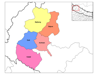
Kadel is a village in Bajhang District in the Seti Zone of north-western Nepal. At the time of the 1991 Nepal census it had a population of 3,816 and had 693 houses in the village.
Lekhgaun is a village in Bajhang District in the Seti Zone of north-western Nepal. At the time of the 1991 Nepal census it had a population of 3,346 and had 626 houses in the village.
Majhigaun is a village in Bajhang District in the Seti Zone of north-western Nepal. At the time of the 1991 Nepal census it had a population of 3,309 and had 622 houses in the village.
Bichhiya is a village in Bajura District in the Seti Zone of north-western Nepal. At the time of the 1991 Nepal census it had a population of 1,904 and had 352 houses in the village.
Jagannath, Nepal is a village in Bajura District in the Seti Zone of north-western Nepal. At the time of the 1991 Nepal census it had a population of 2,612 and had 538 houses in the village.
Sappata is a village in Bajura District in the Seti Zone of north-western Nepal. At the time of the 1991 Nepal census it had a population of 3,788 and had 662 houses in the village.

Kanda, Bajura is a village in Bajura District in the Seti Zone of north-western Nepal. At the time of the 1991 Nepal census it had a population of 2,741 and had 484 houses in the village.
Udayapur is a Village Development Committee in Banke District in the Bheri Zone of south-western Nepal. At the time of the 1991 Nepal census it had a population of 2,301 and had 397 houses in the village. Two government owned primary schools are situated here along with one among 10 Health Posts in district and a Police station. Now, it is a part of Nepalgunj sub-metropolitan city.
Tandrang is a Village Development Committee in Gorkha District in the Gandaki Zone of northern-central Nepal. At the time of the 1991 Nepal census it had a population of 4,368 and had 838 houses in the town.
Bachhanpurwa is a town and Village Development Committee in Bara District in the Narayani Zone of south-eastern Nepal. At the time of the 2011 Nepal census it had a population of 4,860 people living in 907 individual households. There were 2,284 males and 2,576 females at the time of census.
Bagadi is a village and Village Development Committee in Bara District in the Narayani Zone of south-eastern Nepal. At the time of the 2011 Nepal census it had a population of 3,491 people living in 451 individual households. There were 1,811 males and 1,680 females at the time of census.
Maheshpur is a town and Village Development Committee in Bara District in the Narayani Zone of south-eastern Nepal. At the time of the 1991 Nepal census it had a population of 3,621 persons residing in 640 individual households.
Laxmipur is a ward in the Ghorahi Sub Metropolitan which is located in Dang District in the Rapti Zone of south-western Nepal. At the time of the 1991 Nepal census it had a population of 9,075 persons residing in 1493 individual households.
Bharte is a village development committee in Lamjung District in the Gandaki Zone of northern-central Nepal. At the time of the 1991 Nepal census it had a population of 2591 people living in 544 individual households.
Kadamandau is a village development committee in Doti District in the Seti Zone of western Nepal. At the time of the 1991 Nepal census it had a population of 3084 living in 609 individual households.
Deurali, Tanahu is a village development committee in Tanahu District in the Gandaki Zone of central Nepal. At the time of the 1991 Nepal census it had a population of 2910 people living in 44 individual households.
Gagal Bhadaure is a village development committee in Ramechhap District in the Janakpur Zone of north-eastern Nepal. At the time of the 1991 Nepal census it had a population of 2596 people living in 468 individual households.
Siddheswar is a village development committee in Salyan District in the Rapti Zone of western-central Nepal. At the time of the 1991 Nepal census it had a population of 3715 people living in 604 individual households.
Timurekha is a village development committee in Palpa District in the Lumbini Zone of southern Nepal. At the time of the 1991 Nepal census it had a population of 2014 people living in 323 individual households.
Mashtanamdali is a former Village development committee in Achham District in the Seti Zone of western Nepal. At the time of the 1991 Nepal census, the village had a population of 1995 living in 350 houses. At the time of the 2001 Nepal census, the population was 2004, of which 31% was literate. Mashtanamdali now is part of Kamalbazar Municipality which was established in 2014.