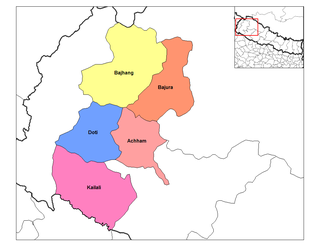
palakot wodapalika
The 1991 Nepal census was a widespread national census conducted by the Nepal Central Bureau of Statistics.

Banskharka is a village in Sindhupalchok District in the Bagmati Zone of central Nepal. At the time of the 1991 Nepal census it had a population of 2420 and had 517 houses in the village.It is also known for one of the famous house Dhukuti Ghar which was constructed by Dasrath Kachyapati following son Krishna Bhakta Kachyapati following son Ram Bhakta Kachyapati. And now all developmental works for that house and mailny for village is seen by Ram Bhakta's son Harigopal Kachyapati and he has been the pillar of the village.
Chaukati is a village in Sindhupalchok District in the Bagmati Zone of central Nepal. At the time of the 1991 Nepal census it had a population of 2346 and had 539 houses in the village.
Gumba, Nepal is a village in Sindhupalchok District in the Bagmati Zone of central Nepal. At the time of the 1991 Nepal census it had a population of 3107 and had 588 houses in the village.
Haibung is a village in Sindhupalchok District in the Bagmati Zone of central Nepal. At the time of the 1991 Nepal census it had a population of 2418 and had 489 houses in the village.
Piskar is a village in Sindhupalchok District in the Bagmati Zone of central Nepal. At the time of the 1991 Nepal census it had a population of 1870 and had 366 houses in the village.
Sipa Pokhare is a village in Sindhupalchok District in the Bagmati Zone of central Nepal. At the time of the 1991 Nepal census it had a population of 2515 and had 689 houses in the village.
Talamarang is a village in Sindhupalchok District in the Bagmati Zone of central Nepal. At the time of the 1991 Nepal census it had a population of 2880 and had 583 houses in the village.
Tekanpur, Nepal is a village in Sindhupalchok District in the Bagmati Zone of central Nepal. At the time of the 1991 Nepal census it had a population of 1714 and had 354 houses in the village.
Thangpal Dhap is a village in Sindhupalchok District in the Bagmati Zone of central Nepal. At the time of the 1991 Nepal census it had a population of 2994 and had 581 houses in the village.
Jorpati is a village and former Village Development Committee that is now part of Gokarneshwar Municipality in Kathmandu District in Province No. 3 of central Nepal. At the 2011 census it had a population of 84,567 making it one of the largest villages in the world. At the time of the 1991 Nepal census it had a population of 10,796 and had 1988 households in it.
Sangla is a village and former Village Development Committee that is now part of Tarakeshwar Municipality in Kathmandu District in Province No. 3 of central Nepal. At the time of the 1991 Nepal census it had a population of 2625 and had 515 households in it.
Satungal is a village and former Village Development Committee that is now part of Chandragiri Municipality in Kathmandu District in Province No. 3 of central Nepal. Satungal is also known as Satyapur. At the time of the 1991 Nepal census it had a population of 2730 and had 464 households in it. At the time of the 2001 Nepal census Satungal had a population of 5834 and had 1375 households in it. Satungal had 5173 literate people i.e. 88.66%..
Naubasta is a town in Banke District in the Bheri Zone of south-western Nepal. At the time of the 1991 Nepal census it had a population of 11,160 and had 1663 houses in the town.
Dolalghat is a village development committee in Kabhrepalanchok District in the Bagmati Zone of central Nepal.
Laxmipur is a former town and Village Development Committee in Ilam District in the Mechi Zone of eastern Nepal.
Pathari Sanischare (पथरी-शनिश्चरे) is a Municipality in Morang District in the Koshi Zone of south-eastern Nepal. It was formed by merging two existing village development committees i.e. Pathari and Sanischare in May 2014.
Nepal conducted a widespread national census in 2011 by the Nepal Central Bureau of Statistics. Working with the 58 municipalities and the 3915 Village Development Committees at a district level, they recorded data from all the municipalities and villages of each district. The data included statistics on population size, households, sex and age distribution, place of birth, residence characteristics, literacy, marital status, religion, language spoken, caste/ethnic group, economically active population, education, number of children, employment status, and occupation.

Sundar Haraicha is a municipality in Morang District of Province No. 1 in Nepal that was established on 10 March 2017 by merging the former municipalities Sundar Dulari and Koshi Haraicha. At the time of the 2011 Nepal census, the localities out of which Chaudandigadhi would be formed had a joint population of 80,518 people living in 18,610 individual households.