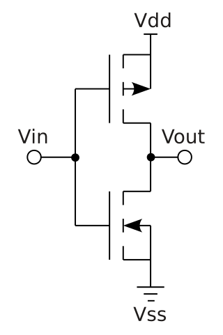
Complementary metal–oxide–semiconductor is a type of metal–oxide–semiconductor field-effect transistor (MOSFET) fabrication process that uses complementary and symmetrical pairs of p-type and n-type MOSFETs for logic functions. CMOS technology is used for constructing integrated circuit (IC) chips, including microprocessors, microcontrollers, memory chips, and other digital logic circuits. CMOS technology is also used for analog circuits such as image sensors, data converters, RF circuits, and highly integrated transceivers for many types of communication.

Mangalore, officially known as Mangaluru, is a major industrial port city in the Indian state of Karnataka and on the west coast of India. It is located between the Laccadive Sea and the Western Ghats about 352 km (219 mi) west of Bangalore, the state capital, 14 km north of Karnataka–Kerala border and 297 km south of Goa. Mangalore is the state's only city to have all four modes of transport—air, road, rail and sea. The population of the urban agglomeration was 619,664 according to the 2011 national census of India. It is known for being one of the locations of the Indian strategic petroleum reserves.
Dakshina Kannada district is located in the state of Karnataka in India, with its headquarters in the coastal city of Mangalore. It is part of the larger Tulu Nadu region. The district covers an area nestled in between the Western Ghats to its east and the Arabian Sea to its west. Dakshina Kannada receives abundant rainfall during the Indian monsoon. It is bordered by Udupi district to the north, Chikmagalur district to the northeast, Hassan district to the east, Kodagu to the southeast and Kasaragod district of Kerala to the south. According to the 2011 census of India, Dakshina Kannada district had a population of 2,083,625. It is the only district in Karnataka state to have all modes of transport like road, rail, water and air due to the presence of a major hub, Mangalore. This financial district is also known as the Cradle of Indian banking.
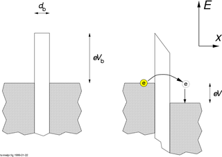
In mesoscopic physics, a Coulomb blockade (CB), named after Charles-Augustin de Coulomb's electrical force, is the decrease in electrical conductance at small bias voltages of a small electronic device comprising at least one low-capacitance tunnel junction. Because of the CB, the conductance of a device may not be constant at low bias voltages, but disappear for biases under a certain threshold, i.e. no current flows.
Kotekara is a census town in Dakshina Kannada district in the Indian state of Karnataka.Kotekar is located on NH-17 south of Mangalore towards Talapady.
Thokottu is a commercial junction to the south of Mangalore city on National Highway 66 and the gateway to Mangalore city from the South (Kerala). It is one of the major and busiest junctions of Mangalore city wherein one road goes towards east to Deralakatte and Konaje, educational hubs with several premium educational institutions and few information technology companies, the other road towards west goes to Ullal. This junction connects Mangalore city, second major city of Karnataka with Talapady and Kerala. A flyover is constructed in the junction to reduce the congestion for the travellers travelling between Mangalore city and Kerala. The creation of educational institutions in Deralakatte and Konaje has led to the construction of many commercial complexes in the area.
The word "Uchil" is from old Celtic language meaning "the high ground."
Kinnya or Kinya is a village in Dakshina Kannada district of Karnataka state, India. The ancient Kinya Jumma Masjid And Talapady Durga Parameshwari Temple is in this village. The village Kinnya lies near Arabian Sea Shared Border with Thalapady, Kotekar, Naringana And Manjanady Village. Total Population 6800, Native Language Beary, Malayalam And Tulu. It is located 23 km south of Mangalore city. In local Tulu language Kinya means small. The Durga Parameshwari Temple was recently renovated in the year 2015. Shree Durga Parameshwari temple is the family deity (Kuladevi) of many people who are the natives of undivided South Canara District. The village code is 02699400 as per Karnataka Administrative atlas 2001 published by DCO of Karnataka state. Pincode of Kinya village post office is 575023.
Sahana Kumari Nagaraj Gobbargumpi is an Indian athlete who competes in the high jump event. She holds the current national record of 1.92 m.
National Highway 66, commonly referred to as NH 66, is a mostly 4 lane 1640 km long busy National Highway that runs roughly north–south along the western coast of India, parallel to the Western Ghats. It connects Panvel to Cape Comorin (Kanyakumari), passing through the states of Maharashtra, Goa, Karnataka, Kerala and Tamil Nadu.

Kanipura Sri Gopalakrishna Temple at Kumbla is an ancient temple situated eight miles due north of the town of Kasaragod. The Krishnashila Idol of the Lord Bala Gopalkrishna had the features of a child and was worshipped by Lord Krishna's foster mother Yashoda. According to local religious beliefs, this idol was presented by the almighty Lord Krishna himself to the sage Kanva Maharshi in Dvapara Yuga, who in turn installed the idol at its present location where the temple still stands today. Historical records state that in the 10th-century, the Temple was renovated by King Jayasimha of the Kadamba dynasty, whose capital was Kumbla and even the administration of his Kingdom was being done in the name of Kanipura Sri Gopalkrishna. The coronation of Kumbla Rajas was being solemnized at Kanipura Sri Gopalkrishna Temple.

