
The Godavari is India's second longest river after the Ganga river and drains into the third largest basin in India, covering about 10% of India's total geographical area. Its source is in Trimbakeshwar, Nashik, Maharashtra. It flows east for 1,465 kilometres (910 mi), draining the states of Maharashtra (48.6%), Telangana (18.8%), Andhra Pradesh (4.5%), Chhattisgarh (10.9%) and Odisha (5.7%). The river ultimately empties into the Bay of Bengal through an extensive network of tributaries. Measuring up to 312,812 km2 (120,777 sq mi), it forms one of the largest river basins in the Indian subcontinent, with only the Ganga and Indus rivers having a larger drainage basin. In terms of length, catchment area and discharge, the Godavari is the largest in peninsular India, and had been dubbed as the Dakshina Ganga.

Dudh Koshi is a river in eastern Nepal. It is the highest river in terms of elevation.
The Tamor River is a major river in eastern Nepal, which begins around Kanchenjunga. The Tamor and the Arun join the Sun Koshi at Tribenighat to form the giant Saptakoshi which flows through Mahabharat Range on to the Gangetic plain
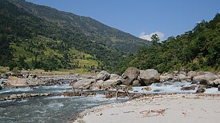
Indravati River is a tributary of the Godavari River, in central India.

The Godavari River has its catchment area in seven states of India: Maharashtra, Telangana, Chhattisgarh, Madhya Pradesh, Andhra Pradesh, Karnataka and Odisha. The number of dams constructed in Godavari basin is the highest among all the river basins in India. Nearly 350 major and medium dams and barrages had been constructed in the river basin by the year 2012.
Indravati National Park is a national park located in Bijapur district of Chhattisgarh state in India. The park derives its name from the Indravati River, which flows from east to west and forms the northern boundary of the reserve with the Indian state of Maharashtra.
Dantewada is a town and a municipality, or nagar palika. in the Dantewada district in the state of Chhattisgarh, India.It is the administrative headquarters of Dantewada District. It is the fourth largest city of Bastar division. The town is named after the goddess Danteshwari, the presiding deity of the Danteshwari Temple located in the town, 80 km from the Jagdalpur town. The goddess is worshipped as an incarnation of Shakti and the temple is held to be one of the fifty-two sacred Shakti Peethas. Dantewada Town is well connected by broad gauge railway line from Visakhapatnam. The Nearest Big city to Dantewada is Raipur and well connected with Bus services

The Central Provinces was a province of British India. It comprised British conquests from the Mughals and Marathas in central India, and covered parts of present-day Madhya Pradesh, Chhattisgarh and Maharashtra states. Nagpur was the primary winter capital while Pachmarhi served as the regular summer retreat. It became the Central Provinces and Berar in 1903.

The Arun River is a trans-boundary river and is part of the Kosi or Sapt Koshi river system in Nepal. It originates in Tibet Autonomous Region of the People's Republic of China where it is called the Phung Chu or Bum-chu.

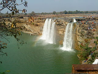
The Chitrakote Falls is a natural waterfall on the Indravati River, located approximately 38 kilometres (24 mi) to the west of Jagdalpur, in Bastar district in the Indian state of Chhattisgarh.
National Highway 63 is a National Highway in India, total length 860 km (530 mi). It passes through the states of Maharashtra, Telangana, Maharashtra, Chhattisgarh & Odisha.

Sabari River is one of the main tributaries of Godavari. It originates from the western slopes of Eastern Ghats in Odisha state from Sinkaram hill ranges at 1370 m MSL. It is also known as Kolab river in Odisha.The Sabari river basin receives nearly 1250 mm annual average rainfall. It forms common boundary between Chhattisgarh and Odisha states and later enters into Andhra Pradesh to merge with River Godavari. Upper Kolab project, located in Odisha across the Sabari is a major dam project supplying water for irrigation and Hydro power generation.

The Indravati River in Nepal is a tributary of the Sun Koshi River. It used to be called "Melamchi" or "Melamchu" until the 19th century.
The Barun River is a tributary of the Arun River and is part of the Kosi river system in Nepal.

The Sunkoshi, also spelt Sunkosi, is a river of Nepal that is part of the Koshi or Saptkoshi River system in Nepal. Sunkoshi has two source streams, one that arises within Nepal in Choukati, and the other more significant stream that flows in from Nyalam County in the Tibet region of China. The latter is called Bhote Koshi in Nepal and Matsang Tsangpo in Tibet. Due to the significant flows from Bhote Koshi, the Sun Koshi river basin is often regarded as a trans-border river basin.
The Pranahita Chevella Lift Irrigation Project is a lift irrigation project to harness the water of Pranhita tributary of Godavari river for use in the Telangana state of India. The river water diversion barrage across the Pranahita river is located at Thammidihatti village in Komaram Bheem district of Telangana. This lift canal is an inter river basin transfer link by feeding Godavari river water to Krishna river basin. The chief ministers of Telangana and Maharashtra states reached an agreement in 2016 to limit the full reservoir level (FRL) of the barrage at 148 m msl with 1.85 tmcft storage capacity. In the year 2016, this project is divided into two parts. The scheme with diversion canal from the Thammmidihatti barrage to connect to existing Yellampalli reservoir across the Godavari river is presently called Pranahita barrage lift irrigation project. This scheme is confined to providing irrigation facility to nearly 2,00,000 acres in Adilabad district using 44 tmcft water.
Koksara is one of the Town in Dharamgarh sub-division in Kalahandi District in Odisha State. This town and Gram Panchayat comes under Kokasara Tehsil in Kalahandi District. Kokasara is 57 km distance from its District Main City Bhawanipatna and 484 km distance from its State Main City Bhubaneswar. Smt Sabyarani Bag is the Chairperson of Koksara Block, Sri Tribhuban Naik is the PS member from Koksara GP and Sri Kishor Chandra Pradhani is the Sarapanch of Koksara Gram Panchyat.
The Chatra Gorge is a canyon cut by the Kosi River across the Mahabharat Range in Nepal.

The Government of India (GoI) constituted a common tribunal on 10 April 1969 to solve the river water utilization disputes about the river basin states of Godavari and Krishna rivers under the provisions of Interstate River Water Disputes Act – 1956. The common tribunal was headed by Sri RS Bachawat as its chairman with Sri DM Bhandari and Sri DM Sen as its members. Godavari river basin spreads through the states of Telangana (TS), Maharashtra (MR), Orissa, old Madhya Pradesh {later bifurcated into present Madhya Pradesh (MP) and Chhattisgarh}, Karnataka (K) and Andhra Pradesh (AP). Krishna river basin states Maharashtra, Karnataka and Andhra Pradesh insisted on the quicker verdict as it had become more expedient for the construction of irrigation projects in Krishna basin. So the of Godavari Water Disputes Tribunal (GWDT) could not proceed till the Krishna Water Disputes Tribunal final verdict was submitted to GoI on 27 May 1976.
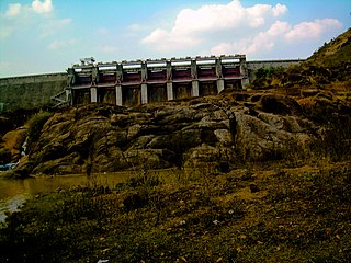
Indravati Dam is a gravity dam on the Indravati River a tributary of Godavari, about 90 km from Bhawanipatna in the state of Odisha in India. It is connected to the main Indravati reservoir via 4.32 km long and 7 m dia head race tunnel designed for a discharge capacity of 210 cumecs and terminating in a surge shaft. Currently it is the largest power producing dam in eastern India with a capacity of 600 MW.
