Shona is a Bantu language of the Shona people of Zimbabwe. The term is variously used to collectively describe all the Central Shonic varieties or specifically Standard Shona, a variety codified in the mid-20th century. Using the broader term, the language is spoken by over 14,000,000 people.
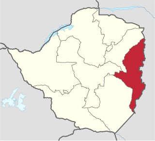
Manicaland is a province in eastern Zimbabwe. After Harare Province, it is the country's second-most populous province, with a population of 2.037 million, as of the 2022 census. After Harare and Bulawayo provinces, Manicaland is Zimbabwe's third-most densely populated province. Manicaland was one of five original provinces established in Southern Rhodesia in the early colonial period. The province endowed with country's major tourist attractions, the likes of Mutarazi Falls, Nyanga National Park and Zimbabwe's top three highest peaks. The province is divided into ten administrative subdivisions of seven rural districts and three towns/councils, including the provincial capital, Mutare. The name Manicaland is derived from one of the province's largest ethnic groups, the Manyika, who originate from the area north of the Manicaland province and as well as western Mozambique, who speak a distinct language called ChiManyika in Shona.

Masvingo, previously named Victoria, is a province in southeastern Zimbabwe. It has a population of 1.638 million as of the 2022 census, ranking fifth out of Zimbabwe's ten provinces. Established by the British South Africa Company, it was one of the five original provinces of Southern Rhodesia. In 1982, two years after Zimbabwean independence, it was renamed Masvingo Province. The province is divided into seven districts, including Masvingo District, which contains the provincial capital Masvingo City.

Mutare, formerly known as Umtali until 1982, is the most populous city in the province of Manicaland, and the third most populous in Zimbabwe, having surpassed Gweru in the 2012 census, with an urban population of 224,802 and approximately 260,567 in the surrounding districts, giving the wider metropolitan area a total population of over 500,000 people. Mutare is also the capital of Manicaland Province and the largest city in eastern Zimbabwe.
Chimurenga is a word in the Shona. The Ndebele equivalent is not as widely used since most Zimbabweans speak Shona; it is Umvukela, meaning "revolutionary struggle" or uprising. In specific historical terms, it also refers to the Ndebele and the Shona insurrections against administration of the British South Africa Company during the late 1890s, the First Chimurenga—and the war fought between African nationalist guerrillas and the predominantly-white Rhodesian government during the 1960s and the 1970s, the Rhodesian Bush War, or the Second Chimurenga/Imvukela.
The Manyika tribe is a Shona sub-group that originated from Manyika Dynasty. Manyika people speaks several dialects which include ChiManyika, ChiBocha, ChiUngwe, ChiHera, Chijindwi and the Urban dialect which is spoken in urban centers like Mutare and Rusape.
Chegutu, originally known as Hartley, is a town in Mashonaland West Province, Zimbabwe.
Marondera, originally known as Marandellas, is a city in Mashonaland East, Zimbabwe, located about 72 kilometres (45 mi) east of Harare.
Mutoko is a small town in Mashonaland East province, Zimbabwe. It was established as an administrative station in 1911. It lies 143 km from Harare. It is named after the local chief, Mutoko.

The military history of Zimbabwe chronicles a vast time period and complex events from the dawn of history until the present time. It covers invasions of native peoples of Africa, encroachment by Europeans, and civil conflict.
The Tonga people of Zambia and Zimbabwe are a Bantu ethnic group of southern Zambia and neighbouring northern Zimbabwe, and to a lesser extent, in Mozambique. They are related to the Batoka who are part of the Tokaleya people in the same area, but not to the Tonga people of Malawi. In southern Zambia they are patrons of the Kafue Twa. They differ culturally and linguistically from the Tsonga people of South Africa and southern Mozambique.

The following outline is provided as an overview of and topical guide to Zimbabwe:
Many languages are spoken, or historically have been spoken, in Zimbabwe. Since the adoption of its 2013 Constitution, Zimbabwe has 16 official languages, namely Chewa, Chibarwe, English, Kalanga, Koisan, Nambya, Ndau, Ndebele, Shangani, Shona, sign language, Sotho, Tonga, Tswana, Venda, Xhosa. The country's main languages are Shona, spoken by only 42% of the population, and Ndebele, spoken by roughly 39%. English is the country's lingua franca, used in government and business and as the main medium of instruction in schools. English is the first language of most white Zimbabweans, and is the second language of a majority of black Zimbabweans. Historically, a minority of white Zimbabweans spoke Afrikaans, Greek, Italian, Polish, and Portuguese, among other languages, while Gujarati and Hindi could be found amongst the country's Indian population. Deaf Zimbabweans commonly use one of several varieties of Zimbabwean Sign Language, with some using American Sign Language. Zimbabwean language data is based on estimates, as Zimbabwe has never conducted a census that enumerated people by language.

The A2 Highway is a primary road in Zimbabwe running from Harare to Nyamapanda at the border with Mozambique. The Mozambican side border post is called Cochemane. This is a busy entry point used by people travelling by road between South Africa, Malawi, Zimbabwe and Mozambique. It starts at intersection with Samora Machel Avenue; however Enterprise Road itself begins from the T-junction with Robert Mugabe Avenue, opposite the market in Eastlea, east of Simon Muzenda Street Road Port; a bus terminus for inter-regional buses.

The Avenues is an inner city suburb in Harare, Zimbabwe. Known for its diversity and mixed use activities, the Avenues contains together residential, commercial and entertainment areas, and has a vibrant nightlife with numerous cafes, bars and restaurants. It also holds a busy stretch of shops, retail businesses and office space. As a distinct, named area, the Avenues came into being in the late 1950s, during the Federation, when it drew together several smaller neighbourhoods that were first developed in the early 20th century.
Uzumba-Maramba-Pfungwe, also known as UMP, is a district of Mashonaland East Province in Zimbabwe. It consists of the northern part of the pre-1969 larger Murehwa (Mrehwa) District and includes the village of Uzumba. The area is inhabited by the Budja Shona people. The staple food crop is maize, with secondary vegetable crops.
Mutoko District is a district of Mashonaland East Province, Zimbabwe, in southern Africa. It is located in the eastern part of Zimbabwe, and covers 4,092.5 square kilometres (1,580 sq mi). In 2022, the district had a population of 161,091. At that time, nearly 50% of the population was under 19 years of age.
Mudzi District is a district of Mashonaland East Province, Zimbabwe, in southern Africa. It is located in the far eastern part of Zimbabwe, and covers 4,075 square kilometres (1,573 sq mi), all of which is communal land. As of the 2022 census, the district had a population of 158,478, this is up only slightly from the 135,378 of the 2002 census and reflects emigration due to the poverty of the district. It has a single main road, A2, that runs from the town of Mutoko in Mutoko District in the southwest through the district, past the villages of Chifamba, Mudzi, Chingwena, Masarakufa, Nyamuwanga, the town of Kotwa, and the village of Muzezuru to the town of Nyamapanda before entering Mozambique to the northeast.
Avonlea is a residential suburb in northwest Harare. It lies just in the west of Avondale southwest of Emerald Hill, southeast of Marlborough, and north of the greater Mabelreign area. Avonlea is home to approximately 15,600 people.
Milton Park is a densely populated, inner city, mixed use suburb just west of central Harare, Zimbabwe. Due to its density, diversity and character it is often compared to The Avenues, Belgravia, Greendale, Eastlea and Highlands. Separated from the CBD by the A1 highway east, is it is usually considered to be bounded to the south by Princes Road, to the north by Cork Road, to the west by Warren Hills Golf Club.
