
North Khorasan Province is a province located in northeastern Iran. Bojnord is the capital of the province. The counties of North Khorasan Province are Shirvan County, Esfarayen County, Maneh and Samalqan County, Raz and Jargalan County, Jajarm County, Faruj County, and Garmeh County. North Khorasan is one of the three provinces that were created after the division of Khorasan in 2004. In 2014 it was placed in Region 5.
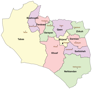
South Khorasan Province is a province located in eastern Iran. Birjand is the centre of the province. The other major cities are Ferdows, Tabas and Qaen. In 2014, it was placed in Region 5.

Razavi Khorasan Province is a province located in northeastern Iran. Mashhad is the center and capital of the province. Other cities are Quchan, Dargaz, Chenaran, Sarakhs, Fariman, Torbat-e Heydarieh, Torbat-e Jam, Taybad, Khaf, Roshtkhar, Kashmar, Bardaskan, Nishapur, Sabzevar, Gonabad, Kalat. The counties of Razavi Khorasan Province are Khalilabad County, Mahvelat County, Chenaran County, Dargaz County, Kalat County, Quchan County, Mashhad County, Sarakhs County, Nishapur County, Firuzeh County, Khoshab County, Jowayin County, Joghatai County, Davarzan County, Sabzevar County, Bardaskan County, Bajestan County, Kashmar County, Gonabad County, Khaf County, Roshtkhar County, Taybad County, Bakharz County, Zaveh County, Fariman County, Torbat-e Jam County, Torbat-e Heydarieh County & Torqabeh and Shandiz County. Razavi Khorasan is one of the three provinces that were created after the division of Khorasan Province in 2004. In 2014 it was placed in Region 5 with Mashhad as the location of the region's secretariat.

Khorasan, sometimes called Greater Khorasan, is a historical region lying in northeast of Greater Persia, including part of Central Asia and Afghanistan. The name simply means "East, Orient" and loosely includes the territory of the Sasanian Empire north-east of Persia proper. Early Islamic usage often regarded everywhere east of so-called Jibal or what was subsequently termed 'Iraq Ajami', as being included in a vast and loosely-defined region of Khorasan, which might even extend to the Indus Valley and Sindh. During the Islamic period, Khorasan along with Persian Iraq were two important territories. The boundary between these two was the region surrounding the cities of Gurgan and Qumis. In particular, the Ghaznavids, Seljuqs and Timurids divided their empires into Iraqi and Khorasani regions.

Abu Ismaïl Abdullah al-Herawi al-Ansari or Abdullah Ansari of Herat (1006–1088) also known as Pir-i Herat "Sage of Herat", was a Persian Sufi saint of Arab origin who lived in the 11th century in Herat. One of the outstanding figures in Khorasan in the 5th/11th century: commentator of the Qur'an, traditionist, polemicist, and spiritual master, known for his oratory and poetic talents in Arabic and Persian.
Abu Nazar Abdul Aziz ibn Mansur Asjadi was a 10th-century and 11th century royal Persian poet of Ghaznavid empire located in Ghazni province of current Afghanistan.

Aria is an Achaemenid region centered on the city of Herat in present-day western Afghanistan. In classical sources, Aria has been several times confused with the greater region of ancient Ariana, of which Aria formed a part.
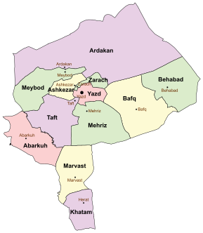
Khatam County is a county in Yazd Province in Iran. The capital of the county is Herat. At the 2006 census, the county's population was 31,695, in 8,144 families. The county is subdivided into two districts: the Central District and Marvast District. The county has two cities: Herat and Marvast.

Farsi is a district the west of Herat Province, Afghanistan. It borders on Obe District to the north, Adraskan District to the west, Shindand District to the south and Ghor Province to the south and east. The population was estimated at 29,800 in 2012. The district center is the village of Farsi.
Gulran is a village and the center of the Gulran District in Herat Province, Afghanistan. Like other parts of Herat province the population is overwhelmingly Persian with small pockets of Pashtun population.
Pashtun Zarghun District, formerly known as Posht-e Zirghān or Posht-e Zirghūn, is situated in the central part of Herat Province, Afghanistan in the valley of the Hari River. The district center is Pashtun Zarghun.
Shīnḍanḍ District is one of the 16 districts of Herat Province, in western Afghanistan, and is situated in the southern part of that province. It borders Adraskan District to the north, Ghor Province to the east and Farah Province to the south and west. The population was 173,800. The district center is the town of Shindand, which boasts a very active market area. Shindand Air Base is located near the town. The main Herat-Kandahar road passes through the district. The Zerkoh Valley is in the district.
Shīnḍanḍ is a town and the center of the Shindand District, Herat Province, Afghanistan. It is located at 33.3036°N 62.14°E at 1,066 m altitude. The Shindand Air Base is located about 15 miles northeast of the town.
Bazargan is a village in Herat Province, Afghanistan.

Bādghīs is one of the thirty-four provinces of Afghanistan, located in the northwest of the country next to Turkmenistan. It is counted as one of the most underdeveloped of the country's provinces. The capital is Qala i Naw, while the most populous city and district is Bala Murghab. The ruins of the medieval city of Marw al-Rudh, the historical capital of the medieval region of Gharjistan, are located in the province near the modern city of Bala Murghab.

Islām Qala, known historically as Kafir Qala, is a border town in the western Herat province of Afghanistan, near the border with Iran. It is the official entry by land from neighboring Taybad, Iran.
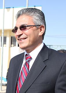
Dr. Daud Shah Saba is a politician in Afghanistan, who is serving as Governor of Herat Province since August 2010 when his predecessor Ahmad Yusuf Nuristani had resigned from the post.

Herat is a city and capital of Khatam County, Yazd Province, Iran. At the 2006 census, its population was 10,795, in 2,751 families.


