
Nové Hony is a village and municipality in Lučenec District in the Banská Bystrica Region of central Slovakia.
Arbasy Duże is a village in the administrative district of Gmina Drohiczyn, within Siemiatycze County, Podlaskie Voivodeship, in north-eastern Poland.

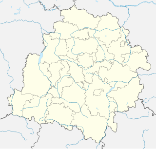
Konstantynów is a village in the administrative district of Gmina Biała Rawska, within Rawa County, Łódź Voivodeship, in central Poland. It lies approximately 7 kilometres (4 mi) south-east of Biała Rawska, 21 km (13 mi) east of Rawa Mazowiecka, and 75 km (47 mi) east of the regional capital Łódź.
Wilkowice is a village in the administrative district of Gmina Rawa Mazowiecka, within Rawa County, Łódź Voivodeship, in central Poland. It lies approximately 11 kilometres (7 mi) north-west of Rawa Mazowiecka and 47 km (29 mi) east of the regional capital Łódź.
Karolina is a village in the administrative district of Gmina Goszczanów, within Sieradz County, Łódź Voivodeship, in central Poland. It lies approximately 5 kilometres (3 mi) north-west of Goszczanów, 32 km (20 mi) north-west of Sieradz, and 69 km (43 mi) west of the regional capital Łódź.
Dąbrówka is a village in the administrative district of Gmina Sieradz, within Sieradz County, Łódź Voivodeship, in central Poland. It lies approximately 7 kilometres (4 mi) south-west of Sieradz and 59 km (37 mi) south-west of the regional capital Łódź.
Uników is a village in the administrative district of Gmina Złoczew, within Sieradz County, Łódź Voivodeship, in central Poland. It lies approximately 5 kilometres (3 mi) west of Złoczew, 27 km (17 mi) south-west of Sieradz, and 77 km (48 mi) south-west of the regional capital Łódź.
Bedlno is a village in the administrative district of Gmina Radzyń Podlaski, within Radzyń Podlaski County, Lublin Voivodeship, in eastern Poland. The village is the seat of the administrative district (gmina) known as Gmina Bedlno. It has a population of approximately 640.
Orłowiny is a village in the administrative district of Gmina Wojciechowice, within Opatów County, Świętokrzyskie Voivodeship, in south-central Poland. It lies approximately 3 kilometres (2 mi) south-west of Wojciechowice, 11 km (7 mi) east of Opatów, and 67 km (42 mi) east of the regional capital Kielce.
Kępina is a village in the administrative district of Gmina Radzanów, within Białobrzegi County, Masovian Voivodeship, in east-central Poland. It lies approximately 4 kilometres (2 mi) north-west of Radzanów, 13 km (8 mi) south-west of Białobrzegi, and 73 km (45 mi) south of Warsaw.
Piotrkowice is a village in the administrative district of Gmina Kozienice, within Kozienice County, Masovian Voivodeship, in east-central Poland. It lies approximately 7 kilometres (4 mi) north of Kozienice and 75 km (47 mi) south-east of Warsaw.
Góry is a village in the administrative district of Gmina Goworowo, within Ostrołęka County, Masovian Voivodeship, in east-central Poland. It lies approximately 9 kilometres (6 mi) south of Goworowo, 27 km (17 mi) south of Ostrołęka, and 79 km (49 mi) north-east of Warsaw.
Strzyżewice is a village in the administrative district of Gmina Święciechowa, within Leszno County, Greater Poland Voivodeship, in west-central Poland.
Łojewo is a village in the administrative district of Gmina Damnica, within Słupsk County, Pomeranian Voivodeship, in northern Poland. It lies approximately 7 kilometres (4 mi) north-east of Damnica, 23 km (14 mi) north-east of Słupsk, and 86 km (53 mi) west of the regional capital Gdańsk.
Nowa Pilona is a village in the administrative district of Gmina Elbląg, within Elbląg County, Warmian-Masurian Voivodeship, in northern Poland. It lies approximately 10 kilometres (6 mi) east of Elbląg and 72 km (45 mi) north-west of the regional capital Olsztyn.
Janiki Wielkie is a village in the administrative district of Gmina Zalewo, within Iława County, Warmian-Masurian Voivodeship, in northern Poland.
Nory is a village in the administrative district of Gmina Wieliczki, within Olecko County, Warmian-Masurian Voivodeship, in northern Poland.
Kamienny Jaz is a village in the administrative district of Gmina Chojna, within Gryfino County, West Pomeranian Voivodeship, in north-western Poland, close to the German border. It lies approximately 9 kilometres (6 mi) east of Chojna, 30 km (19 mi) south of Gryfino, and 49 km (30 mi) south of the regional capital Szczecin.
Õle is a village in Järva Parish, Järva County in northern-central Estonia.

Mihajlovac is a village in the municipality of Smederevo, Serbia. According to the 2011 census, the village has a population of 2,674 people.


