Nowa Sól County is a unit of territorial administration and local government (powiat) in Lubusz Voivodeship, western Poland. It came into being on January 1, 1999, as a result of the Polish local government reforms passed in 1998. Its administrative seat and largest town is Nowa Sól, which lies 22 km (14 mi) south-east of Zielona Góra and 109 km (68 mi) south of Gorzów Wielkopolski. The county contains three other towns: Kożuchów, lying 10 km (6 mi) south-west of Nowa Sól, Bytom Odrzański, lying 11 km (7 mi) south-east of Nowa Sól, and Nowe Miasteczko, 13 km (8 mi) south of Nowa Sól.

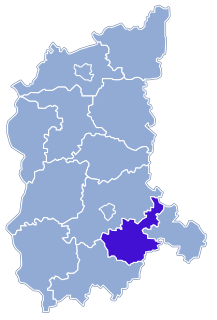
Bytom Odrzański is a town on the Oder river in western Poland, in Nowa Sól County of Lubusz Voivodeship.
Gmina Nowa Sól is a rural gmina in Nowa Sól County, Lubusz Voivodeship, in western Poland. Its seat is the town of Nowa Sól, although the town is not part of the territory of the gmina.
Gmina Nowe Miasteczko is an urban-rural gmina in Nowa Sól County, Lubusz Voivodeship, in western Poland. Its seat is the town of Nowe Miasteczko, which lies approximately 13 kilometres (8 mi) south of Nowa Sól and 33 km (21 mi) south-east of Zielona Góra.
Gmina Siedlisko is a rural gmina in Nowa Sól County, Lubusz Voivodeship, in western Poland. Its seat is the village of Siedlisko, which lies approximately 8 kilometres (5 mi) south-east of Nowa Sól and 29 km (18 mi) south-east of Zielona Góra.
Gmina Niegosławice is a rural gmina in Żagań County, Lubusz Voivodeship, in western Poland. Its seat is the village of Niegosławice, which lies approximately 28 kilometres (17 mi) east of Żagań and 42 km (26 mi) south of Zielona Góra.

Bodzów is a village in the administrative district of Gmina Bytom Odrzański, within Nowa Sól County, Lubusz Voivodeship, in western Poland. It lies approximately 5 kilometres (3 mi) south-east of Bytom Odrzański, 15 km (9 mi) south-east of Nowa Sól, and 36 km (22 mi) south-east of Zielona Góra.
Bonów, is a village in the administrative district of Gmina Bytom Odrzański, within Nowa Sól County, Lubusz Voivodeship, in western Poland. It lies approximately 6 kilometres (4 mi) south of Bytom Odrzański, 16 km (10 mi) south-east of Nowa Sól, and 37 km (23 mi) south-east of Zielona Góra.
Bycz is a village in the administrative district of Gmina Bytom Odrzański, within Nowa Sól County, Lubusz Voivodeship, in western Poland. It lies approximately 2 kilometres (1 mi) west of Bytom Odrzański, 10 km (6 mi) south-east of Nowa Sól, and 31 km (19 mi) south-east of Zielona Góra.
Drogomil is a village in the administrative district of Gmina Bytom Odrzański, within Nowa Sól County, Lubusz Voivodeship, in western Poland. It lies approximately 3 kilometres (2 mi) south-east of Bytom Odrzański, 14 km (9 mi) south-east of Nowa Sól, and 35 km (22 mi) south-east of Zielona Góra.
Kropiwnik is a village in the administrative district of Gmina Bytom Odrzański, within Nowa Sól County, Lubusz Voivodeship, in western Poland.
Małaszowice is a village in the administrative district of Gmina Bytom Odrzański, within Nowa Sól County, Lubusz Voivodeship, in western Poland. It lies approximately 5 kilometres (3 mi) south-west of Bytom Odrzański, 13 km (8 mi) south-east of Nowa Sól, and 33 km (21 mi) south-east of Zielona Góra.
Popowo is a village in the administrative district of Gmina Bytom Odrzański, within Nowa Sól County, Lubusz Voivodeship, in western Poland. It lies approximately 6 kilometres (4 mi) south of Bytom Odrzański, 15 km (9 mi) south-east of Nowa Sól, and 35 km (22 mi) south-east of Zielona Góra.
Sobolice is a village in the administrative district of Gmina Bytom Odrzański, within Nowa Sól County, Lubusz Voivodeship, in western Poland. It lies approximately 7 kilometres (4 mi) south-east of Bytom Odrzański, 16 km (10 mi) south-east of Nowa Sól, and 38 km (24 mi) south-east of Zielona Góra.
Tarnów Bycki is a village in the administrative district of Gmina Bytom Odrzański, within Nowa Sól County, Lubusz Voivodeship, in western Poland. It lies approximately 3 kilometres (2 mi) west of Bytom Odrzański, 9 km (6 mi) south-east of Nowa Sól, and 30 km (19 mi) south-east of Zielona Góra.
Wierzbnica is a village in the administrative district of Gmina Bytom Odrzański, within Nowa Sól County, Lubusz Voivodeship, in western Poland. It lies approximately 4 kilometres (2 mi) south of Bytom Odrzański, 13 km (8 mi) south-east of Nowa Sól, and 34 km (21 mi) south-east of Zielona Góra.
Podbrzezie Górne is a village in the administrative district of Gmina Kożuchów, within Nowa Sól County, Lubusz Voivodeship, in western Poland. It lies approximately 3 kilometres (2 mi) south-west of Kożuchów, 13 km (8 mi) south-west of Nowa Sól, and 24 km (15 mi) south of Zielona Góra.

Siedlisko is a village on the Oder river in Nowa Sól County, Lubusz Voivodeship, in western Poland. It is the seat of the gmina called Gmina Siedlisko. It lies approximately 8 kilometres (5 mi) south-east of Nowa Sól and 29 km (18 mi) south-east of Zielona Góra.
The Bytom Odrzański mine is a large mine in the west of Poland in Bytom Odrzański, Nowa Sól County, 360 km south-west of the capital, Warsaw. Bytom Odrzański represents one of the largest copper and silver reserve in Poland having estimated reserves of 31.5 million tonnes of ore grading 2.47% copper and 56 g/tonnes silver. The annual ore production is around 0.7 million tonnes from which 17,300 tonnes of copper and 39.2 tonnes of silver are extracted.


