Kramarovci

Last updated
Kramarovci
Prekm. Kramarovci 03.jpg
Slovenia location map.svg
Red pog.svg
Kramarovci
Location in Slovenia
Coordinates: 46°48′34.43″N16°0′5.88″E / 46.8095639°N 16.0016333°E / 46.8095639; 16.0016333 Coordinates: 46°48′34.43″N16°0′5.88″E / 46.8095639°N 16.0016333°E / 46.8095639; 16.0016333
Country Flag of Slovenia.svg Slovenia
Traditional region Prekmurje
Statistical region Mura
Municipality Rogašovci
Area
  Total 1.94 km2 (0.75 sq mi)
Elevation 277.6 m (910.8 ft)
Population (2002)
  Total 60
[1]

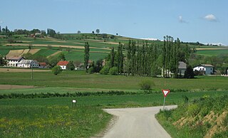
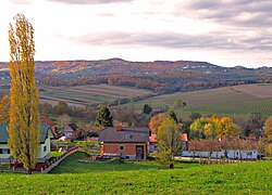
Kramarovci (pronounced  [ˈkɾaːmaɾɔu̯tsi] ; Hungarian : Határfalva, [2] German : Sinnersdorf [3] [4] ) is a small village in the Municipality of Rogašovci in the Prekmurje region of northeastern Slovenia, right on the border with Austria. [5]

Hungarian language language spoken in and around Hungary

Hungarian is a Finno-Ugric language spoken in Hungary and parts of several neighbouring countries. It is the official language of Hungary and one of the 24 official languages of the European Union. Outside Hungary it is also spoken by communities of Hungarians in the countries that today make up Slovakia, western Ukraine (Subcarpathia), central and western Romania (Transylvania), northern Serbia (Vojvodina), northern Croatia and northern Slovenia. It is also spoken by Hungarian diaspora communities worldwide, especially in North America and Israel. Like Finnish and Estonian, Hungarian belongs to the Uralic language family. With 13 million speakers, it is the family's largest member by number of speakers.

German language West Germanic language

German is a West Germanic language that is mainly spoken in Central Europe. It is the most widely spoken and official or co-official language in Germany, Austria, Switzerland, South Tyrol (Italy), the German-speaking Community of Belgium, and Liechtenstein. It is also one of the three official languages of Luxembourg and a co-official language in the Opole Voivodeship in Poland. The languages which are most similar to German are the other members of the West Germanic language branch: Afrikaans, Dutch, English, the Frisian languages, Low German/Low Saxon, Luxembourgish, and Yiddish. There are also strong similarities in vocabulary with Danish, Norwegian and Swedish, although those belong to the North Germanic group. German is the second most widely spoken Germanic language, after English.

Village Small clustered human settlement smaller than a town

A village is a clustered human settlement or community, larger than a hamlet but smaller than a town, with a population ranging from a few hundred to a few thousand. Though villages are often located in rural areas, the term urban village is also applied to certain urban neighborhoods. Villages are normally permanent, with fixed dwellings; however, transient villages can occur. Further, the dwellings of a village are fairly close to one another, not scattered broadly over the landscape, as a dispersed settlement.

There is a small chapel in the centre of the settlement. It was built in the early 20th century and has a belfry attached to it. [6] Until 1945 the village had a German majority.[ citation needed ]

Chapel Religious place of fellowship attached to a larger institution

The term chapel usually refers to a Christian place of prayer and worship that is attached to a larger, often nonreligious institution or that is considered an extension of a primary religious institution. It may be part of a larger structure or complex, such as a college, hospital, palace, prison, funeral home, church, synagogue or mosque, located on board a military or commercial ship, or it may be an entirely free-standing building, sometimes with its own grounds. Chapel has also referred to independent or nonconformist places of worship in Great Britain—outside the established church.

Bell tower a tower that contains one or more bells, or that is designed to hold bells

A bell tower is a tower that contains one or more bells, or that is designed to hold bells even if it has none. Such a tower commonly serves as part of a church, and will contain church bells, but there are also many secular bell towers, often part of a municipal building, an educational establishment, or a tower built specifically to house a carillon. Church bell towers often incorporate clocks, and secular towers usually do, as a public service.

Related Research Articles

ISO 3166-2:SI is the entry for Slovenia in ISO 3166-2, part of the ISO 3166 standard published by the International Organization for Standardization (ISO), which defines codes for the names of the principal subdivisions of all countries coded in ISO 3166-1.

Sankt Georgen may refer to several places, all named after the German name of Saint George:

Rogašovci Town and Municipality in Slovenia

Rogašovci is a settlement and a municipality in Slovenia. It is part of the Prekmurje region.

Iván Bassa Slovenian priest and writer

Iván Bassa Slovene Ivan Baša Slovenian Roman Catholic priest, writer and politic.

Mura Statistical Region Statistical region

The Mura Statistical Region is a statistical region in northeast Slovenia. It is predominantly agricultural with field crops representing over three-quarters of the total agricultural area. Climate and soil combined have made it the region with the highest crop production, but its geographical position and inferior infrastructure put it at a disadvantage and it is the region of Slovenia with the lowest GDP per capita and the highest rate of registered unemployment.

Fikšinci Place in Prekmurje, Slovenia

Fikšinci is a village in the Municipality of Rogašovci in the Prekmurje region of northeastern Slovenia.

Nuskova Place in Prekmurje, Slovenia

Nuskova is a village in the Municipality of Rogašovci in the Prekmurje region of northeastern Slovenia.

Pertoča Place in Prekmurje, Slovenia

Pertoča is a village in the municipality of Rogašovci in the Prekmurje region of northeastern Slovenia.

Ropoča Place in Prekmurje, Slovenia

Ropoča is a village in the Municipality of Rogašovci in the Prekmurje region of northeastern Slovenia. The Ledava River flows into a reservoir just south of the main settlement.

Serdica, Rogašovci Place in Prekmurje, Slovenia

Serdica is a village in the Municipality of Rogašovci in the Prekmurje region of northeastern Slovenia.

Sotina Place in Prekmurje, Slovenia

Sotina is a village in the Municipality of Rogašovci in the Prekmurje region of northeastern Slovenia. The village includes the following hamlets: Bezovkova Graba, Maribor, Bracov Dol, Činčov Breg, Kolarova Graba, Majcov Mlin, Martinova Graba, Patrov Breg, Tomanov Breg, and Turzov Breg.

Sveti Jurij, Rogašovci Place in Prekmurje, Slovenia

Sveti Jurij is a village in the Municipality of Rogašovci in the Prekmurje region of northeastern Slovenia.

Večeslavci Place in Prekmurje, Slovenia

Večeslavci is a village in the Municipality of Rogašovci in the Prekmurje region of northeastern Slovenia.

Bistrica, Črnomelj Place in White Carniola, Slovenia

Bistrica is a small settlement in the hills west of Črnomelj in the White Carniola area of southeastern Slovenia. The area is part of the traditional region of Lower Carniola and is now included in the Southeast Slovenia Statistical Region. It is located on a rocky terrace with sinkholes along the road from Črnomelj to the Poljane Valley.

Koblarji Place in Lower Carniola, Slovenia

Koblarji is a settlement northwest of Kočevje in southern Slovenia. The area is part of the traditional region of Lower Carniola and is now included in the Southeast Slovenia Statistical Region. Koblarji Cave is located in the settlement.

Primoži in Lower Carniola, Slovenia

Primoži is a small settlement in the Municipality of Kočevje in southern Slovenia. The area is part of the traditional region of Lower Carniola and is now included in the Southeast Slovenia Statistical Region.

Jurij may refer to:

Vrčice Place in Lower Carniola, Slovenia

Vrčice is a small settlement in the Municipality of Semič in Slovenia. The area is part of the historical region of Lower Carniola. The municipality is now included in the Southeast Slovenia Statistical Region.

Ravne, Kočevje in Lower Carniola, Slovenia

Ravne is a remote settlement in the Municipality of Kočevje in southern Slovenia. The area is part of the traditional region of Lower Carniola and is now included in the Southeast Slovenia Statistical Region. Its territory is now part of the village of Borovec pri Kočevski Reki.

Nogometni klub Goričanka Rogašovci, commonly referred to as NK Goričanka or simply Goričanka, is a Slovenian football club which plays its home matches at a 147 capacity stadium in the village of Sveti Jurij in the Municipality of Rogašovci. The club was founded in 1977 and traditionally wears red kits though in recent years the club has adopted a blue and yellow home kit.

References

  1. Statistical Office of the Republic of Slovenia
  2. Vengušt, Jernej. 1919. Seznamek prekmurskih občin (krajev) z označbo pošte in zemljevidom. Radgona, p. 8.
  3. Balažic, Janez. 1996. Völker an der Mur. Murska Sobota: Pokrajinski muzej, p. 231.
  4. Killer, Kurt. 2001. Lithokarten aus Österreich: mit besonderer Berücksichtigung der Steiermark. Graz: author, p. 187.
  5. Rogašovci municipal site
  6. Slovenian Ministry of Culture register of national heritage reference number 12287