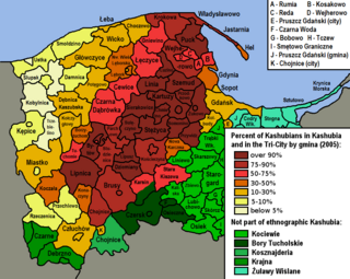
The Kashubians, also known as Cassubians or Kashubs, are a Lechitic ethnic group native to the historical region of Pomerania, including its eastern part called Pomerelia, in north-central Poland. Their settlement area is referred to as Kashubia. They speak the Kashubian language, which is classified as a separate language closely related to Polish.

The Polish Corridor, also known as the Pomeranian Corridor, Danzig Corridor or Gdańsk Corridor, was a territory located in the region of Pomerelia, which provided the Second Polish Republic with access to the Baltic Sea, thus dividing the bulk of Weimar Germany from the province of East Prussia. At its narrowest point, the Polish territory was just 30 km wide. The Free City of Danzig, situated to the east of the corridor, was a semi-independent German speaking city-state forming part of neither Germany nor Poland, though united with the latter through an imposed union covering customs, mail, foreign policy, railways as well as defence.

Kreis Birnbaum was a district in Prussia (Kreis) in the west of the Grand Duchy of Posen and the succeeding Province of Posen, as part of Regierungsbezirk Posen between 1815 and 1920. Today the area belongs to the Polish voivodeships of Greater Poland and Lubusz.

Kreis Schrimm was a district in the southern administrative region of Posen, in the Prussian province of Posen. The district capital was Schrimm. Its territory presently lies in the southern part of the Greater Poland Voivodeship in Poland.

The Danziger Höhe was an administrative district founded in 1887 and dissolved in 1939. The district administration was based in the City of Danzig, which itself did not form part of the district but was an independent city (Stadtkreis). The area Danziger Höhe covered is now within Poland.

The Province of West Prussia was a province of Prussia from 1773 to 1829 and 1878 to 1919. West Prussia was established as a province of the Kingdom of Prussia in 1773, formed from Royal Prussia of the Polish–Lithuanian Commonwealth annexed in the First Partition of Poland. West Prussia was dissolved in 1829 and merged with East Prussia to form the Province of Prussia, but was re-established in 1878 when the merger was reversed and became part of the German Empire. From 1918, West Prussia was a province of the Free State of Prussia within Weimar Germany, losing most of its territory to the Second Polish Republic and the Free City of Danzig in the Treaty of Versailles. West Prussia was dissolved in 1920, and its remaining western territory was merged with Posen to form Posen-West Prussia, and its eastern territory merged with East Prussia as the Region of West Prussia district.

Farther Pomerania, Hinder Pomerania, Rear Pomerania or Eastern Pomerania, is a subregion of the historic region of Pomerania in north-western Poland, mostly within the West Pomeranian Voivodeship, while its easternmost parts are within the Pomeranian Voivodeship.
Landkreis Marienwerder was a Kreis, or district, of Prussia from 1752 to 1945. Its capital was Marienwerder (Kwidzyn).

The Danzig Region was a government region, within the Prussian Provinces of West Prussia and Prussia. The regional capital was Danzig (Gdańsk). Prussian government regions were not bodies of regional self-rule of the districts and cities comprised, but shear top-to-down government agencies to apply federal or state law and supervise local entities of self-rules, such as municipalities, rural and urban districts.
Babidół is a village in the administrative district of Gmina Kolbudy, within Gdańsk County, Pomeranian Voivodeship, in northern Poland. It lies approximately 3 kilometres (2 mi) south-west of Kolbudy, 13 km (8 mi) west of Pruszcz Gdański, and 18 km (11 mi) south-west of the regional capital Gdańsk.
Arciszewo is a village in the administrative district of Gmina Pruszcz Gdański, within Gdańsk County, Pomeranian Voivodeship, in northern Poland. It lies approximately 5 kilometres (3 mi) west of Pruszcz Gdański and 13 km (8 mi) south of the regional capital Gdańsk.

Sulmin is a village in the administrative district of Gmina Żukowo, within Kartuzy County, Pomeranian Voivodeship, in northern Poland.

Landkreis Namslau was a district in Prussian Silesia, from 1742 to 1945. The district capital was at Namslau (Namysłów). Today, the territory of the district is located in the Polish Opole Voivodeship.
Kreis Dirschau was a Prussian district which existed with varying borders from 1772 to 1818 and from 1887 to 1920. In 1920, following World War I the district was ceded by the German Empire partly to Poland and partly to the Free City of Danzig in accordance Treaty of Versailles. From 1939 to 1945 the district in occupied Poland was re-established as part of the wartime Reichsgau Danzig-West Prussia. Today the former district is in the Polish Pomeranian Voivodeship.

The Groß Wartenberg district, known until 1888 as the Wartenberg district, was a Prussian district in Silesia from 1742 to 1945. Its capital was the town of Groß Wartenberg (Syców), which was known until 1888 as Polnisch Wartenberg. The area of this district now lies within the Lower Silesian Voivodeship of Poland.

The Flatow district was a district that existed from 1818 to 1945 in the Kingdom of Prussia and Germany. It belonged to the province of West Prussia until 1920. After World War I, the eastern portion of the district was ceded to Poland. The western portion of the district remained in Germany and became part of the Frontier March of Posen-West Prussia until 1938. The district then became part of the Province of Pomerania from 1938 to 1945. Today the territory of the Flatow district lies in the Kuyavian-Pomeranian Voivodeship and the Greater Poland Voivodeship in Poland.

The district of Graudenz was a Prussian district in the administrative region of Marienwerder that existed from 1818 to 1920. It belonged to the province of West Prussia until 1829 and then again from 1878 to 1920. Between 1829 and 1878, it belonged to the Province of Prussia. It was located in the part of West Prussia that fell to Poland after the World War I in 1920 through the Treaty of Versailles. The city of Graudenz, was part of the district until 1900, after which it formed its own independent urban district.
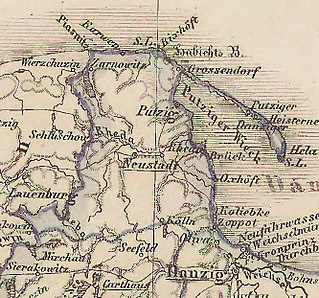
The Neustadt district was a Prussian district that existed from 1818 to 1920. It was in the part of West Prussia that fell to Poland after World War I through the Treaty of Versailles. From 1939 to 1945 the district was re-established in occupied Poland as part of the Reichsgau Danzig-West Prussia. Today the area of the former district is in the Polish Pomeranian Voivodeship.
The Berent district was a Prussian district that existed from 1818 to 1920. It was in the part of West Prussia that fell to Poland after World War I in 1920. Its capital was Berent. From 1939 to 1945, the district was re-established in German-occupied Poland as part of the newly established Reichsgau Danzig-West Prussia. Today the territory of the district is located in the Polish Pomeranian Voivodeship.

The Preußisch Stargard district was a Prussian district that existed from 1772 to 1920 with varying borders. It was in the part of West Prussia that fell to Poland after World War I through the Treaty of Versailles in 1920. Its county seat was Preußisch Stargard. From 1939 to 1945 the district was re-established in German-occupied Poland as part of the newly established Reichsgau Danzig-West Prussia. Today the territory of the district is located in the Polish Pomeranian Voivodeship.

