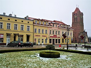
Prabuty is a town in Kwidzyn County within the Pomeranian Voivodeship of northern Poland. It is the seat of Gmina Prabuty.

The Marienwerder Region was a government region (Regierungsbezirk) of Prussia from 1815 until 1920 and again 1939-1945. It was a part of the Province of West Prussia from 1815 to 1829, and again 1878–1920, belonging to the Province of Prussia in the intervening years, and to the Reichsgau Danzig-West Prussia in the years 1939-1945. The regional capital was Marienwerder in West Prussia.

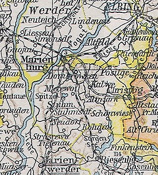
Malbork is a town in the Pomeranian Voivodeship, Poland. It is the seat of Malbork County and has a population of 37,898 people as of 2021. The town is located on the Nogat river, in the historical region of Pomerelia.
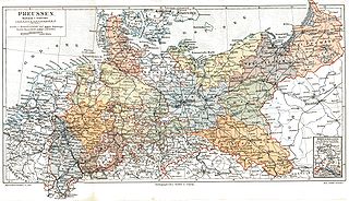
The Provinces of Prussia were the main administrative divisions of Prussia from 1815 to 1946. Prussia's province system was introduced in the Stein-Hardenberg Reforms in 1815, and were mostly organized from duchies and historical regions. Provinces were divided into several Regierungsbezirke, sub-divided into Kreise (districts), and then into Gemeinden (townships) at the lowest level. Provinces constituted the highest level of administration in the Kingdom of Prussia and Free State of Prussia until 1933, when Nazi Germany established de facto direct rule over provincial politics, and were formally abolished in 1946 following World War II. The Prussian provinces became the basis for many federal states of Germany, and the states of Brandenburg, Lower Saxony, and Schleswig-Holstein are direct successors of provinces.

The Province of West Prussia was a province of Prussia from 1773 to 1829 and 1878 to 1920. West Prussia was established as a province of the Kingdom of Prussia in 1773, formed from Royal Prussia of the Polish–Lithuanian Commonwealth annexed in the First Partition of Poland. West Prussia was dissolved in 1829 and merged with East Prussia to form the Province of Prussia, but was re-established in 1878 when the merger was reversed and became part of the German Empire. From 1918, West Prussia was a province of the Free State of Prussia within Weimar Germany, losing most of its territory to the Second Polish Republic and the Free City of Danzig in the Treaty of Versailles. West Prussia was dissolved in 1920, and its remaining western territory was merged with Posen to form Posen-West Prussia, and its eastern territory merged with East Prussia as the Region of West Prussia district.
Landkreis Marienwerder was a Kreis, or district, of Prussia from 1752 to 1945. Its capital was Marienwerder (Kwidzyn).
The West Prussia Region was a government region (Regierungsbezirk) of Prussia from 1920 until 1939. The regional capital was Marienwerder in West Prussia. It was the eastern part of Marienwerder Region which voted to be incorporated within the Weimar Republic and joined the Province of East Prussia from 1922 to 1939. It was replaced again by the reconstituted Marienwerder Region in 1939 until its dissolution in 1945.
The Danzig Region was a government region, within the Prussian Provinces of West Prussia and of Prussia. The regional capital was Danzig (Gdańsk). Prussian government regions were not bodies of regional self-rule of the districts and cities comprised, but shear top-to-down government agencies to apply federal or state law and supervise local entities of self-rules, such as municipalities, rural and urban districts.
Nowa Tuchola is a settlement, part of the village of Mały Mędromierz in the administrative district of Gmina Tuchola, within Tuchola County, Kuyavian-Pomeranian Voivodeship, in north-central Poland.
Kreis Dirschau was a Prussian district which existed with varying borders from 1772 to 1818 and from 1887 to 1920. In 1920, following World War I the district was ceded by the German Empire partly to Poland and partly to the Free City of Danzig in accordance Treaty of Versailles. From 1939 to 1945 the district in occupied Poland was re-established as part of the wartime Reichsgau Danzig-West Prussia. Today the former district is in the Polish Pomeranian Voivodeship.

The Karthaus district was a Prussian district that existed from 1818 to 1920. It was located in the part of West Prussia that fell to Poland after World War I through the Treaty of Versailles in 1920, as part of the Polish Corridor. The capital of the district was Karthaus. From 1939 to 1945, the district was re-established as part of Reichsgau Danzig-West Prussia in occupied Poland. Today the territory of the district lies in the Polish Pomeranian Voivodeship.
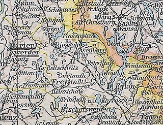
The district of Rosenberg in Westpreußen was a Prussian district that existed from 1818 to 1945. The territory of the district is now located within the Polish Warmian-Masurian Voivodeship.
The Stuhm district was a Prussian district that existed between 1818 and 1945. It belonged to the part of West Prussia that remained in the German Reich after World War I and was since part of the province of East Prussia. Today, the territory of the district is located in the Pomeranian Voivodeship in Poland.
Kreis Schwetz was a Prussian district that existed from 1818 to 1920, with its capital at Schwetz. The district was located on the western bank of the Vistula river in the part of West Prussia that fell to Poland after the First World War through the Treaty of Versailles in 1920.
The Löbau district was a Prussian district in the Marienwerder administrative region that existed from 1818 to 1920. The seat of the district administration was in the city of Neumark. The district belonged to the part of West Prussia that fell to Poland after World War I through the Treaty of Versailles in 1920. Today, the territory of the district is in the Warmian-Masurian Voivodeship in Poland.

The district of Deutsch Krone was a district in Prussia from 1772 to 1945. It belonged to the part of West Prussia that remained in the German Reich after World War I and became part of the Province of Grenzmark Posen-West Prussia. From 1938 to 1945, it belonged to the Province of Pomerania. Today the territory of the district area lies in the Polish Voivodeships of West Pomerania and Greater Poland.

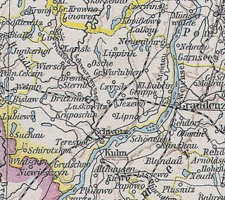
The district of Graudenz was a Prussian district in the administrative region of Marienwerder that existed from 1818 to 1920. It belonged to the province of West Prussia until 1829 and then again from 1878 to 1920. Between 1829 and 1878, it belonged to the Province of Prussia. It was located in the part of West Prussia that fell to Poland after the World War I in 1920 through the Treaty of Versailles. The city of Graudenz, was part of the district until 1900, after which it formed its own independent urban district.
The Berent district was a Prussian district that existed from 1818 to 1920. It was in the part of West Prussia that fell to Poland after World War I in 1920. Its capital was Berent. From 1939 to 1945, the district was re-established in German-occupied Poland as part of the newly established Reichsgau Danzig-West Prussia. Today the territory of the district is located in the Polish Pomeranian Voivodeship.

The district of Thorn was a Prussian district in the Marienwerder administrative region that existed from 1818 to 1920. It belonged to the province of West Prussia, except for the period from 1829 to 1878 when it was part of the Province of Prussia. Its capital was Thorn. It was in the part of West Prussia that fell to Poland after World War I in 1920 through the Treaty of Versailles. From 1939 to 1945, the district of Thorn was re-established in Reichsgau Danzig-West Prussia in occupied Poland. Today, the area of the district is in the Kuyavian-Pomeranian Voivodeship in Poland.

The Preußisch Stargard district was a Prussian district that existed from 1772 to 1920 with varying borders. It was in the part of West Prussia that fell to Poland after World War I through the Treaty of Versailles in 1920. Its county seat was Preußisch Stargard. From 1939 to 1945 the district was re-established in German-occupied Poland as part of the newly established Reichsgau Danzig-West Prussia. Today the territory of the district is located in the Polish Pomeranian Voivodeship.


