Florczaki is a village in the administrative district of Gmina Łukta, within Ostróda County, Warmian-Masurian Voivodeship, in northern Poland. It lies approximately 7 kilometres (4 mi) north-west of Łukta, 18 km (11 mi) north of Ostróda, and 32 km (20 mi) west of the regional capital Olsztyn.
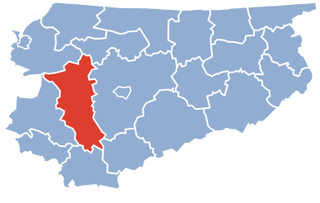
Borzymowo is a village in the administrative district of Gmina Morąg, within Ostróda County, Warmian-Masurian Voivodeship, in northern Poland. It lies approximately 8 kilometres (5 mi) north of Morąg, 32 km (20 mi) north of Ostróda, and 44 km (27 mi) north-west of the regional capital Olsztyn.
Chojnik is a village in the administrative district of Gmina Morąg, within Ostróda County, Warmian-Masurian Voivodeship, in northern Poland. It lies approximately 11 kilometres (7 mi) west of Morąg, 31 km (19 mi) north-west of Ostróda, and 51 km (32 mi) west of the regional capital Olsztyn.
Dobrocinek is a village in the administrative district of Gmina Morąg, within Ostróda County, Warmian-Masurian Voivodeship, in northern Poland. It lies approximately 7 kilometres (4 mi) west of Morąg, 28 km (17 mi) north of Ostróda, and 47 km (29 mi) west of the regional capital Olsztyn.
Dury is a village in the administrative district of Gmina Morąg, within Ostróda County, Warmian-Masurian Voivodeship, in northern Poland. It lies approximately 3 kilometres (2 mi) south-east of Morąg, 22 km (14 mi) north of Ostróda, and 38 km (24 mi) west of the regional capital Olsztyn.
Gubity is a village in the administrative district of Gmina Morąg, within Ostróda County, Warmian-Masurian Voivodeship, in northern Poland. It lies approximately 11 kilometres (7 mi) south-east of Morąg, 18 km (11 mi) north of Ostróda, and 31 km (19 mi) west of the regional capital Olsztyn.
Jurki is a village in the administrative district of Gmina Morąg, within Ostróda County, Warmian-Masurian Voivodeship, in northern Poland. It lies approximately 4 kilometres (2 mi) north of Morąg, 21 km (13 mi) north of Ostróda, and 39 km (24 mi) west of the regional capital Olsztyn.
Kępa Kalnicka is a village in the administrative district of Gmina Morąg, within Ostróda County, Warmian-Masurian Voivodeship, in northern Poland. It lies approximately 10 kilometres (6 mi) north-west of Morąg, 33 km (21 mi) north of Ostróda, and 49 km (30 mi) north-west of the regional capital Olsztyn.
Królewo is a village in the administrative district of Gmina Morąg, within Ostróda County, Warmian-Masurian Voivodeship, in northern Poland. It lies approximately 7 kilometres (4 mi) north-west of Morąg, 29 km (18 mi) north of Ostróda, and 47 km (29 mi) north-west of the regional capital Olsztyn.
Niebrzydowo Wielkie is a village in the administrative district of Gmina Morąg, within Ostróda County, Warmian-Masurian Voivodeship, in northern Poland. It lies approximately 7 kilometres (4 mi) north-east of Morąg, 30 km (19 mi) north of Ostróda, and 40 km (25 mi) north-west of the regional capital Olsztyn.
Prośno is a village in the administrative district of Gmina Morąg, within Ostróda County, Warmian-Masurian Voivodeship, in northern Poland. It lies approximately 11 kilometres (7 mi) south of Morąg, 14 km (9 mi) north of Ostróda, and 38 km (24 mi) west of the regional capital Olsztyn.
Raj is a village in the administrative district of Gmina Morąg, within Ostróda County, Warmian-Masurian Voivodeship, in northern Poland. It lies approximately 5 kilometres (3 mi) south of Morąg, 21 km (13 mi) north of Ostróda, and 40 km (25 mi) west of the regional capital Olsztyn.
Silin is a village in the administrative district of Gmina Morąg, within Ostróda County, Warmian-Masurian Voivodeship, in northern Poland. It lies approximately 4 kilometres (2 mi) south of Morąg, 21 km (13 mi) north of Ostróda, and 38 km (24 mi) west of the regional capital Olsztyn.
Słonecznik is a village in the administrative district of Gmina Morąg, within Ostróda County, Warmian-Masurian Voivodeship, in northern Poland. It lies approximately 9 kilometres (6 mi) south-west of Morąg, 18 km (11 mi) north of Ostróda, and 42 km (26 mi) west of the regional capital Olsztyn.
Tątławki is a village in the administrative district of Gmina Morąg, within Ostróda County, Warmian-Masurian Voivodeship, in northern Poland. It lies approximately 11 kilometres (7 mi) east of Morąg, 24 km (15 mi) north of Ostróda, and 31 km (19 mi) north-west of the regional capital Olsztyn.
Wenecja is a village in the administrative district of Gmina Morąg, within Ostróda County, Warmian-Masurian Voivodeship, in northern Poland. It lies approximately 9 kilometres (6 mi) south-west of Morąg, 20 km (12 mi) north-west of Ostróda, and 44 km (27 mi) west of the regional capital Olsztyn.
Wilnowo is a village in the administrative district of Gmina Morąg, within Ostróda County, Warmian-Masurian Voivodeship, in northern Poland. It lies approximately 9 kilometres (6 mi) east of Morąg, 25 km (16 mi) north of Ostróda, and 33 km (21 mi) north-west of the regional capital Olsztyn.
Żabi Róg is a village in the administrative district of Gmina Morąg, within Ostróda County, Warmian-Masurian Voivodeship, in northern Poland. It lies approximately 7 kilometres (4 mi) south-east of Morąg, 21 km (13 mi) north of Ostróda, and 34 km (21 mi) west of the regional capital Olsztyn.
Złotna is a village in the administrative district of Gmina Morąg, within Ostróda County, Warmian-Masurian Voivodeship, in northern Poland. It lies approximately 8 kilometres (5 mi) north of Morąg, 32 km (20 mi) north of Ostróda, and 46 km (29 mi) north-west of the regional capital Olsztyn.