
A cloverleaf interchange is a two-level interchange in which all turns are handled by slip roads. To go left, vehicles first continue as one road passes over or under the other, then exit right onto a one-way three-fourths loop ramp (270°) and merge onto the intersecting road. The objective of a cloverleaf is to allow two highways to cross without the need for any traffic to be stopped by traffic lights. The limiting factor in the capacity of a cloverleaf interchange is traffic weaving.

The Capital Beltway is a 64-mile (103 km) auxiliary Interstate Highway in the Washington metropolitan area that surrounds Washington, D.C., the capital of the United States, and its inner suburbs in adjacent Maryland and Virginia. It is the basis of the phrase "inside the Beltway", used when referring to issues dealing with US federal government and politics. The highway is signed as Interstate 495 (I-495) for its entire length, and its southern and eastern half runs concurrently with I-95.
Interstate 664 (I-664) is an auxiliary Interstate Highway in the US state of Virginia. The Interstate runs 20.79 miles (33.46 km) from I-64 and I-264 in Chesapeake north to I-64 in Hampton. I-664 forms the west side of the Hampton Roads Beltway, a circumferential highway serving the Hampton Roads metropolitan area. The Interstate crosses Hampton Roads via the Monitor–Merrimac Memorial Bridge–Tunnel (MMMBT) between Suffolk and Newport News. I-664 is connected to the other major cities of the metropolitan area—Portsmouth, Norfolk, and Virginia Beach—by I-264. The Interstate also has a connection to Portsmouth through State Route 164 (SR 164) and to Suffolk via U.S. Route 13 (US 13), US 58, and US 460.
Interstate 264 (I-264) is an Interstate Highway in the US state of Virginia. It serves as the primary east–west highway through the South Hampton Roads region in southeastern Virginia. The route connects the central business districts of Chesapeake, Portsmouth, Norfolk, and Virginia Beach and serves as the most direct link between those cities and the resort beaches along Virginia's Atlantic coast.

Interstate 283 (I-283) is an auxiliary route of the Interstate Highway System located just east of Harrisburg, Pennsylvania. It travels from the Harrisburg East interchange of I-76 north to I-83/U.S. Route 322 at the Eisenhower Interchange. Pennsylvania Route 283 continues southeast from near the southern terminus of I-283 to Lancaster as a freeway, functioning as an extension of the Interstate, though they are two separate roads.
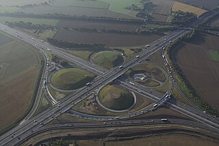
The Kamener Kreuz was formerly a full cloverleaf interchange near Dortmund in North Rhine-Westphalia Germany where the Autobahnen A1 and A2 meet. It lies between the towns of Kamen and Bergkamen in the west and the city of Hamm and the municipality Bönen in the east. The Kamener Kreuz, opened in 1937, was the second interchange between two Reichsautobahnen, the first one being the Schkeuditzer Kreuz. It is used by 160,000 vehicles per day.
A directional interchange, colloquially known as a stack interchange, is a type of grade-separated junction between two controlled-access highways that allows for free-flowing movement to and from all directions of traffic. These interchanges eliminate the problems of weaving, have the highest vehicle capacity, and vehicles travel shorter distances when compared to different types of interchanges.

Bundesautobahn 10 is an orbital motorway around the German capital city of Berlin. Colloquially called Berliner Ring , it is predominantly located in the state of Brandenburg, with a short stretch of 5 km in Berlin itself. It should not be confused with the Berliner Stadtring around Berlin's inner city.

Oranienburg is a railway station located in Oranienburg, Germany. The station was opened in 1877 is located on the Berlin Northern Railway and the now closed Nauen–Oranienburg railway and Oranienburg–Velten railway. The train services are operated by Deutsche Bahn and Niederbarnimer Eisenbahn.
The Cologne Beltway is the collective term for the Autobahns encircling Cologne. It consists of the Bundesautobahn 1, the Bundesautobahn 3 and the Bundesautobahn 4. Segments of the beltway handle the highest traffic volume in Germany.

The Wiesbadener Kreuz is a full cloverleaf interchange near the Hessian state capital of Wiesbaden in Germany where the Autobahnen A3 and A66 meet. It lies within the northeastern edge of Hochheim am Main. The interchange was opened in 1939 and was one of the first interchanges in Germany.
European route E 22 (E 22) is a west–east European route, running from Holyhead in the United Kingdom, through the Netherlands, Germany, Sweden and Latvia, to Ishim in Russia.
The Dreieck Havelland is a trumpet interchange in the German state of Brandenburg in the metropolitan region of Berlin.
The Kreuz Hegau is a Directional T interchange/Half-Cloverleaf interchange in the German state of Baden-Württemberg.

The Schönefelder Kreuz is a cloverleaf interchange, with a direct link Magdeburg-Berlin and also a direct link Frankfurt (Oder)-Dresden, in the German state of Brandenburg in the metropolitan region of Berlin-Brandenburg.
The Kreuz Hilden is a cloverleaf interchange in the German state North Rhine Westphalia.
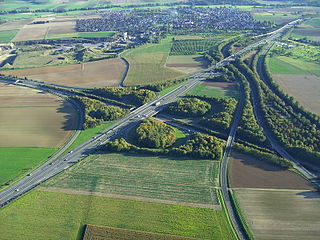
The Gambacher Kreuz is a cloverleaf interchange in Hesse, Germany where the A5 Autobahn from Basel to Bad Hersfeld intersects the A45 between Dortmund and Aschaffenburg. It constitutes a node in the primary route between the Rhein-Main metropolitan area and the eastern end of the Ruhr valley.
The Offenbacher Kreuz is a cloverleaf interchange in the Frankfurt Rhine-Main Metropolitan Region in the German state of Hesse.

The Hermsdorfer Kreuz is a cloverleaf interchange in the German state Thuringia.

The Kreuz Herne is a combination interchange with two cloverleaf links in the German state North Rhine-Westphalia.


