Birkenwerder

Last updated
Birkenwerder
Birkenwerderrathaus.jpg
Town hall
Wappen Birkenwerder.png
Location of Birkenwerder within Oberhavel district
Birkenwerder in OHV.png
Germany adm location map.svg
Red pog.svg
Birkenwerder
Brandenburg location map.svg
Red pog.svg
Birkenwerder
Coordinates: 52°41′N13°17′E / 52.683°N 13.283°E / 52.683; 13.283
Country Germany
State Brandenburg
District Oberhavel
Government
   Mayor (202331) Stephan Zimniok [1]
Area
  Total18.10 km2 (6.99 sq mi)
Highest elevation
56 m (184 ft)
Lowest elevation
32 m (105 ft)
Population
 (2022-12-31) [2]
  Total8,141
  Density450/km2 (1,200/sq mi)
Time zone UTC+01:00 (CET)
  Summer (DST) UTC+02:00 (CEST)
Postal codes
16547
Dialling codes 03303
Vehicle registration OHV
Website www.birkenwerder.de

Birkenwerder is a municipality in the Oberhavel district, in Brandenburg, Germany.

Contents

Geography

Birkenwerder is situated in the south of Oberhavel. The northern border of Berlin is 3 kilometres away. Birkenwerder shares his border with Oranienburg in the north, Mühlenbecker Land in the east and Hohen Neuendorf in the south and in the north. In the centre of Birkenwerder is the river Briese. In the west of Birkenwerder it empties in the River Havel. Briese and Lindenhof are districts (Wohnplätze  [ de ]) of Birkenwerder. More than 50% of the area consists of forest. There are many forest roads, also along the river Briese. Birkenwerder is connected to the motorway A 10 (Bundesautobahn 10), the B 96 (Bundesstraße 96) and the B 96a which ends in the centre of Birkenwerder.

Demography

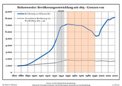
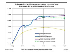
Birkenwerder: Population development
within the current boundaries [3]
YearPop.±% p.a.
1875 951    
1890 1,167+1.37%
1910 2,318+3.49%
1925 3,387+2.56%
1933 4,993+4.97%
1939 6,648+4.89%
1946 7,023+0.79%
1950 7,148+0.44%
1964 6,967−0.18%
1971 6,911−0.12%
1981 6,325−0.88%
1985 6,122−0.81%
1989 5,602−2.19%
1990 5,510−1.64%
1991 5,422−1.60%
YearPop.±% p.a.
1992 5,377−0.83%
1993 5,370−0.13%
1994 5,423+0.99%
1995 5,417−0.11%
1996 5,491+1.37%
1997 5,721+4.19%
1998 6,055+5.84%
1999 6,290+3.88%
2000 6,518+3.62%
2001 6,632+1.75%
2002 6,800+2.53%
2003 6,961+2.37%
2004 7,108+2.11%
2005 7,219+1.56%
2006 7,360+1.95%
YearPop.±% p.a.
2007 7,492+1.79%
2008 7,650+2.11%
2009 7,774+1.62%
2010 7,819+0.58%
2011 7,748−0.91%
2012 7,827+1.02%
2013 7,833+0.08%
2014 7,881+0.61%
2015 8,019+1.75%
2016 8,017−0.02%
2017 8,096+0.99%
2018 8,134+0.47%
2019 8,133−0.01%
2020 8,132−0.01%

Related Research Articles

Ostprignitz-Ruppin is a Kreis (district) in the northwestern part of Brandenburg, Germany. Neighboring are the districts Müritz and Mecklenburg-Strelitz in Mecklenburg-Western Pomerania, the districts Oberhavel and Havelland, the district Stendal in Saxony-Anhalt, and the district Prignitz.

Oberhavel is a Kreis (district) in the northern part of Brandenburg, Germany. Its neighbouring districts are : Mecklenburgische Seenplatte (district) in Mecklenburg-Western Pomerania, the districts of Uckermark and Barnim, the Bundesland of Berlin, and the districts of Havelland and Ostprignitz-Ruppin.

<span class="mw-page-title-main">Oranienburg</span> Town in Brandenburg, Germany

Oranienburg is a town in Brandenburg, Germany. It is the capital of the district of Oberhavel.

Uckermark is a Kreis (district) in the northeastern part of Brandenburg, Germany. Neighbouring districts are Barnim and Oberhavel, the districts Mecklenburgische Seenplatte and Vorpommern-Greifswald in Mecklenburg-Vorpommern, and to the east Poland. It is one of the largest districts of Germany areawise. The district is named after the historical region of Uckermark.

Barnim is a district in Brandenburg, Germany. It is bounded by Poland, the district of Märkisch-Oderland, the city state of Berlin and the districts of Oberhavel and Uckermark.

<span class="mw-page-title-main">Havelland (district)</span> District in Brandenburg, Germany

Havelland is a district or county in Brandenburg, Germany. It is bounded by the districts of Ostprignitz-Ruppin and Oberhavel, the city-state of Berlin, the district of Potsdam-Mittelmark, the city of Brandenburg and the state of Saxony-Anhalt.

<span class="mw-page-title-main">Großräschen</span> Town in Brandenburg, Germany

Großräschen is a town in Lower Lusatia, in Germany. Administratively, it is part of the district of Oberspreewald-Lausitz, in the state of Brandenburg.

<span class="mw-page-title-main">Glienicke/Nordbahn</span> Municipality in Brandenburg, Germany

Glienicke/Nordbahn is a municipality in the Oberhavel district, in Brandenburg, Germany. It is located right north of Berlin.

<span class="mw-page-title-main">Hennigsdorf</span> Town in Brandenburg, Germany

Hennigsdorf is a town in the district of Oberhavel, in Brandenburg, in eastern Germany. It is situated north-west of Berlin, just across the city border, which is formed mainly by the Havel river.

<span class="mw-page-title-main">Hohen Neuendorf</span> Town in Brandenburg, Germany

Hohen Neuendorf is a town in the Oberhavel district, in Brandenburg, Germany. It is located north west of Berlin.

<span class="mw-page-title-main">Velten</span> Town in Brandenburg, Germany

Velten is a town in the Oberhavel district of Brandenburg, Germany. It is situated 10 km southwest of Oranienburg, and 24 km northwest of Berlin.

<span class="mw-page-title-main">Zehdenick</span> Town in Brandenburg, Germany

Zehdenick is a town in the Oberhavel district, in Brandenburg, Germany. It is situated on the river Havel, 26 kilometres southeast of Fürstenberg/Havel, and 51 kilometres north of Berlin (centre). Since 31 July 2013, the city has the additional appellation "Havelstadt".
<span class="mw-page-title-main">Fürstenberg/Havel</span> Town in Brandenburg, Germany

Fürstenberg is a town in the Oberhavel district, Brandenburg, Germany.

<span class="mw-page-title-main">Kremmen</span> Town in Brandenburg, Germany

Kremmen is a town in the district of Oberhavel, in Brandenburg, Germany. It is located 15 km west of Oranienburg and 38 km northwest of Berlin. It is known mostly for its castle Ziethen. The local church contains an organ built in 1817 by Tobias Thurley.

<span class="mw-page-title-main">Liebenwalde</span> Town in Brandenburg, Germany

Liebenwalde is a town in the Oberhavel district, in Brandenburg, in north-eastern Germany. It is situated 16 km (10 mi) northeast of Oranienburg, and 39 km (24 mi) north of Berlin (centre).

<span class="mw-page-title-main">Schönwalde-Glien</span> Municipality in Brandenburg, Germany

Schönwalde-Glien is a municipality in the Havelland district, in Brandenburg, Germany.
<span class="mw-page-title-main">Leegebruch</span> Municipality in Brandenburg, Germany

Leegebruch is a municipality in the Oberhavel district, in Brandenburg, Germany.

<span class="mw-page-title-main">Löwenberger Land</span> Municipality in Brandenburg, Germany

Löwenberger Land is a municipality in the Oberhavel district, in the German state of Brandenburg, about 50 km north of Berlin.

<span class="mw-page-title-main">Mühlenbecker Land</span> Municipality in Brandenburg, Germany

Mühlenbecker Land is a municipality in the Oberhavel district, in Brandenburg, Germany.

<span class="mw-page-title-main">Briese</span> River in Germany

Briese is a river of Brandenburg, Germany, flowing through the districts Barnim and Oberhavel.

References

  1. Landkreis Oberhavel Wahl der Bürgermeisterin / des Bürgermeisters. Retrieved 3 July 2024.
  2. "Bevölkerungsentwicklung und Bevölkerungsstandim Land Brandenburg Dezember 2022" (PDF). Amt für Statistik Berlin-Brandenburg (in German). June 2023.
  3. Detailed data sources are to be found in the Wikimedia Commons.Population Projection Brandenburg at Wikimedia Commons