Mecklenburg-Strelitz was a Kreis (district) in the southern part of Mecklenburg-Western Pomerania, Germany. Neighboring districts were Demmin, Ostvorpommern Uecker-Randow, the districts Uckermark, Oberhavel and Ostprignitz-Ruppin in Brandenburg, and the district Müritz. The district-free city Neubrandenburg was nearly surrounded by the district.
Ostprignitz-Ruppin is a Kreis (district) in the northwestern part of Brandenburg, Germany. Neighboring are the districts Müritz and Mecklenburg-Strelitz in Mecklenburg-Western Pomerania, the districts Oberhavel and Havelland, the district Stendal in Saxony-Anhalt, and the district Prignitz.
Oberhavel is a Kreis (district) in the northern part of Brandenburg, Germany. Its neighbouring districts are : Mecklenburgische Seenplatte (district) in Mecklenburg-Western Pomerania, the districts of Uckermark and Barnim, the Bundesland of Berlin, and the districts of Havelland and Ostprignitz-Ruppin.
Uckermark is a Kreis (district) in the northeastern part of Brandenburg, Germany. Neighbouring districts are Barnim and Oberhavel, the districts Mecklenburgische Seenplatte and Vorpommern-Greifswald in Mecklenburg-Vorpommern, and to the east Poland. It is one of the largest districts of Germany areawise. The district is named after the historical region of Uckermark.

Havelland is a district or county in Brandenburg, Germany. It is bounded by the districts of Ostprignitz-Ruppin and Oberhavel, the city-state of Berlin, the district of Potsdam-Mittelmark, the city of Brandenburg and the state of Saxony-Anhalt.

Zehdenick is a town in the Oberhavel district, in Brandenburg, Germany. It is situated on the river Havel, 26 kilometres southeast of Fürstenberg/Havel, and 51 kilometres north of Berlin (centre). Since 31 July 2013, the city has the additional appellation "Havelstadt".

Fürstenberg is a town in the Oberhavel district, Brandenburg, Germany.

Gransee is a town in the Oberhavel district, in Brandenburg, Germany. It is situated 20 km south of Fürstenberg/Havel, and 55 km northwest of Berlin. An important monument in the centre of town is the cast-iron and stone Memorial to Queen Luise (Luisendenkmal), which was designed by the German architect Karl Friedrich Schinkel in the neo-gothic style.

Kremmen is a town in the district of Oberhavel, in Brandenburg, Germany. It is located 15 km west of Oranienburg and 38 km northwest of Berlin. It is known mostly for its castle Ziethen. The local church contains an organ built in 1817 by Tobias Thurley.

Birkenwerder is a municipality in the Oberhavel district, in Brandenburg, Germany.

Löwenberger Land is a municipality in the Oberhavel district, in the German state of Brandenburg, about 50 km north of Berlin.

Mühlenbecker Land is a municipality in the Oberhavel district, in Brandenburg, Germany.

Sonnenberg is a municipality in the Oberhavel district, in Brandenburg, Germany.
Amt Gransee und Gemeinden is an Amt in the district of Oberhavel, in Brandenburg, Germany. Its seat is in Gransee.

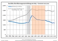
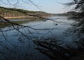
Lake Stechlin or Großer Stechlinsee is a lake in Landkreis Oberhavel, Brandenburg, Germany. At an elevation of 60 m, its surface area is 4.52 km2. The Stechlin cisco, a dwarfed fish, is found only in this lake. Theodor Fontane's last novel, Der Stechlin, was set in its vicinity.

Roofensee is a lake in Oberhavel, Brandenburg, Germany. It has a surface area of 0.56 km².

Blankenfelde is a locality (Ortsteil) located within the Berlin borough (Bezirk) of Pankow. Of the city's 95 localities, it is the least densely populated.

Lübars is a German locality (Ortsteil) within the borough (Bezirk) of Reinickendorf, Berlin.
Neuroofen is a small hamlet of around 25 people in the Stechlin district of Germany. It lies in the area between Menz and Altglobsow and is surrounded by the forests and lakes of the Furstenberg Conservation Area and the Stechlin-Ruppiner Land Nature Park.
The Rheinsberg Lake Region with its many great and small lakes, lies in the richly-varied, gently rolling, forested countryside between the villages of Rheinsberg, Menz and Fürstenberg/Havel in the north German state of Brandenburg. It lies just to the south of the Neustrelitz Little Lakes Region, but has no natural link to the waterbodies to the north. However, the Rheinsberg Lake Region is linked to the Neustrelitz lakes via the Wolfsbruch Canal and Lock, the Müritz-Havel Waterway and the Upper Havel Waterway. It drains southwards to the River Havel through the Rhin and is bounded by Ruppin Switzerland to the south. The overwhelming part of the region belongs to the Stechlin-Ruppiner Land Nature Park. The Stechlin Nature Reserve, created in 1938, is well known.