Kronsgaard

Last updated
Kronsgaard
DEU Kronsgaard COA.svg
Location of Kronsgaard within Schleswig-Flensburg district
Kronsgaard in SL.PNG
Germany adm location map.svg
Red pog.svg
Kronsgaard
Germany Schleswig-Holstein adm location map.svg
Red pog.svg
Kronsgaard
Coordinates: 54°43′52″N9°57′51″E / 54.73111°N 9.96417°E / 54.73111; 9.96417
Country Germany
State Schleswig-Holstein
District Schleswig-Flensburg
Municipal assoc. Geltinger Bucht
Government
   Mayor Wolfgang Kraack
Area
  Total5.92 km2 (2.29 sq mi)
Elevation
0 m (0 ft)
Population
 (2022-12-31) [1]
  Total247
  Density42/km2 (110/sq mi)
Time zone UTC+01:00 (CET)
  Summer (DST) UTC+02:00 (CEST)
Postal codes
24395
Dialling codes 04643
Vehicle registration SL
Website www.kronsgaard.de

Kronsgaard is a municipality in the district of Schleswig-Flensburg, in Schleswig-Holstein, Germany. Located near Geltinger Bucht, an inlet of the Baltic Sea in the Angeln region, the municipality is assigned to the Geltinger Bucht district. The village of Kronsgaard covers 592 hectares, has around 250 inhabitants and a coastline of around 3 kilometres with a popular natural beach at Pottloch.

Contents

Districts & Neighbouring Municipalities

The following districts comprise the municipality Breede (Danish: Brede), Boysenfeld (Boysensmark), Domstag (Dommedag), Düttebüll (Dyttebøl), Golsmaas (Galtmose, also Golsmose), Klorr, Langfeld (Langmark) and Pottloch (Puthul).

To the north and north-west lies the municipality of Pommerby, to the south and south-west the municipality of Hasselberg. The eastern border of Kronsgaard is defined by the Baltic Sea.

Coat of arms

"Against a blue background, a golden crown above a silver cross, whose crossbar ends in nail points and whose long bar ends in a ring with an eyelet at the top and a ball at the bottom." The coat of arms depicts the Kronsgaard death key. This is carried from house to house in the event of a death to inform the neighbours.

History

Kronsgaard was first mentioned as a farmstead in 1535, the name being a combination of the Danish Gaard or Gård for farm and Kron for crown, likely as a reference to the farmstead being in royal ownership. On a 16th century map by Marcus Jordanus, the place appears as Crongart. Local tradition has the original farm buildings being demolished and the stones being used as building material for the nearby Ohrfeld estate in Gelting. Initially, Kronsgaard belonged to the Buckhagen estate, later to the Düttebüll estate.

In 1922, the Antrax - a salvage steamer from the Mürwik torpedo station - sank off the coast near Kronsgaard. Twelve marines died. A memorial stone commemorating the loss of the Antrax can be seen near the Captain's House Sonwik in Mürwik Harbour.

Culture and places of interest

The Kronsgaard megalithic tomb (also called Smaahus) or Großsteingrab Kronsgaard was a Neolithic grave complex in Kronsgaard. The megalithic complex was associated with the Funnel Beaker Culture (TBK) and was built between 3500 and 2800 BC. The grave was located immediately west of the road intersection of Dorfstrasse and Jägerbucht; the lane that leads west from this intersection is called Smahuus, in recognition of the tomb's location. More precise information is only possible thanks to Pastor Jensen's description from 1838. Accordingly, it was probably a north-south oriented dolmen. The burial mound had a diameter of 30 paces (approx. 22.50 m), a height of 7 feet (approx. 2.15 m) and was framed in a circle by surrounding stones. The burial chamber consisted of five wall stones and two cover stones. The wall stones were divided into two support stones on the west side and one support stone on the east side as well as a cap stone in the south. The northern wall stone was found a little away from its original location. The chamber was 7 feet long (approx. 2.15 m) and 2 feet wide (approx. 0.65 m). It was wider at the floor than at the ceiling because the wall stones were at an angle. Ernst Sprockhoff lists the grave in his atlas of megalithic graves under number 35. [2]

Düttebüll Manor: The village of Düttebüll, which is now part of the municipality, was first mentioned in 1409. The first Düttebüll Manor was built in 1554 by Henneke von Rumohr as an aristocratic residence. Up until 1727, seven generations of the von Rumohr family owned the estate. The current manor house was considerably remodelled in 1785. In addition to the manor house, farm buildings, a bridge over the moat and an avenue of lime trees have been preserved. It is completely surrounded by a moat. The estate has been in the private ownership of the von Hobe family since 1902 and is not open to visitors.

Economy and transport

The municipality is characterised by agriculture and tourism, whereby tourism is particularly concentrated in the district of Golsmaas and at Pottloch on the Baltic Sea coast. The main part of Golsmaas consists of the DEW holiday village, which was built in 1965 and consists of more than 60 holiday homes. Kronsgaard has a natural beach at Pottloch, which is almost three kilometres long. During the summer season, Pottloch beach is guarded by the German Life Saving Association, which organises an annual summer festival.

Prominent Personalities

Christoph Ludwig Vollertsen - born in 1754 in Düttebüll; died in 1841 in Hütten, Protestant-Lutheran clergyman

Related Research Articles

<span class="mw-page-title-main">Flensburg</span> Independent town in Schleswig-Holstein, Germany

Flensburg is an independent town in the far north of the German state of Schleswig-Holstein. After Kiel and Lübeck, it is the third-largest town in Schleswig-Holstein.

<span class="mw-page-title-main">Anglia (peninsula)</span> Place in Schleswig-Holstein, Germany

Anglia is a small peninsula in northern Germany, on the Baltic coast of Jutland. Jutland consists of the mainland of Denmark and the northernmost German state of Schleswig-Holstein. Anglia belongs to the region of Southern Schleswig, which constitutes the northern part of Schleswig-Holstein. The region is often referred to in German as Landschaft Angeln or Halbinsel Angeln.

<span class="mw-page-title-main">Eckernförde</span> Town in Schleswig-Holstein, Germany

Eckernförde is a German town in Schleswig-Holstein, Kreis Rendsburg-Eckernförde, on the coast of the Baltic Sea approximately 30 km north-west of Kiel. The population is about 23,000. Eckernförde is a popular tourist destination in northern Germany.

<span class="mw-page-title-main">Aumühle</span> Municipality in Schleswig-Holstein, Germany

Aumühle is a municipality in Schleswig-Holstein in northern Germany, about 21 km (14 mi) east of Hamburg. Its Friedrichsruh district is home to the family estate and mausoleum of Otto von Bismarck.

<span class="mw-page-title-main">Als (island)</span> Danish island in the Baltic Sea

Als is a Danish island in the Baltic Sea.

<span class="mw-page-title-main">Bovenau</span> Municipality in Schleswig-Holstein, Germany

Bovenau is a village in the district of Rendsburg-Eckernförde, in the German state of Schleswig-Holstein. Bovenau is only 16 metres (52 ft) above sea level. The location is south of the municipality of Bünsdorf or Sehestedt, but north of Ostenfeld, Bredenbek, and west of Krummwisch, about 20 km (12 mi) away from the center of Kiel.

<span class="mw-page-title-main">Schönberg, Plön</span> Municipality in Schleswig-Holstein, Germany

Schönberg is a municipality in the district of Plön, in Schleswig-Holstein, Germany. It is situated on the Ostsee coast, approx. 17 km northeast of the state capital Kiel, and 26 km north of Plön. The formerly unincorporated town, became a part of the Probstei district on January 1, 2008, which already had its seat in Schönberg.

<span class="mw-page-title-main">Gelting</span> Municipality in Schleswig-Holstein, Germany

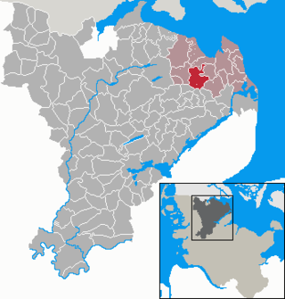
Gelting is a municipality in the district of Schleswig-Flensburg, in Schleswig-Holstein, Germany. It is situated near the Baltic Sea, approx. 33 km northeast of Schleswig, and 30 km east of Flensburg.

<span class="mw-page-title-main">Steinbergkirche</span> Municipality in Schleswig-Holstein, Germany

Steinbergkirche is a municipality in the district of Schleswig-Flensburg, in Schleswig-Holstein, Germany. It is situated near the Baltic Sea coast, approx. 30 km (19 mi) northeast of Schleswig, and 22 km (14 mi) east of Flensburg.

<span class="mw-page-title-main">Baltic German nobility</span> Historical upper class in the present-day countries of Estonia and Latvia

Baltic German nobility was a privileged social class in the territories of today's Estonia and Latvia. It has existed continuously since the Northern Crusades and the medieval foundation of Terra Mariana. Most of the nobility were Baltic Germans, but with the changing political landscape over the centuries, Polish, Swedish and Russian families also became part of the nobility, just as Baltic German families re-settled in locations such as the Swedish and Russian Empires. The nobility of Lithuania is for historical, social and ethnic reasons separated from the German-dominated nobility of Estonia and Latvia.

<span class="mw-page-title-main">Eckernförde Bay</span> Firth in the western Baltic Sea

Eckernförde Bay is a firth and a branch of the Bay of Kiel between the Danish Wahld peninsula in the south and the Schwansen peninsula in the north in the Baltic Sea off the lands of Schleswig-Holstein, Germany. The bay extends around 17 km (11 mi) deep into the land and is 10 km (6.2 mi) wide at its entrance where Booknis-Eck and Danish-Nienhof mark the endpoints. The bay is up to 28 m (92 ft) deep. The border to the Kiel Fjord lies at the Bülk Lighthouse. The once forested Danish Wahld peninsula between Kiel Fjord and Eckernförde Bay constituted the borderland between the Saxons and the Danes until the Middle Ages. At the inner end of the bay lies the town of Eckernförde.

<span class="mw-page-title-main">Gudow</span> Municipality in Schleswig-Holstein, Germany

Gudow is a municipality in the district of Lauenburg, in Schleswig-Holstein, Germany.

<span class="mw-page-title-main">Hohwacht</span> Municipality in Schleswig-Holstein, Germany

Hohwacht is a municipality in the district of Plön, in Schleswig-Holstein, Germany. It lies within the region of Wagria and its subordinate parishes are Hohwacht, Haßberg, Neudorf, Niedermühle and Schmiedendorf. The village was first mentioned in 1557 as Hohenwacht.

<span class="mw-page-title-main">Panker</span> Municipality in Schleswig-Holstein, Germany

Panker is a municipality in Plön county, Schleswig-Holstein, Germany.

<span class="mw-page-title-main">Esgrus</span> Municipality in Schleswig-Holstein, Germany

Esgrus is a municipality in the district of Schleswig-Flensburg, in Schleswig-Holstein, Germany.

<span class="mw-page-title-main">Glücksburg Castle</span> Renaissance schloss in Schleswig-Holstein

Glücksburg Castle is one of the most significant Renaissance castles in Northern Europe.

<span class="mw-page-title-main">Megaliths in Mecklenburg-Vorpommern</span>

In the area of present-day Mecklenburg-Vorpommern, Germany, up to 5,000 megalith tombs were erected as burial sites by people of the Neolithic Funnelbeaker (TRB) culture. More than 1,000 of them are preserved today and protected by law. Though varying in style and age, megalith structures are common in Western Europe, with those in Mecklenburg-Vorpommern belonging to the youngest and easternmost—further east, in the modern West Pomeranian Voivodeship of Poland, monuments erected by the TRB people did not include lithic structures, while they do in the south (Brandenburg), west and north (Denmark).

<span class="mw-page-title-main">Nordic megalith architecture</span> Ancient architectural style found in Northern Europe

Nordic megalith architecture is an ancient architectural style found in Northern Europe, especially Scandinavia and North Germany, that involves large slabs of stone arranged to form a structure. It emerged in northern Europe, predominantly between 3500 and 2800 BC. It was primarily a product of the Funnelbeaker culture. Between 1964 and 1974, Ewald Schuldt in Mecklenburg-Western Pomerania excavated over 100 sites of different types: simple dolmens, extended dolmens, passage graves, great dolmens, unchambered long barrows, and stone cists. In addition, there are polygonal dolmens and types that emerged later, for example, the Grabkiste and Röse. This nomenclature, which specifically derives from the German, is not used in Scandinavia where these sites are categorised by other, more general, terms, as dolmens, passage graves and stone cists.

<span class="mw-page-title-main">Simple dolmen</span> Early form of dolmen or megalithic tomb

The simple dolmen or primeval dolmen is an early form of dolmen or megalithic tomb that occurs especially in Northern Europe. The term was defined by archaeologist, Ernst Sprockhoff, and utilised by Ewald Schuldt in publicising his excavation of 106 megalithic sites in the north German state of Mecklenburg-Vorpommern. The simple dolmen emerged in the early days of the development of megalithic monuments of the Funnelbeaker culture (TBK) and around 3,500 BC they appeared across almost the entire region covered by the stone cult structures of Nordic megalith architecture, but not in the Netherlands, in Lower Saxony west of the River Weser nor east of the River Oder and only once in Sweden.

<span class="mw-page-title-main">Route of Megalithic Culture</span>

The Route of Megalithic Culture was first created as a tourist route that meanders from Osnabrück to Oldenburg in North-West Germany. Signposted with brown road signs it links many places of archaeological interest from the Megalithic era.

References

  1. "Bevölkerung der Gemeinden in Schleswig-Holstein 4. Quartal 2022" (XLS) (in German). Statistisches Amt für Hamburg und Schleswig-Holstein.
  2. Atlas der Megalithgräber Deutschlands, Teil I: Schleswig-Holstein. By Ernst Sprockhoff. Bonn: Rudolf Habelt Verlag, for Römisch-Germanische Kommission, 1966