Krøderen (village)

Last updated
Krøderen
Village
Kroderen stasjon.jpg
Krøderen Rail Station
Country Norway
Region Østlandet
County Buskerud
Municipality Krødsherad
Time zone UTC+01:00 (CET)
  Summer (DST) UTC+02:00 (CEST)
Post Code
3535

Krøderen is a village in Krødsherad, Buskerud, Norway.

Krødsherad Municipality in Buskerud, Norway

Krødsherad is a municipality in Buskerud county, Norway. The administrative centre of the municipality is the village of Noresund. The municipality of Krødsherad was established when it was separated from the municipality of Sigdal on 1 January 1901.

Buskerud County (fylke) of Norway

Buskerud is a county in Norway, bordering Akershus, Oslo, Oppland, Sogn og Fjordane, Hordaland, Telemark and Vestfold. The county extends from the Oslofjord and Drammensfjorden in the southeast to Hardangervidda mountain range in the northwest. The county administration is located in Drammen. Together with Akershus and Østfold, Buskerud will form the new, larger county Viken, from 1 January 2020.

Norway constitutional monarchy in Northern Europe

Norway, officially the Kingdom of Norway, is a Nordic country in Northern Europe whose territory comprises the western and northernmost portion of the Scandinavian Peninsula; the remote island of Jan Mayen and the archipelago of Svalbard are also part of the Kingdom of Norway. The Antarctic Peter I Island and the sub-Antarctic Bouvet Island are dependent territories and thus not considered part of the kingdom. Norway also lays claim to a section of Antarctica known as Queen Maud Land.

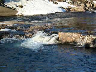
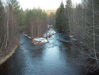
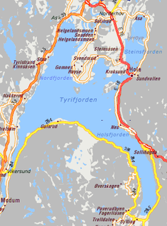
The village of Krøderen is located at the point where Snarumselva drains out of the south end of Lake Krøderen. Krøderen is approximately 100 km northwest of Oslo. Norwegian county road Fylkesvei 285 (Fv285) passes through the village, providing the shortest link between Hallingdal and Drammen. [1]

Krøderen (lake) lake in Flå and Krødsherad, Buskerud, Norway

Krøderen is a lake in the municipality of Krødsherad in Buskerud, Norway.

Oslo Place in Østlandet, Norway

Oslo is the capital and most populous city of Norway. It constitutes both a county and a municipality. Founded in the year 1040 as Ánslo, and established as a kaupstad or trading place in 1048 by Harald Hardrada, the city was elevated to a bishopric in 1070 and a capital under Haakon V of Norway around 1300. Personal unions with Denmark from 1397 to 1523 and again from 1536 to 1814 reduced its influence, and with Sweden from 1814 to 1905 it functioned as a co-official capital. After being destroyed by a fire in 1624, during the reign of King Christian IV, a new city was built closer to Akershus Fortress and named Christiania in the king's honour. It was established as a municipality (formannskapsdistrikt) on 1 January 1838. The city's name was spelled Kristiania between 1877 and 1897 by state and municipal authorities. In 1925 the city was renamed Oslo.

Norwegian county road highway in Norway

A Norwegian county road is a highway in Norway that is owned and maintained by the local county municipality. Some of the roads have road signs. The signs are white with black numbers.

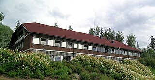
Since 1872, Krøderen Rail Station has been the terminus of the Krøder Line. Today this is a popular heritage railway which runs between Vikersund and Krøderen, a distance of about 26 km. [2] [3]

Vikersund Place

Vikersund is a town of 3,148 inhabitants in the municipality capital of Modum, in the county of Buskerud, Norway.

Related Research Articles

Sokna railway station in Ringerike, Norway

Sokna is a small village located between Hønefoss and Krøderen in the municipality of Ringerike, in the county of Buskerud, Norway. Its population is 543.

Sigdal Municipality in Buskerud, Norway

Sigdal is a municipality in Buskerud county, Norway. The administrative centre of the municipality is the village of Prestfoss.

Norefjell mountain in Norway

Norefjell is a mountain range in the Scandes Mountains system in Norway. It stretches between the valleys of Eggedal (west) and Hallingdal (east). It covers parts of the municipalities Flå, Sigdal, and Krødsherad, all in the county Buskerud.

Noresund

Noresund is a small village in Krødsherad in the county of Buskerud, Norway.

Lampeland village in Buskerud, Norway

Lampeland is a village located in Buskerud, Norway. It is the administrative centre of Flesberg municipality. The population of the village as of 2013 was 521 residents.

Veggli

Veggli is a village in the municipality of Rollag, in the county of Buskerud, Norway.

Skollenborg

Skollenborg is a small village in the municipality of Kongsberg in Buskerud county, Norway.

Sysle

Sysle is a village in the municipality of Modum, Buskerud county, Norway. Its population (2014) is 227.

Hallingdalselva river in Norway

Hallingdalselva is a river which flows through the valley and traditional district of Hallingdal in Buskerud County, Norway. Within the valley, the river is often referred to as the Great River (Storåne).

Vestbygda, Buskerud

Vestbygda is a village in the municipality of Ringerike in the county of Buskerud, Norway.

Nakkerud is a small village in Ringerike municipality, Buskerud, Norway. Its population is 350.

Steinsåsen

Steinsåsen is a village in Hole municipality in Buskerud, Norway. Steinsåsen located on the west side of Steinsfjorden, the eastern arm of Tyrifjorden. The village is about 9 km southeast of Honefoss. European route E16 passes through Steinsåsen as it travels from Oslo to Bergen.

Krøderen Line railway line in Norway

The Krøderen Line is a heritage railway line connecting the Krøderen lake in Buskerud, Norway, to the town of Vikersund. The 26-kilometre (16 mi) line was built as a narrow gauge branch line of the Randsfjord Line by the Norwegian State Railways (NSB) and opened in 1872. Passenger services were withdrawn in 1958, and freight traffic in 1985.

Tranby Place

Tranby is a village in Lier municipality in Buskerud, Norway. Tranby is located approximately 25 minutes drive southwest of Oslo and 10 minutes drive north of Drammen.

Gulsvik

Gulsvik is a village in the municipality of Flå in Buskerud, Norway. It is located in Hallingdal at the north end of Lake Krøderen.

Kaggefoss

Kaggefoss is a waterfall on the Snarumselva river in the municipality of Modum in Buskerud, Norway.

Venues of the 1952 Winter Olympics

The 1952 Winter Olympics were held in and around Oslo, Norway, from 14 to 25 February 1952. Ten competition and eight non-competition venues were used, in addition to three designated, but unused, reserve competition venues. Six of the competition venues were located in Oslo, while one each was located in Bærum, Skedsmo, Drammen and Krødsherad. Bislett stadion was the centerpiece of the games, hosting the opening and closing ceremonies, the speed skating and the figure skating. Bislett featured both a 400-meter (1,300 ft) circumference speed skating track and a 60-meter (200 ft) long rink used for figure skating, separated by snow banks. Two reserve venues were designated for the skating events, Tryvann stadion in Oslo and Hamar stadion in Hamar.

References

Coordinates: 60°09′N9°49′E / 60.150°N 9.817°E / 60.150; 9.817

Geographic coordinate system Coordinate system

A geographic coordinate system is a coordinate system that enables every location on Earth to be specified by a set of numbers, letters or symbols. The coordinates are often chosen such that one of the numbers represents a vertical position and two or three of the numbers represent a horizontal position; alternatively, a geographic position may be expressed in a combined three-dimensional Cartesian vector. A common choice of coordinates is latitude, longitude and elevation. To specify a location on a plane requires a map projection.