Nowy Kobrzyniec is a village in the administrative district of Gmina Rogowo, within Rypin County, Kuyavian-Pomeranian Voivodeship, in north-central Poland.
Lubrańczyk is a village in the administrative district of Gmina Lubraniec, within Włocławek County, Kuyavian-Pomeranian Voivodeship, in north-central Poland.
Wierzbica is a village in the administrative district of Gmina Leśniowice, within Chełm County, Lublin Voivodeship, in eastern Poland.

Łany is a village in the administrative district of Gmina Gościeradów, within Kraśnik County, Lublin Voivodeship, in eastern Poland. It lies approximately 4 kilometres (2 mi) south-west of Gościeradów, 20 km (12 mi) south-west of Kraśnik, and 62 km (39 mi) south-west of the regional capital Lublin.

Ciechanki-Kolonia is a village in the administrative district of Gmina Puchaczów, within Łęczna County, Lublin Voivodeship, in eastern Poland. It lies approximately 3 kilometres (2 mi) south of Puchaczów, 7 km (4 mi) east of Łęczna, and 28 km (17 mi) east of the regional capital Lublin.

Teofilów is a village in the administrative district of Gmina Tarłów, within Opatów County, Świętokrzyskie Voivodeship, in south-central Poland. It lies approximately 9 kilometres (6 mi) south-west of Tarłów, 23 km (14 mi) north-east of Opatów, and 71 km (44 mi) east of the regional capital Kielce.

Cieśle is a village in the administrative district of Gmina Krasocin, within Włoszczowa County, Świętokrzyskie Voivodeship, in south-central Poland. It lies approximately 8 kilometres (5 mi) south-east of Krasocin, 17 km (11 mi) east of Włoszczowa, and 30 km (19 mi) west of the regional capital Kielce.
Żabin Karniewski is a village in the administrative district of Gmina Karniewo, within Maków County, Masovian Voivodeship, in east-central Poland.
Giewartów-Holendry is a village in the administrative district of Gmina Ostrowite, within Słupca County, Greater Poland Voivodeship, in west-central Poland.
Lipinka is a village in the administrative district of Gmina Dobiegniew, within Strzelce-Drezdenko County, Lubusz Voivodeship, in western Poland.
Kosin is a village in the administrative district of Gmina Drezdenko, within Strzelce-Drezdenko County, Lubusz Voivodeship, in western Poland.

Błotnica is a village in the administrative district of Gmina Stare Kurowo, within Strzelce-Drezdenko County, Lubusz Voivodeship, in western Poland. It lies approximately 3 kilometres (2 mi) east of Stare Kurowo, 11 km (7 mi) east of Strzelce Krajeńskie, and 32 km (20 mi) north-east of Gorzów Wielkopolski.

Nowa Juńcza is a settlement in the administrative district of Gmina Czersk, within Chojnice County, Pomeranian Voivodeship, in northern Poland. It lies approximately 6 kilometres (4 mi) north of Czersk, 34 km (21 mi) north-east of Chojnice, and 72 km (45 mi) south-west of the regional capital Gdańsk.

Tklania is a settlement in the administrative district of Gmina Dziemiany, within Kościerzyna County, Pomeranian Voivodeship, in northern Poland. It lies approximately 5 kilometres (3 mi) south of Dziemiany, 21 km (13 mi) south-west of Kościerzyna, and 71 km (44 mi) south-west of the regional capital Gdańsk.

Śpigiel is a village in the administrative district of Gmina Reszel, within Kętrzyn County, Warmian-Masurian Voivodeship, in northern Poland. It lies approximately 11 kilometres (7 mi) south-east of Reszel, 17 km (11 mi) south-west of Kętrzyn, and 52 km (32 mi) north-east of the regional capital Olsztyn.
Zgnilec is a settlement in the administrative district of Gmina Myślibórz, within Myślibórz County, West Pomeranian Voivodeship, in north-western Poland.
Tamsi is a village in Järva Parish, Järva County in northern-central Estonia.

Toplac is a village in the municipality of Vranje, Serbia. According to the 2002 census, the village has a population of 519 people.

Verrijn Stuartweg is an Amsterdam Metro station in Diemen, Netherlands.

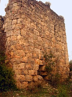
Kuzucubelen Castle is a castle ruin in Mersin Province, Turkey.


