
Sringeri also called Shringeri is a hill town and Taluk headquarters located in Chikkamagaluru district in the Indian state of Karnataka. It is the site of the first maṭha established by Adi Shankara, Hindu theologian and exponent of the Advaita Vedanta philosophy. Located on the banks of the river Tungā, the town draws a large number of pilgrims to its temples of Sri Sharadamba, Sri Vidyashankara, Sri Malahanikareshvara and other deities.

Sathyamangalam is a town and municipality in Erode district in the Indian state of Tamil Nadu. It lies on the banks of the Bhavani river, a tributary of the Cauvery in the foothills of the Western Ghats and is the headquarters of Sathyamangalam taluk. It is about 65 km from Erode, 58 km from Tiruppur and 65 km from Coimbatore. As of 2011, the town had a population of 37,816.
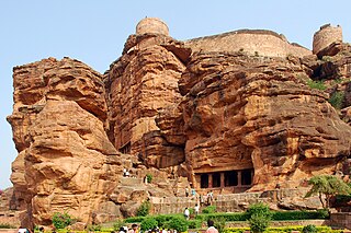
Badami, formerly known as Vātāpi, is a town and headquarters of a taluk by the same name, in the Bagalkot district of Karnataka, India. It was the regal capital of the Badami Chalukyas from 540 to 757. It is famous for its rock cut monuments such as the Badami cave temples, as well as the structural temples such as the Bhutanatha temples, Badami Shivalaya and Jambulingesvara Temple. It is located in a ravine at the foot of a rugged, red sandstone outcrop that surrounds Agastya lake.
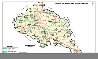
Shahapur is a city and taluka headquarter located in the Yadgir district of Indian state of Karnataka. Shahapur is 597 km north of Bangalore and well connected by road to Gulbarga (70 km), Hyderabad (240 km), Bidar (160 km), Raichur (90 km) and Yadgir (32 km).

Devanahalli, also called "Devandahalli", "Dyaavandalli", Devanadoddi, and Devanapura, is a town and Town Municipal Council in Bengaluru Rural district in the state of Karnataka in India. The town is located 40 kilometres (25 mi) to the north-east of Bengaluru. Devanahalli is the site of Kempegowda International Airport. A multibillion-dollar Devanahalli Business Park with two IT Parks are coming up on nearly 400 acres (1.6 km2) adjoining the airport. An Aerospace Park, Science Park and a ₹10 billion (US$120 million) Financial City are also coming up. A new satellite ring road will connect the city with Doddaballapur. Devanahalli is situated near the upcoming ₹1,500 billion (US$18 billion), 12,000-acre (49 km2) BIAL IT Investment Region, to be the largest IT region in India.

Chamarajanagara is a city and headquarter of eponymous Chamarajanagar district in the Karnataka state of India. It is named after Chamaraja Wodeyar IX, the erstwhile Raja of Mysore, Chamarajanagara was previously known as 'Arikottara'.
Kanakapura is a city in the Ramanagara district of Karnataka on the banks of the Arkavathi river and the administrative center of the taluk of the same name. Its founder is Shrihan Kanaka Sigmanath, hence its name. Kanakapura is largest cocoon silk producer in India. River Cauvery flows around 21 km in Kanakapura Taluk.Previously belonged to Bangalore Rural District. It was formerly the largest constituency in the country. (1,553 km2 [600 sq mi]). It is located among the lush green forests of the state of Karnataka. The town is infamous with the traffic of Kanakpura Road in Benglaluru, one of the most narrow and traffic-prone roads of the state. The town is a tourism hotspot and an often visited tourist favorite in the entire state of Karnataka, as it has something for everyone ranging from avid trekkers to history buffs and wildlife enthusiasts. The forest area in this taluk is very wide and about half of the Bannerghatta National Park is located in our Kanakapura area. Kodihalli wildlife range and harohalli wildlife range its division. The Kaveri Wildlife Sanctuary consists of two main zones namely the Sangam Wildlife range, the Muggur Wildlife range.
Gangavathi is a city, municipality and taluk in the Koppal district of the Indian state of Karnataka. It is one of the main commercial hubs in the Kalyana-Karnataka region. It is also the largest city, in terms of area and population, in the Koppal district.
Harapanahalli is a small city, taluk and sub-divisional headquarter in Vijayanagara District in the Indian state of Karnataka.

Hindupuram is the largest city in Sri Sathya Sai district of the Indian state of Andhra Pradesh. It is located to the edge of the Andhra–Karnataka border and is the headquarters of Hindupuram mandalam. Hindupuram is the Parliamentary Constituency in the newly formed District Sri Sathya Sai. It is located about 619 km from Amaravati the capital of Andhra Pradesh, 67 km from district headquarters Puttaparthi, 100 km from Bengaluru the capital of Karnataka, 95 km From Kadiri.
Hoovina Hadagali or Huvina Hadagali is a town and a taluk in the Vijayanagara district of Karnataka, India. It is the administrative headquarters of the HuvinaHadagali Taluk.

Malavalli is a town and a taluka in Mandya district in the Indian state of Karnataka. Malavalli town in history is quoted dates back to 27 March 1799 - Fourth Anglo Mysore War. Battle of Malavalli was fought between Tippu Sultan's Mysore Army against the British East India Company led by Arthur Wellesley. The men from the town fought fiercely and laid down their lives.
Mundgod is a town in Uttara Kannada district of Karnataka state in India, Mundgod is renowned for its extensive cultivation of rice.
Siruguppa is a town and headquarters of the Siruguppa taluk and second largest city in Ballari district after Hospete carved out of Ballari district of Indian state of Karnataka.
Terdal is a Municipal town in Bagalkot district in the Indian state of Karnataka.

Tirumakudalu Narasipura the temple city of Karnataka, commonly known as T. Narasipura or T.N. Pura, is a town in Mysore district in the Indian state of Karnataka. The first name refers to the land at the confluence, (trimakuta in Sanskrit at the confluence of the Kaveri, Kabini and Spatika Sarovara. The city is a Taluk of Mysore district and 32 km south-east of the district headquarters and has five Hobli centers. This taluk is bordered by Chamarajanagar district to the south and Mandya districts to the north with an area of 598 sq km. Agriculture is the main occupation of the people here. Rice is the main food crop and silk is the main commercial crop. Fossils of Neolithic age have been found by excavation in some lands of this Taluk. Vyasatirtha, the guru of Purandara Dasa, and T Chowdiah, the unique violinist, were born in this Taluk. Talakad, the capital of the Western Ganga dynasty, is in this Taluk.
Yalaburga also called Yelburga is a panchayat town in Koppal district in the Indian state of Karnataka.
Uttangi is a village in the southern state of Karnataka, India. It is located in the Hadagalli taluk of Vijayanagara district in Karnataka.
Belagere is a village in Challakere, Chitradurga district, Karnataka, India. It is located on the left bank of Vedavati River. According to the 2011 census of India, there was a population of 2769 people . n Belagere village population of children with age 0-6 is 251 which makes up 9.06% of total population of village. Average Sex Ratio of Belagere village is 898 which is lower than Karnataka state average of 973. Child Sex Ratio for the Belagere as per census is 806, lower than Karnataka average of 948.

Vijayanagara district is a district in the southern Indian state of Karnataka, located in the Kalyana-Karnataka region.
