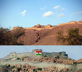
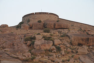
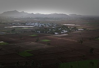
Gallery
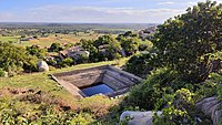 Kalyani at Gudekote fort
Gudekote is a village in Kudligi taluk in Vijayanagara district in the Indian state of Karnataka.
It is about 270 km from the state capital of Bangalore and 54 km from the city of Ballari. It was part of the Madras State and transferred to Karnataka after the formation of new states.
Legend says that Gudekote was ruled by a king called Banasura, who was an ardent devotee of Lord Shiva and Goddess Parvati. [1] Impressed by his devotion, the divine couple assured him that they would guard the village for eternity. The village was then the size of a city, and was known by the name of its ruler.
British geologist and archaeologist Bruce Foote claimed that the boulders here are so huge, that he hadn't seen any of this size, in all of South India. [1] Gude, in Kannada, is literally translated to a heap or a group. Gudekote is surrounded by hills with huge boulders. The fort (kote, in Kannada) is situated on top of one such rocky hill and possibly gave the name Gudekote to this village. [1]
The ruins in and around the village date to prehistoric times. Stone age weapons and delicate ruins have been found in caves and by the sides of boulders, in Appayaganahalli, Panchalingeshwara, Doregudda and other places.
Gudekote was once Mauryan rule, indicated by edicts in nearby Brahmagiri and Siddapura. Satavahana edicts have also been found in nearby Kottur, Kudligi, Shivapura, Choranur, Molakalmuru, Ashoka Siddapura and other places.
It was later ruled by Badami and Kalyana Chalukyas, Rashtrakutas, and saw some development under the rule of Hoysalas and the kings of Hosamanedurga.
Under the Vijayanagar empire, Gudekote was an important administrative centre of the palegars, who ruled for nearly 250 years. [1] Gundalanayaka was the first palegar of Gudekote, along with Bommantaraja, Chinnayyaraja, Immadi Rajappanayaka, Jattingaraja and Shivappanayaka. [1] Toward the end of the 18th century, Hyder Ali and Tipu Sultan captured Gudekote, which went back to the palegars after Tipu lost to the British in 1792. It was transferred to the Nizams in 1799, and then to the British in 1800, and joined Mysore State in 1947.
It is believed that one of Karnataka's brave woman warriors, Onake Obavva, daughter of Chalavadi Chinnapa, was born in Gudekote.


Raichur District is an administrative district in the Indian state of Karnataka. It is located in the northeast part of the state and is bounded by Yadgir district in the north, Bijapur and Bagalkot district in the northwest, Koppal district in the west, Bellary district in the south, Jogulamba Gadwal district of Telangana and Kurnool district of Andhra Pradesh in the east.
Ballari in the eponymous Ballari district, is a city in the state of Karnataka, India.

The Tungabhadra River starts and flows through the state of Karnataka, India, during most of its course, Andhra Pradesh and ultimately joining the Krishna River near Murvakonda in Andhra Pradesh.

North Karnataka is a geographical region in Deccan plateau from 300 to 730 metres elevation that constitutes the region of the Karnataka state in India and the region consists of 14 districts. It is drained by the Krishna River and its tributaries the Bhima, Ghataprabha, Malaprabha, and Tungabhadra. North Karnataka lies within the Deccan thorn scrub forests ecoregion, which extends north into eastern Maharashtra.

Chitradurga is a city and the headquarters of Chitradurga district, which is located on the valley of the Vedavati river in the central part of the Indian state of Karnataka. Chitradurga is a place with historical significance which is located to the North West about 200 km from the state capital Bangalore. Chitradurga is a major tourist hub in Karnataka.
Harapanahalli is a town, taluk and is one of the two sub-divisional headquarter in the Vijayanagara District in the Indian state of Karnataka.
Molakalmuru is a taluk in Chitradurga district in the Indian state of Karnataka. It is near the border of Karnataka and Andhra Pradesh. It borders the Rayadurg taluk of Ananthpur district of Andhra Pradesh. Legend has it that its name means "broken knees" in Kannada, referencing a battle between the native Indians and the British in which, due to the rocky and hilly terrain, British soldiers suffered many broken knees in their defeat. The town is famous for the unique Molkalmuru sarees manufactured here.
Siruguppa is a town and headquarters of the Siruguppa taluk and second largest city in Ballari district after Hospete carved out of Ballari district of Indian state of Karnataka.
Tekkalakote, also known as Tekkalakota, is a Panchayat town and Pre-historic Neolithic site in Siruguppa taluk of Ballari district in the Indian state of Karnataka.

Ballari, formerly Bellary, is a major district in Karnataka. It is located at north-eastern part of Karnataka. This district belongs to Kalyana-Karnataka. This district was one of the biggest districts in Karnataka until the Vijayanagara district was carved out of Ballari district in 2021 officially.

Karnataka, the sixth largest state in India, has been ranked as the third most popular state in the country for tourism in 2014. It is home to 507 of the 3600 centrally protected monuments in India, second only to Uttar Pradesh. The State Directorate of Archaeology and Museums protects an additional 752 monuments and another 25,000 monuments are yet to receive protection.

Chitradurga Fort, or as the British called it Chitaldoorg, is a fortification that straddles several hills and a peak overlooking a flat valley in the Chitradurga District, Karnataka, India. The fort's name Chitrakaldurga, which means 'picturesque fort' in Kannada, is the namesake of the town Chitradurga and its administrative district.

Skandagiri, also known as Kalavara Durga, is a mountain fortress located approximately 62 km (39 mi) from Bangalore city, and 3 km (1.9 mi) from Chikballapur in the Indian state of Karnataka. It is off Bellary Road, and overlooks Nandi Hills and Muddenahalli. The peak is at an altitude of about 1,450 m (4,760 ft). It is accessed from Kalavara village, which has a population of, 1093 according to 2011 census. The hill features the ruins of a fort believed to have been built by Tipu Sultan, the ruler of the Kingdom of Mysore. It was used as a military stronghold and lookout point.
The Bellary Fort was built on top of a hill called the "Ballari Gudda" or the Fort Hill. It is situated in the historic city of Bellary, in the Bellary district, in Karnataka state, India. It was built in two parts namely, the Upper Fort and the Lower Fort. The Upper Fort was built by Hanumappa Nayaka, a feudatory of Vijayanagara Empire, but the Lower Fort was built by Hyder Ali in later part of the 18th century.
Kenchanagudda is a village in the southern state of Karnataka, India. The village is located in the Siruguppa taluk of Ballari district.
Ballari pronounced is a historic city in Bellary district in Karnataka state, India.
Karatagi is a town and taluk headquarters of Karatagi taluk and it is located in Koppal District in Karnataka, India. It is one of the most important commercial centres in the district. The town is made up of multiple paddy fields, which are irrigated by the Tungabhadra Canal. Karatagi is known for its numerous rice mills, which can be found in the town and the surrounding areas.
Bellary Nala is a river of southern India. It rises in the Yellur in Belgaum Taluk of Karnataka state, flows towards South-eastern side of the Belagavi city and flows through Halga, Vadgaon, Shahapur, Bastwad, Basavan Kudchi, Angol, Mutga, Sambra, Muchandi, Sulebhavi Khangaon, Hudali, Suldhal, Malamaradi, Budihal, Ankalgi, Akkatangerahal, Kundargi and many villages before reaching its confluence into the Markandeya river at near Karaguppi in Hukkeri Taluk

Vijayanagara district is a district in the southern Indian state of Karnataka, located in the Kalyana-Karnataka region.
| | This article related to a location in Vijayanagara district, Karnataka, India is a stub. You can help Wikipedia by expanding it. |