Related Research Articles

Stonycreek Township is a township in Cambria County, Pennsylvania, United States. The population was 2,844 at the 2010 census, down from 3,204 at the 2000 census. It is part of the Johnstown, Pennsylvania Metropolitan Statistical Area.

In geomorphology and geology, a peneplain is a low-relief plain formed by protracted erosion. This is the definition in the broadest of terms, albeit with frequency the usage of peneplain is meant to imply the representation of a near-final stage of fluvial erosion during times of extended tectonic stability. Peneplains are sometimes associated with the cycle of erosion theory of William Morris Davis, but Davis and other workers have also used the term in a purely descriptive manner without any theory or particular genesis attached.

The St. Croix River is a river in northeastern North America, 71 miles (114 km) in length, that forms part of the Canada–United States border between Maine (U.S.) and New Brunswick (Canada). The river rises in the Chiputneticook Lakes and flows south and southeast, between Calais and St. Stephen. It discharges into Passamaquoddy Bay, in the Bay of Fundy.

In geology and geomorphology a base level is the lower limit for an erosion process. The modern term was introduced by John Wesley Powell in 1875. The term was subsequently appropriated by William Morris Davis who used it in his cycle of erosion theory. The "ultimate base level" is the plane that results from projection of the sea level under landmasses. It is to this base level that topography tends to approach due to erosion, eventually forming a peneplain close to the end of a cycle of erosion.
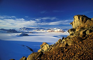
The Transantarctic Mountains comprise a mountain range of uplifted rock in Antarctica which extend, with some interruptions, across the continent from Cape Adare in northern Victoria Land to Coats Land. These mountains divide East Antarctica and West Antarctica. They include a number of separately named mountain groups, which are often again subdivided into smaller ranges.

The Nimrod Glacier is a major glacier about 135 km (85 mi) long, flowing from the polar plateau in a northerly direction through the Transantarctic Mountains between the Geologists and Miller Ranges, then northeasterly between the Churchill Mountains and Queen Elizabeth Range, and finally spilling into Shackleton Inlet and the Ross Ice Shelf between Capes Wilson and Lyttelton.

The Horlick Mountains are a mountain range in the Transantarctic Mountains of Antarctica. Some sources indicate that the designation includes the Ohio Range, the Long Hills, and all of the Wisconsin Range, while others suggest that it includes only the eastern portion of the Queen Maud Mountains and the main body of the Wisconsin Range. At one point the designation also included the Thiel Mountains.

West Antarctica, or Lesser Antarctica, one of the two major regions of Antarctica, is the part of that continent that lies within the Western Hemisphere, and includes the Antarctic Peninsula. It is separated from East Antarctica by the Transantarctic Mountains and is covered by the West Antarctic Ice Sheet. It lies between the Ross Sea, and the Weddell Sea. It may be considered a giant peninsula, stretching from the South Pole towards the tip of South America.

Oligodon is genus of colubrid snakes that was first described by the Austrian zoologist Fitzinger in 1826. This genus is widespread throughout central and tropical Asia.

The geology of Antarctica covers the geological development of the continent through the Archean, Proterozoic and Phanerozoic eons.

The Hanson Formation is a geologic formation on Mount Kirkpatrick, Antarctica. It is one of only two major dinosaur-bearing rock groups found on the continent of Antarctica to date; the other is the Snow Hill Island Formation and related formations from the Late Cretaceous of the Antarctic Peninsula. The formation has yielded only a handful of Mesozoic specimens so far and most of it is as yet unexcavated. Part of the Victoria Group of the Transantarctic Mountains, it is below the Prebble Formation and above the Falla Formation. The Formation is related to the Volcanic Activity Linked to the Karoo-Ferar eruptions on the Lower Jurassic. The climate of the zone was similar to the modern Southern Chile, Humid, with a temperature interval of 17–18 degrees.

Mount Carleton Provincial Park, established in 1970, is the largest provincial park in the Province of New Brunswick, Canada. It encompasses 174 square kilometres (67 sq mi) in the remote highlands of north-central New Brunswick. The park is a lesser-known gem of the Atlantic Canadian wilderness. Some outdoor enthusiasts refer to it as the "Algonquin of New Brunswick."

Glacialisaurus is a genus of massospondylid sauropodomorph dinosaur. It lived during the Early Jurassic period in what is now central Transantarctic Mountains of Antarctica. It is known from the holotype FMNH PR1823, a partial hind limb (foot) and from the referred material FMNH PR1822, a left femur.

The Laurentian Upland is a physiographic region which, when referred to as the "Laurentian Region" or the Grenville geological province, is recognized by Natural Resources Canada as one of five provinces of the larger Canadian Shield physiographic division. The United States Geological Survey recognizes the Laurentian Upland as the larger general upland area of the Canadian Shield.
The Beacon Supergroup is a geological formation exposed in Antarctica and deposited from the Devonian to the Triassic. The unit was originally described as either a formation or sandstone, and upgraded to group and supergroup as time passed. It contains a sandy member known as the Beacon heights orthoquartzite.

The tectonic evolution of the Transantarctic Mountains appears to have begun when Antarctica broke away from Australia during the late Cretaceous and is ongoing, creating along the way some of the longest mountain ranges formed by rift flank uplift and associated continental rifting. The Transantarctic Mountains (TAM) separate East and West Antarctica. The rift system that formed them is caused by a reactivation of crust along the East Antarctic Craton. This rifting or seafloor spreading causes plate movement that results in a nearby convergent boundary which then forms the mountain range. The exact processes responsible for making the Transantarctic Mountains are still debated today. This results in a large variety of proposed theories that attempt to decipher the tectonic history of these mountains.

The East Antarctic Shield or Craton is a cratonic rock body that covers 10.2 million square kilometers or roughly 73% of the continent of Antarctica. The shield is almost entirely buried by the East Antarctic Ice Sheet that has an average thickness of 2200 meters but reaches up to 4700 meters in some locations. East Antarctica is separated from West Antarctica by the 100–300 kilometer wide Transantarctic Mountains, which span nearly 3,500 kilometers from the Weddell Sea to the Ross Sea. The East Antarctic Shield is then divided into an extensive central craton that occupies most of the continental interior and various other marginal cratons that are exposed along the coast.

The South Swedish highlands or South Swedish Uplands is a hilly area covering large parts of Götaland in southern Sweden. Except for a lack of deep valleys, the landscape is similar to the Norrland terrain found further north in Sweden. The central-eastern parts of the highlands contain about thirty narrow canyons locally known as skurus.
Wilkinson Mountain is a summit in northern Wayne County in the U.S. state of Missouri. The peak has an elevation of 735 feet (224 m). The peak lies south of Coldwater and U.S. Route 67 passes to the northwest.
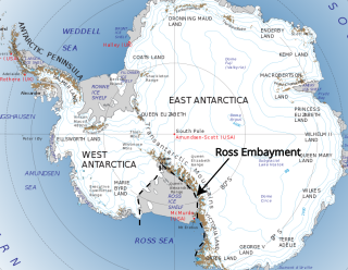
The Ross Embayment is a large region of Antarctica, comprising the Ross Ice Shelf and the Ross Sea, that lies between East and West Antarctica.
References
- ↑ Fitzgerald, Paul G.; Sandiford, Michael; Barrett, Peter J.; Gleadow, Andrew J. D. (1986). "Asymmetric extension associated with uplift and subsidence in the Transantarctic Mountains and Ross Embayment". Earth and Planetary Science Letters . 81: 67–78. Bibcode:1986E&PSL..81...67F. doi:10.1016/0012-821x(86)90101-9.
Coordinates: 84°52′43″S174°17′50″W / 84.87861°S 174.29722°W
 | This Antarctica-related article is a stub. You can help Wikipedia by expanding it. |
| This geology article is a stub. You can help Wikipedia by expanding it. |