
The Gambia, officially the Republic of The Gambia, is a country in West Africa. It is the smallest country within mainland Africa and is surrounded by Senegal, except for its western coast on the Atlantic Ocean. The Gambia is situated on both sides of the lower reaches of the Gambia River, the nation's namesake, which flows through the centre of the Gambia and empties into the Atlantic Ocean. It has an area of 10,689 square kilometres (4,127 sq mi) with a population of 1,857,181 as of the April 2013 census. Banjul is the Gambian capital and the country's largest metropolitan area. The largest cities are Serekunda and Brikama.
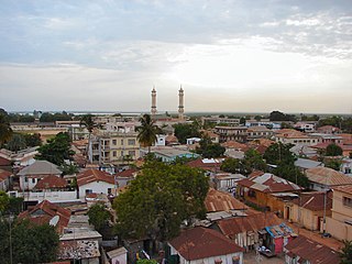
Banjul, officially the City of Banjul, is the capital and fourth largest city of The Gambia. It is the centre of the eponymous administrative division which is home to an estimated 400,000 residents, making it The Gambia's largest and most densely populated metropolitan area. Banjul is on St Mary's Island, where the Gambia River enters the Atlantic Ocean. The population of the city proper is 31,301, with the Greater Banjul Area, which includes the City of Banjul and the Kanifing Municipal Council, at a population of 413,397. The island is connected to the mainland to the west and the rest of Greater Banjul Area via bridges. There are also ferries linking Banjul to the mainland at the other side of the river.

The demographic characteristics of the population of the Gambia are known through national censuses, conducted in ten-year intervals and analyzed by The Gambian Bureau of Statistics (GBOS) since 1963. The latest census was conducted in 2013. The population of The Gambia at the 2013 census was 1.8 million. The population density is 176.1 per square kilometer, and the overall life expectancy in The Gambia is 64.1 years. Since the first census of 1963, the population of The Gambia has increased every ten years by an average of 43.2 percent. Since 1950s, the birth rate has constantly exceeded the death rate; the natural growth rate is positive. The Gambia is in the second stage of demographic transition. In terms of age structure, The Gambia is dominated by 15- to 64-year-old segment (57.6%). The median age of the population is 19.9 years, and the gender ratio of the total population is 0.98 males per female.

Ardencroft is a village in New Castle County, Delaware, United States. According to the 2010 Census, the population of the village is 231.
Hillside is a village in Cook County, Illinois, United States. As of the 2010 census it had a population of 8,157.

Hoffman Estates is a village in Illinois, United States. The village is located primarily in Cook County, with a small section in Kane County. It is a suburb of Chicago. As of the 2010 census, the population was 51,895, and as of 2019 the estimated population was 50,932.
Justice is a village in Cook County, Illinois, United States, established in 1911. The population was 12,926 as of the 2010 census.

Streamwood is a village in Cook County, Illinois, United States. The population was 39,858 at the 2010 census. It is a northwest suburb of Chicago, and is a part of the Chicago metropolitan area.
Huntley is a village in McHenry and Kane counties, Illinois, United States. As of the 2010 census it had a population of 24,291, and as of 2019 the estimated population was 27,228. It is a part of the Chicago metropolitan area.

Pelham Manor is an affluent village located in Westchester County, New York, United States. As of the 2010 census, the village had a total population of 5,486. It is located in the town of Pelham.

Bakau is a town on the Atlantic coast of Gambia, west of Gambia's capital city of Banjul. It is known for its botanical gardens, its crocodile pool Bakau Kachikally and for the beaches at Cape Point. Bakau is the first major suburb outside Banjul and the most developed town in the Gambia. Close to Bakau and Banjul is Gambia's largest city, Serekunda.

Buxar district is one of the 38 districts of Bihar, India. Located in the southwestern part of the state, it is a primarily agricultural district. The district headquarters is at the town of Buxar.

Surendranagar is an administrative district in Saurashtra region of Gujarat state in India. It has a population of approximately 1.7 million people. Surendranagar city, along with the twin city of Wadhwan, has a total of 400,000 inhabitants, and is known as "Camp".

Hazaribagh district is one of the twenty-four districts of Jharkhand state, India and the district headquarter located in Hazaribagh town. It is currently a part of the Red Corridor.
Bhind district is a district in the Chambal division of the Indian state of Madhya Pradesh. The town of Bhind is the district headquarters. Bhind District is situated in Chambal region in the northwest of the state. It is bounded by Agra, Etawah, Jalaun and Jhansi districts of Uttar Pradesh state to the north and the east, and the Madhya Pradesh districts of Datia to the south, Gwalior to the southwest, and Morena to the west. The geography of the district is characterised by uneven ravines, plain fertile fields and scanty forests. The total area of the district is 4,459 km2 (1,722 sq mi).

Cart Road is a census town in the Kurseong CD block in the Kurseong subdivision of the Darjeeling district in the state of West Bengal, India.

Kupwara is a city and a municipal council in Kupwara district in the Indian administered union territory of Jammu and Kashmir.

Karadka is a Village, Block Panchayat and Grama Panchayat in Kasaragod district in the state of Kerala, India.
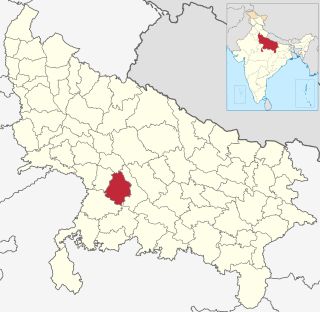
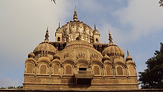
Kanpur Dehat district is a district in Uttar Pradesh state in northern India. The administrative headquarters of the district are at Mati-Akbarpur. This district is part of Kanpur division. Kanpur was formerly spelled Cawnpore.
The Gambian Creole people, or Krio or Aku, are a minority ethnic group of Gambia with connections to and some roots from the Sierra Leone Creole people. In Gambia the Aku account for about 2% of the population. Some estimates put the figure higher. However, according to the 2013 Gambian Census, the Aku make up 0.5% of the population or around 8,477 people.