Related Research Articles

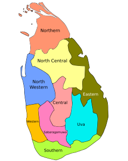
In Sri Lanka, provinces are the first level administrative division. They were first established by the British rulers of Ceylon in 1833. Over the next century most of the administrative functions were transferred to the districts, the second level administrative division. By the middle of the 20th century the provinces had become merely ceremonial. This changed in 1987 when, following several decades of increasing demand for a decentralization, the 13th Amendment to the 1978 Constitution of Sri Lanka established provincial councils. Currently there are nine provinces.

Uva Province is Sri Lanka's second least populated province, with 1,259,880 people, created in 1896. It consists of two districts: Badulla and Moneragala. The provincial capital is Badulla. Uva is bordered by the Eastern, Southern, Sabaragamuwa, and Central provinces. Its major tourist attractions are Dunhinda falls, Diyaluma Falls, Rawana Falls, the Yala National Park and Gal Oya National Park. The Gal Oya hills and the Central mountains are the main uplands, while the Mahaweli and Menik rivers and the huge Senanayake Samudraya and Maduru Oya Reservoirs are the major waterways.

The Eastern Province is one of the nine provinces of Sri Lanka, the first level administrative division of the country. The provinces have existed since the 19th century but did not have any legal status until 1987 when the 13th Amendment to the Constitution of Sri Lanka established provincial councils. Between 1988 and 2006 the province was temporarily merged with the Northern Province to form the North Eastern Province. The capital of the province is Trincomalee.

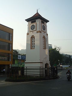
Badulla is the capital and the largest city of Uva Province situated in the lower central hills of Sri Lanka. It is the capital city of Uva Province and the Badulla District.

Badulla District is a district in Uva Province, Sri Lanka. The entire land area of the Badulla district is 2,861 km2 (1,105 sq mi) and has a total population of 837,000. The district is bounded by the districts of Monaragala and Rathnapura on the east and south, by Ampara and Kandy districts to the north and by Nuwara Eliya and Matale to the west. Mainly the economy of the district is based on agricultural farming and livestock.

Ceylon was the British Crown colony of present-day Sri Lanka between 1796 and 4 February 1948. Initially, the area it covered did not include the Kingdom of Kandy, which was a protectorate, but from 1817 to 1948 the British possessions included the whole island of Ceylon, now the nation of Sri Lanka.

Christianity is a minority religion in Sri Lanka. It was introduced to the island in first century, probably in AD 72. Traditionally, after Thomas the Apostle's visit in Kerala in AD 52, Christianity is said to have been introduced to Sri Lanka because of its close geographical and commercial ties.
Monaragala is a town located in Monaragala District, Uva Province, Sri Lanka. It is the largest town in Monaragala District and is located 57.3 km (35.6 mi) southeast of Badulla, the capital city of Uva Province. Monaragala is situated about 151 m (495 ft) above sea level on the Colombo-Batticaloa main road.
Keppetipola (කැප්පෙටිපොල) is a town in Sri Lanka. It is located in Badulla District of Uva Province, Sri Lanka. During the British period this village had been called as Wilson-Tenna. In 1818 the British General named Wilson destroyed and abandoned this arid. Then this was called Palugama. And later somewhere in 1968 this had been named as Keppetipola. This had been done in honour and to commemorate the action of Monarawila keppetipola's return of the British troops and Armour and joining and taking the leadership of the 1818 rebellion against the British.

Ohiya (ඔහිය) is a rural village located in Badulla District of Uva Province, Sri Lanka. It is much closer to the Horton Plains National Park. The picturesque Colombo -Badulla Railway runs through Ohiya. Ohiya is in the Welimada Divisional Secretariat Division and the Grama Niladhari Division number is 62A.
Habaraduwa is a small town in the Galle District, Southern Province, Sri Lanka.
Badulla electoral district is one of the 22 multi-member electoral districts of Sri Lanka created by the 1978 Constitution of Sri Lanka. The district is conterminous with the administrative district of Badulla in the Uva province. The district currently elects 8 of the 225 members of the Sri Lankan Parliament and had 574,814 registered electors in 2010.

Uva College Badulla is a public school in Uva province, Sri Lanka which was founded in 1867. A national school, controlled by the central government, it provides primary and secondary education. Uva College has supplied many undergraduates from Badulla District to local universities.

Ella is a small town in the Badulla District of Uva Province, Sri Lanka governed by an Urban Council. It is approximately 200 kilometres (120 mi) east of Colombo and is situated at an elevation of 1,041 metres (3,415 ft) above sea level. The area has a rich bio-diversity, dense with numerous varieties of flora and fauna. Ella is surrounded by hills covered with cloud forests and tea plantations. The town has a cooler climate than surrounding lowlands, due to its elevation. The Ella Gap allows views across the southern plains of Sri Lanka.
Karuppaiah Velayudam was a Sri Lankan trade unionist, politician and state minister.
Chamara Sampath Dasanayaka is a Sri Lankan politician and the former Chief Minister of Uva Province in Sri Lanka.
Seneviratne Mudiyanselage Justin Arthur Rambukpota was a Ceylonese politician.
James Cornelius Thomas "Jack" Kotelawala was a lawyer and Ceylonese politician.
Malwattege Simon Andrew Peeris, OBE was a Ceylonese businessmen and politician.
Muppane is a town located in Monaragala District, Uva Province of Sri Lanka. It is located 168 km (104 mi) east of Colombo and 57.5 km (35.7 mi) east of Badulla.
References
- ↑ Pārlimēntuva, Ceylon (1951). Ceylon Sessional Papers. Government Press.
- ↑ Geography, United States Office of (1960). Ceylon: Official Standard Names Approved by the United States Board on Geographic Names. U.S. Government Printing Office. ISBN 978-0-598-71968-3.
- ↑ Statistics, Ceylon Department of Census and (1956). A Report on Paddy Statistics. Government Press.
- ↑ Coconut Extent, 2002: Uva Province : Badulla District, Moneragala District. Department of Census and Statistics. 2005. ISBN 978-955-577-483-3.
Coordinates: 6°55′59″N80°54′00″E / 6.93306°N 80.90000°E