Kumarpara

Last updated
Kumarpara
Locality
Guwahati locator map.svg
Red pog.svg
Kumarpara
Location of Kumarpara in Guwahati
India Assam location map.svg
Red pog.svg
Kumarpara
Kumarpara (Assam)
Coordinates: 26°10′17.3″N91°44′10.7″E / 26.171472°N 91.736306°E / 26.171472; 91.736306
Country India
State Assam
District Kamrup Metropolitan district
List of cities and towns in Assam Guwahati
Government
  TypeMunicipality
  Body Guwahati Municipal Corporation
   Mayor Abir Patra
(Indian National Congress)
Demonym Guwahatian
Languages
  Official Assamese, English
PIN
781001 & 781009
Telephone code+91 - (0) 361 - 24 80 XXX
ISO 3166 code IN-AS

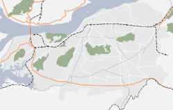
Kumarpara is a locality in Guwahati, Assam. [1] It is located to the west of the city and is a very densely populated and cosmopolitan area. The railway line passes at the North end of the locality and the Assam Trunk Road serves as the northernmost boundary. It is surrounded by the localities of Machkhowa, Bharalumukh, Fatasil Ambari and Athgaon. It comes under Bharalumukh Police Station. The Pin code of Kumarapara are 781 001 [2] (Served by Guwahati GPO) and 781 009 (Served by Bharalumukh Post Office). [3]

Contents

Geography

The locality falls in the floods plains of the Brahmaputra and is part of the city of Guwahati. The Northern boundary is marked by the Assam Trunk Road and the southern boundary is marked by the Bharalu river. The locality served by the Faiz Ahmed Road or F.A. road which serves as the main road and the KRC road. There a number of other arterial roads also. The drainage system mostly consists of modern drainage system which were rebuilt recently. [4] An old stream parallel to the F.A. road existed about 40 years ago but now been mostly filled up by land filling. Also, the locality is free from the problem of flash floods [5] which most of the other areas of the city suffer from. The Kumarpara panchali, is one of the rare intersections found in the city, where five streets meet. [6]

History

The locality is one of the oldest locality of the city of Guwahati and most families living here can trace their history to hundreds of years back. The rich history of the locality has been reflected in many books, such as Smritir Patat Mahanagarar Kumarpara by Md. Hedayat Ullah. [7]

Places of interest

Religious Institutions

The locality boosts of people of almost all major religious community found in India and thus, has many religious institutions present here. Some of them are very old and have a rich history. Some of the prominent ones are as follows, besides these there are numerous others also:-

Cultural Institutions

Educational Institutions

The locality boosts of number of schools and they cater to the people of the locality. Besides the schools, there are a number of tuition centers and coaching institutes spread all over the locality.

Sports Institutions

The clubs of the locality have very rich history and have participated in most of the tournaments organised in the city of Guwahati but due to rapid growth of infrastructure, the number of sports fields and ground in the locality has depleted.

Financial Institutions

Financial Facilities

See also

Related Research Articles

<span class="mw-page-title-main">Dispur</span> Locality in Guwahati city and Capital of Assam

Dispur is the capital of the Indian state of Assam and is a suburb of Guwahati.

<span class="mw-page-title-main">Morigaon</span> Town in Assam, India

Morigaon is a town of town area committee and the district headquarters of Morigaon district in the Indian state of Assam and including the headquarters of the Tiwa Autonomous Council (TAC), Tiwashong, Assam which was constituted by the Government of Assam on 14 April 1995, The Apex council will consist of 144 villages of Nagaon, Morigaon and Kamrup with 28 blocks. Pincode of Morigaon town is 782105.

Dergaon is a town and a municipality in the Golaghat district of Assam, India. It is 282 km from the state capital Guwahati.

Golokganj is a census town in Dhubri district in the Indian state of Assam. Golakganj is one of the historical places of Dhubri district.

Jagiroad is a town in the state of Assam. Jagiroad located in Mayong Sub-Division, in Morigaon district. It is situated on the south bank of Kolong river.

<span class="mw-page-title-main">Mangaldoi</span> Town in Assam, India

Mangaldoi; also spelt Mangaldai, Assamese pronunciation:[mɔŋɔldoɪ], is a town in the state of Assam, India. It's named after Mangaldahi, who was the daughter of the Raja of Darrang. She was married to Susenghphaa (r.1603-1641),, a ruler of the Ahom kingdom. Mangaldoi serves as the administrative headquarters of Darrang district. Positioned around 70 km to the east of Guwahati, the capital city of Assam.

<span class="mw-page-title-main">Pan Bazaar</span> Locality in Assam, India

Pan Bazaar is a locality in Guwahati, India surrounded by localities of Paltan Bazaar, Ambari and Fancy Bazaar. Situated on the banks of the river Brahmaputra, it is part of the city centre.

<span class="mw-page-title-main">Bhetapara</span> Locality in Assam, India

Bhetapara is a fast-growing mixed residential and commercial area of Guwahati city in Kamrup Metropolitan district in Assam state in India. It connects the Indira Gandhi Athletic Stadium to the rest of the city.

Bandlaguda Jagir is a satellite city of Hyderabad and a municipal corporation in Rangareddy district, Telangana, India. It Falls Under Gandipet mandal of Rajendranagar revenue division. It recently upgraded to a municipal corporation.

Chandmari is one of the oldest localities of Guwahati, Assam, India. Situated towards the eastern side of the city. It is home to All India Radio, Guwahati centre and a couple of academic institutions such as Holy Childs Convent, Bhaskar Bidyapith Higher Secondary School, Near Guwahati Commerce College Gauhati Commerce College, Assam Engineering Institute to name a few. Many high schools and degree colleges are set up in this area adding to its educational atmosphere. This part of city is also known for its recreational facilities. Bohag Bihu is regularly organized since 1961 at the A.E.I. playground which is also known as Chandmari Bihutoli by Pub Guwahati Bihu Sanmilan. Durga Puja is also regularly celebrated at Chandmari by the Chandmari Sarbajanin Durga Puja Committee. The neighboring residential areas around Chandmari are Milonpur, Nizarapar, Bamunimaidam, Kannachal, Pub-Sarania, Bhaskar Nagar etc. The area has one of the oldest movie theatres 'Anuradha' showing national and international movies.

<span class="mw-page-title-main">Narengi</span>

Narengi is a locality in Guwahati. Situated in the extreme east of the city, it has a sparse population. The southern part of the locality houses an army camp, while the Narangi railway station is located in the southern area near the Assam State Electricity Board colony. This station serves as a connection for trains traveling to the districts of Eastern Assam. Narengi falls under the jurisdiction of Noonmati Police Station. The Pin code of Narengi is 781026.

Maligaon is a locality of Guwahati, Assam. The headquarters of Northeast Frontier Railway and Northeast Frontier Railway Stadium is situated here.

Ambari is a locality in Guwahati, India.

Khanapara is a locality in Guwahati, Assam, India. Located in extreme south of Guwahati, it is hub for regional transportation. The Assam Public Service Commission, Assam Administrative Staff College, The College of Veterinary Science is located here with other offices of Veterinary department of Assam. Ganesh Mandir Indoor Stadium and Regional Science Centre are located here. This locality is also famous for its Teer Game which is played by people all over the Assam and Meghalaya. The old name of Khanapara was Kainapara. Kaina is a Khasi word, which means elephant, while Para in Khasi language means human settlements or colony.

Adabari is a locality in Guwahati.

Boko is a town located in Assam, in the Kamrup district in the Indian state of Assam. The town is composed of 139 villages. It is approximately 55 kilometers west of Guwahati.

Athgaon is a locality in Guwahati.

Dadara is a town in Kamrup district of Assam, situated on the north bank of the Brahmaputra River.

In May 1948, widespread rioting broke out in Guwahati and adjoining areas where Bengali Hindu businesses, schools and residences in general and Bengali Hindu staff of the Bengal and Assam Railway in particular were attacked. The Assamese Hindu nationalists who saw the Bengali Hindus as foreign usurpers in the territory of Assam led the attacks while Muslim League members joined them. The Bengali Hindus were looted and their properties were looted and set on fire. No Bengali-speaking Muslim was attacked, as they were seen as Na Asamiyas who had adopted Assamese language and culture and therefore assimilated in the land Assam. The Guwahati riots mark the beginning of the Bongal Kheda movement.

The Bharalu River is a tributary of the Brahmaputra River in the Indian state of Assam. The Bharalu river originates in the Khasi Hills of Meghalaya and flows through the heart of Guwahati before its confluence with the Brahmaputra river. Bharalu river is one of the most polluted rivers in the state of Assam.

References

[20]

  1. "Pincode of Kumarpara". pincode.org.in. Retrieved 20 May 2016.
  2. "Pincode for Guwahati GPO". pincode.org.in. Retrieved 20 May 2016.
  3. "Pincode of Kumarpara". pincode.org.in. Retrieved 20 May 2016.
  4. "News Drains for Guwahati". NDTV. NDTV. 8 July 2014. Retrieved 20 May 2016.
  5. "Flash Floods of Guwahati". The Indian Express. The Indian Express. 23 September 2015. Archived from the original on 21 November 2015. Retrieved 20 May 2016.
  6. "Kumarpara Panchali". pincodeofindia.in. Retrieved 20 May 2016.
  7. Md. Hedayat, Ullah (10 March 2015). Smritir Patat Mahanagarar Kumarpara (1 ed.). Chandmari, Guwahati: B.L. Impressions. p. 84.
  8. "History of Kumarpara Santi Sabha". The Assam Tribune. 11 October 2013. Retrieved 20 May 2016.
  9. "Sishu Niketan School". youtube. Retrieved 20 May 2016.
  10. "Oakland High School". getiit. Retrieved 20 May 2016.
  11. "Angels English High School". aapsasso.com. Retrieved 20 May 2016.
  12. "Details of Eurokids, Kumarpara". parentpuddle.com. Retrieved 20 May 2016.
  13. "Details of Bachpan Pre-School, Kumarapara". parentpuddle.com. Retrieved 20 May 2016.
  14. "Embrace United Club". The Telegraph. The Telegraph. 23 July 2007. Archived from the original on 10 October 2012. Retrieved 20 May 2016.
  15. "Nayantara Club". No. 30 December 2015. nelive.in. NE Live. Retrieved 20 May 2016.
  16. "Durga Puja of Nayantara Club". Hello Guwahati. Retrieved 20 May 2016.
  17. "Jai Hind Club celebrates Republic Day". Assam Times. Assam Times. 26 January 2008. Retrieved 20 May 2016.
  18. "Details of Central Bank of India, Kumarapara". bankifsccode.com. Retrieved 20 May 2016.
  19. "ATMs of Kumarpara". Googlemaps. Retrieved 20 May 2016.
  20. "Bharalu River in Guwahati remains Highly Polluted even after 10 years".