Sangli is a metropolitan town and the headquarters of Sangli District in Maharashtra, in south-western India. It has earned the nickname "Turmeric City of India" for being the hub of the Asia's largest production and trade of this spice. Sangli is situated on the banks of river Krishna and houses many sugar factories. A significant city in South-Western India, it lies 376 km from Mumbai, 230 km from Pune and 638 km from Bangalore. The city has a significant healthcare hub, including its twin City Miraj. Sangli-Miraj combined has more than 1000+ Hospitals and Clinics. Sangli is known as Turmeric city for its global turmeric trade as well grapes, raisins, jaggery and the most significant number of sugar factories in India, with district area having has more than 30 sugar factories. The Sangli region boasts the largest raisin market in Asia. Sangli-Miraj-Kupwad municipal corporation (SMKMC) along with its Urban Agglomeration consisting satellite towns of Madhavnagar & Budhgaon is 93rd biggest in India.

Raosaheb Ramrao Patil, better known as R. R. Patil, was an Indian politician from the state of Maharashtra. He was an MLA for Tasgaon vidhan sabha constituency from 1991 to 2015. He was an important leader of modern Maharashtra. He was a member of the Nationalist Congress Party. He became Home Minister of Maharashtra for the second time after the 2009 Maharashtra assembly election victory of the Congress-NCP alliance. He was also the former Deputy Chief Minister of Maharashtra.
Pune Division is one of the six administrative divisions of the Indian State of Maharashtra. Pune Division is bound by Konkan Division to the west, Nashik Division to the north, Aurangabad Division to the east, and the state of Karnataka to the south.

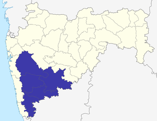
Sangli district is a district of Maharashtra state in India. Sangli city is the district headquarters. It is bordered by Satara district, Solapur district to the North, Karnataka state to the South-East, by Kolhapur district to South-West and by narrow portion on the East side to Ratnagiri district. It is present on the southern tip of Maharashtra.
Madhavnagar is a small city in sangli and now Suburb of Sangli Urban; Sangli district in the Indian state of Maharashtra.
Sangli-Miraj & Kupwad is urban agglomeration and a municipal corporation in Sangli district in the Indian state of Maharashtra.
Tasgaon is a city in Maharashtra and Taluka in Sangli district in the Indian state of Maharashtra. Tasgaon city is developing city in Maharashtra. Tasgaon was given as Jahagir to Parshuram Bhau Tasgaonkar by Narayanrao Ballal Peshwa in 1774. Tasgaon Sansthan was lapsed by British during ruling of Shrimant Ganpatrao Tasgaonkar.

The word Maharashtra, the land of the mainly Marathi-speaking people, appears to be derived from Maharashtri, an old form of Prakrit. Some believe that the word indicates that it was the land of the Mahars and the Rattas, while others consider it to be a corruption of the term 'Maha Kantara', a synonym for 'Dandakaranya'. Maharashtra is the third largest state in India after Rajasthan and Madhya Pradesh. It covers an area of 307,713 km2 and is bordered by the states of Madhya Pradesh to the north, Chhattisgarh to the east, Telangana to the southeast, Karnataka to the south and Goa to the southwest. The state of Gujarat lies to the northwest, with the Union territory of Dadra and Nagar Haveli sandwiched between the borders. Maharashtra has coastline of 720 km.The Arabian Sea makes up Maharashtra's west coast. Maharashtra consists of two major relief divisions. The plateau is a part of the Deccan tableland and the Konkan coastal strip abutting on the Arabian Sea.
Palus is a city and municipal council in sangli district.

The modern Indian Wine market is small but growing; annual per capita consumption of wine in the country is a mere 9 millilitres, approximately 1/8000th that of France. The main reason for this can be attributed to the fact that Indians preference for hard liquor and beer boasts nearly 98% of market share whereas wine with low ABV only has 2% market share. The viticulture in India has a long history, dating back to the time of the Indus Valley civilization when grapevines were believed to have been introduced from Persia. Winemaking has existed throughout most of India's history but was particularly encouraged during the time of the Portuguese and British colonization of the subcontinent. The end of the 19th century saw the phylloxera louse take its toll on the Indian wine industry, followed by religious and public opinion moving towards the prohibition. Following the country's independence from the British Empire, the Indian government encouraged vineyards to convert to table grape and raisin production. In the 1980s and 1990s, a revival in the Indian wine industry took place as international influences and the growing middle class started increasing demand for the beverage. By the turn of the 21st century, demand was increasing at a rate of 20-30% a year. The city of Nashik in the state of Maharashtra is called the "Wine Capital of India".
Savlaj is a village in Tasgaon tehsil in Sangli district in the Indian state of Maharashtra. It is named after the village god Lord Savalsiddh or Savalsiddha.
Manerajuri is a village in Maharashtra, India. It is, with a population of 14,204 according to the 2011 Census, largely an agricultural village in Tasgaon taluka situated on the Sangli-Atapadi road, 11.26 km to the east of Tasgaon. Madhavnagar and Bhilavadi are the nearest railway stations, both of which are about 22.53 km (14.00 mi) distant from it.
Bhilawadi is a town which located in palus taluka. it is near about only 16 km from Palus city. Bhilawadi, located on the bank of Krishna River. This town is one of the prominent producers of Grapes and Sugar Cane in Sangli district. Bhilawadi town has won the Nirmal Gram Purskar in Sant Gadage Baba Gram Swachhata Abhiyan.

Khanapur Vidhan Sabha seat is one of the 288 Vidhan Sabha constituencies of Maharashtra state in western India. It is a segment of Sangli Lok Sabha constituency. This seat was named 'Khanapur' until 1972. Then its name, and area under it, changed to 'Khanapur Atpadi', from 1978 to 2004. From 2008 onwards it was back to 'Khanapur' only, after the boundaries of constituencies were redrawn again.
Bamani (Vita) is a village in the Khanapur taluka of Sangli district in Maharashtra, India. Bamani is 14 km away from the prominent city Vita and 5 km from Vita-Tasgaon road. The village is surrounded by the villages Pare, Mangrul, Ghatimbi, Chinchni, Padli, Visapur, Limb, and Hatnur. Bamani comes under Khanapur-Atpadi state constituency and Sangli parliamentary constituency. Vita-Kavthe Mhankal state road goes through Bamani. It is the last village in Khanapur Taluka mainly concentrated on an agricultural economy. Bamani has many animal husbandry farms with buffaloes, cattle, goats, and poultry.
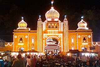
The Lord Ganapati Temple is situated in the city of Tasgaon in Sangli district in the Indian state of Maharashtra. Most of the Ganapati idols have a left-sided trunk, while this temple's idols' trunk bends towards the right. The Ganapati idol with the trunk curved towards the right is said to be 'active (jagrut)’. This Ganapati is regarded as a living idol, ready to bless communities with good luck, wisdom, prosperity and happiness. The idol is embellished with solid gold, weighing 125 kilograms (276 lb).
Sanjay Ramchandra Patil is a politician from Tasgaon of Sangli district of Maharashtra state in India.
Kundal is a town in Palus Taluka within the Sangli District of southwestern Maharashtra, India. It has a population of 18,287 people - 9,432 males and 8,855 females according to the 2011 census. Kundal is located 40 kilometres north of the district capital, Sangli and 5km from Palus.
Upalavi is a village in the Tehsil tasgaon of Sangli district, Maharashtra, India, about 18 kilometres north of Sangli. It is situated along the Sangli-Tasgaon state highway.
Sangli raisins is a variety of raisin produced in the Indian state of Maharashtra in the Sangli district. Sangli District is located in the western part of Maharashtra, situated in the Managanga River-bed. The district is surrounded by the Warana and Krishna rivers. The Krishna River flows through the district for 105 km. The region's monsoon rains, fertile soil, and cool climate make it suitable for growing grapes. The major raisin-producing areas are Tasgaon, Miraj, Palus, and Kadegaon. Sangli district holds the top position as the largest raisin-producing district in India with 70% of total production.

