
Dindigul district is an administrative region in the southwest of Tamil Nadu, India. The district was carved out of Madurai District in 1985. It has an area of 6266.64 km2 and comprises three Revenue Divisions, nine Taluks, and 14 Panchayat Unions. The district is bound by Tirupur, Karur, and Trichy districts in the north, the Sivaganga and Tiruchi districts in the east, the Madurai district in the south, and the Theni district and the state of Kerala in the west. As of 2011, the district had a population of 2,159,775 with a sex-ratio of 998 females for every 1,000 males.

In India, the Panchayati Raj generally refers to the system of local self-government in India introduced by a constitutional amendment in 1992, although it is based upon the traditional panchayat system of the Indian subcontinent. The recommendation of L.M Singhvi Committee(1986) was accepted. This Panchayati Raj system was formalized in 1992, following a study conducted by a number of Indian committees on various ways of implementing more decentralized administration. The modern Panchayati Raj and its Gram Panchayats are not to be confused with the extra-constitutional Khap Panchayats found in northern India.

Batlagundu is a town in Dindigul district in the Madurai Region state of Tamil Nadu, India. The name Vettrilaikkundru later transformed and changed to Vatthalagundu. The town is the major gateway to Kodaikanal. Subramaniya Siva was a writer and activist born in Batlagundu. Batlagundu is the fifth-largest town in the Dindigul district. Batlagundu has most of the voters in Nilakottai Constituency.
Oddanchatram is a town in Dindigul district in the Indian state of Tamil Nadu. It is the second largest town in Dindigul district. Oddanchatram is also famous for vegetable and cattle market. It is located at the base of the western ghats in South India. As of 2011, the town had a population of 50,064. It is known as the vegetable city of Tamil Nadu. Oddanchatram vegetable market is the largest supplying market in Tamilnadu and Kerala. Agriculture is the major economic support for the town.

Manjampatti Valley is a 110.9 km2 (42.8 sq mi) protected area in the eastern end of Indira Gandhi Wildlife Sanctuary and National Park (IGWS&NP) in Tirupur District, Tamil Nadu, South India. It is a pristine drainage basin of shola and montane rain forest with high biodiversity recently threatened by illegal land clearing and cultivation.

Vilpatti is a Panchayat in Kodaikanal Taluk of Dindigul district, Tamil Nadu state, South India. It is composed of the main village of Vilpatti and 11 hamlets. Vilpatti village is 9 km NW of Kodaikanal town, 2 km past Perumal Malai village on the Palani Road. It is an agricultural area with the primary crops of potatoes, carrot, coffee and bananas.
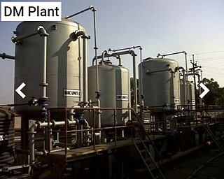
The water supply and sanitation in India has increased greatly from 1980 to present. Still, many people lack access to clean water, toilets, and sewage infrastructure. Various government programs at national, state, and community level have brought rapid improvements in sanitation and the drinking water supply. These various programs are ongoing.
Poombarai is a village located in the heart of the Palani hills of Tamil Nadu, India, 18 kilometers (11 mi) from Kodaikanal. It is situated at 1,920 meters (6,300 ft) above the sea level.
Mannavanur, is a farming village of 1437 households in Mannavanor Panchayat, Dindigul district, Tamil Nadu, India, 35 kilometres (22 mi) west from Kodaikanal It is 7 kilometres (4 mi) by road from Kumbur village and 9 kilometres (6 mi) from Kilanavayal village. Altitude is 1,880 metres (6,170 ft).
Southern Regional Research Centre (SRRC) is a regional centre of the Central Sheep & Wool Research Institute (CSWRI), a premier Institution of the Indian Council of Agricultural Research (I.C.A.R), New Delhi. The SRRC was founded on November 16, 1965 and has been active for over 45 years at Mannavanur. The centre was created in 1965 by former Agriculture Minister, Shri C. Subramaniam. It is located 30 km away from Kodaikanal. This centre is the animal science research centre under ICAR for both Tamil Nadu and Kerala states. It is located in Mannavanur village, Dindigul district in the Indian state of Tamil Naduon 1,340 acres (5.4 km2) of rolling grassland at altitude 2,000 metres (6,600 ft).
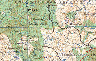
Kilanavayal (Keelanavayal) is a small village of terrace farmers in Mannavanur panchayat at the far eastern end of the Manjampatti Valley drainage basin in the Palani Hills. There is a 9 kilometers (5.6 mi) road between Mannavanur and Kilanavayal. There is a trekking route from Mannavanur via Keelanavayal to ManjampattI and Thalinji. It is in Kodaikanal block of Dindigul district, Tamil Nadu state, India. Altitude is 1,755 meters (5,758 ft) at: 10°15′53″N77°19′40″E.
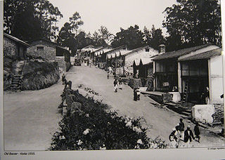
Kodaikanal is a city and a Taluk division of Dindigul district in the state of Tamil Nadu, India.
Kookal is a Panchayat village of terrace farmers at the far western end of the Palani Hills in Kodaikanal block of Dindigul district, Tamil Nadu state, South India. It is 40 kilometres (25 mi) from Kodaikanal at: 10°17′9″N77°21′48″E. Elevation is 1,890 metres (6,200 ft). Kookal is notable for the high biodiversity of the area.
Kavunji is a Panchayat village of terrace farmers at the far western end of the Western Ghats in Kodaikanal block of Dindigul district, Tamil Nadu state, South India, Pincode 624103. It is 35 kilometres (22 mi) from Kodaikanal at: 10°12′26″N77°20′25″E. Elevation is 1,920 metres (6,300 ft). Kavunji is notable as a vegetable farming area.

The Kodaikanal–Munnar Road was located in Dindigul District and Theni District of Tamil Nadu and Idukki district of Kerala in South India. It covers 81 kilometers (50 mi) from Kodaikanal to Munnar. The road was improved by the British in 1942 as an evacuation route in preparation for a possible Japanese invasion of South India. With a maximum elevation of 2,480 meters (8,140 ft) just south of Vandaravu Peak, it was among the highest roads in India, south of the Himalayas, prior to its closure in 1990.
Brammadesam is an Indian Panchayat village located in Tindivanam taluk of Villupuram district in the state of Tamil Nadu. It is one of the 56 village panchayats coming under Marakkanam block of the Villupuram district. The village code for Brahmadesam is 10 and it falls under the Marakkanam Block.
Kodaikanal block is a revenue block in the Dindigul district of Tamil Nadu, India. It has a total of 15 panchayat villages.
Nilakottai block is a revenue block in the Dindigul district of Tamil Nadu, India. It has a total of 23 panchayat villages.
10.45°N 77.52°EPalani block is a revenue block in the Dindigul district of Tamil Nadu, India. It has a total of 20 panchayat villages.


