Related Research Articles
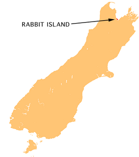
Moturoa / Rabbit Island is a small island that lies across the southernmost part of Tasman Bay / Te Tai-o-Aorere, on the northern coast of New Zealand's South Island. The long narrow island runs east–west for 8 kilometres (5 mi), and covers 15 km2 (5.8 sq mi).

Ward is a small town in Marlborough, New Zealand. It is located on State Highway 1, 82 kilometres (51 mi) north of Kaikoura. The Flaxbourne River flows past to the north and into the Pacific Ocean at Ward Beach to the south-east of Ward. A current initiative aims to have the town renamed as Flaxbourne.

The Aldermen Islands are a small group of rocky islets to the southeast of Mercury Bay in the North Island of New Zealand. They are located off the coast of the Coromandel Peninsula, 20 kilometres (12 mi) east of the mouth of the Tairua River.

The Waiuku River is southwest of the city of Auckland in New Zealand. Despite its name, the "river" is in fact an estuarial arm of the Manukau Harbour. It joins the harbour at the south west and extends south for 12 kilometres (7 mi), having its head close to the town of Waiuku.
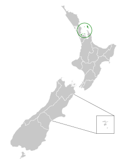
The Hibiscus Coast is a populated area on a stretch of the Hauraki Gulf coast in New Zealand's Auckland Region. It has a population of 60,400, making it the 11th most populous urban area in New Zealand, and the second most populous in the Auckland Region, behind Auckland itself.

Manaia is a rural town in South Taranaki District, New Zealand. Ōpunake is 29 km to the northwest, and Hāwera is 13 km to the southeast. Kaponga is 15 km north. State Highway 45 passes through the town. Manaia is named after the former Māori chief of the district, Hukunui Manaia.

For the current top-level subdivision of Taranaki in New Zealand, see Taranaki region

The Kumeu River drains the northern Waitākere Ranges near Auckland, New Zealand, running past the town of Kumeū before merging into the Kaipara River.
The Okura River, also known as the Okura Estuary, is a river in the north of the Auckland Region in the North Island of New Zealand. The river rises in the low hills to the south of Silverdale and flows into Karepiro Bay on the Hauraki Gulf. The river is extremely tidal with only a narrow channel being navigable by small craft at low tide. The area is popular for horse riding, riders wait till low tide and then ford the boating channel to ride the estuary and beaches on the northern side.
The Arapaoa River is a northeastern arm of the Kaipara Harbour in Northland, New Zealand. Officially designated as a river, it is some 17 kilometres (11 mi) long and an average of 3 kilometres (2 mi) wide.
The Makarau River is a river of the Auckland Region of New Zealand's North Island. The river rises some 10 kilometres (6 mi) north of Kaukapakapa, flowing west before entering the south of the Kaipara Harbour.
The Mangawai River is a river of the Northland Region of New Zealand. It flows east into the Wairoa River close to its outflow into the Kaipara Harbour.

The Orewa River is a river of the Auckland Region of New Zealand's North Island. It flows east to reach Whangaparaoa Bay just to the north of Whangaparaoa Peninsula. The town of Orewa is near the river's mouth.

The Oruawharo River is a river on the North Auckland Peninsula of New Zealand. It flows westward into the Kaipara Harbour west of Wellsford. It forms part of the boundary between the Northland region and the Auckland Region.
The Tauhoa River is an estuarial arm of the Kaipara Harbour in the Auckland Region of New Zealand's North Island. As part of the harbour's drowned valley system, it consists of narrow channels flowing south through expanses of mudflat to meet with the main waters of the Kaipara due east of the harbour entrance. The Tauhoa Channel links the entrance with the river mouth.

The Whau Local Board is one of the 21 local boards of the Auckland Council. It is the only local board overseen by the council's Whau Ward councillor.
McGregor Glacier is a tributary glacier, 14 nautical miles (26 km) long and 3 nautical miles (6 km) wide, draining the southwest slopes of the Prince Olav Mountains in Antarctica, and flowing west to enter Shackleton Glacier just north of the Cumulus Hills. It was named by the Southern Party of the New Zealand Geological Survey Antarctic Expedition (1961–62) for V.R. McGregor, a geologist with that party.
Auckland District Health Board (ADHB) was a district health board that provided healthcare in the Auckland Region in New Zealand, mainly on the Auckland isthmus. This district health board existed between 2001 and 2022 and was governed by a part-elected, part-appointed board.

The Waitemata District Health Board was a district health board with the focus on providing healthcare to people living in the area that used to be covered by North Shore city, Rodney District, and Waitakere City in New Zealand. It was abolished on July 1st 2022 and replaced with Health New Zealand.

The Swanson Stream is a stream of the Auckland Region of New Zealand's North Island. It flows north-east from its source the Waitākere Ranges through rural West Auckland towards the suburb of Swanson, before joining the Momutu Stream, which exits into Te Wai-o-Pareira / Henderson Creek and the western the Waitematā Harbour. Since the mid-2000s has been forested with native flora.
References
"Place name detail: Kumengamatea River". New Zealand Gazetteer. New Zealand Geographic Board . Retrieved 12 July 2009.
Coordinates: 36°08′S174°06′E / 36.133°S 174.100°E