Kumplampoika

Last updated

Kumplampoika

Kumbalampoika
village
Kpoika Jn.JPG
Kumpalam poika
Coordinates: 9°19′0″N76°48′0″E / 9.31667°N 76.80000°E / 9.31667; 76.80000 Coordinates: 9°19′0″N76°48′0″E / 9.31667°N 76.80000°E / 9.31667; 76.80000
CountryFlag of India.svg  India
State Kerala
District Pathanamthitta
Government
  Type Panchayath
Area
  Total10 km2 (4 sq mi)
Population
 (2008)
  Total10,000
  Density1,000/km2 (2,600/sq mi)
Languages
  Official Malayalam, English
Time zone UTC+5:30 (IST)
PIN
689661
Telephone code04735
Vehicle registration KL-03
Nearest cityPathanamthitta
Sex ratio 1000m:1000f /
Literacy99%
Lok Sabha constituencyPathanamthitta
Climate Moderate (Köppen)

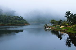
Kumplampoika is a village in Pathanamthitta district of Kerala, India.

Pathanamthitta district District in Kerala, India

Pathanamthitta District is a district in the southern part of Kerala, India. The district headquarters is in the town of Pathanamthitta. There are four municipalities in Pathanamthitta: Tiruvalla, Adoor, Pathanamthitta and Pandalam.

Kerala State in southern India

Kerala is a state on the southwestern Malabar Coast of India. It was formed on 1 November 1956, following passage of the States Reorganisation Act, by combining Malayalam-speaking regions. Spread over 38,863 km2 (15,005 sq mi), Kerala is the twenty-second largest Indian state by area. It is bordered by Karnataka to the north and northeast, Tamil Nadu to the east and south, and the Lakshadweep Sea to the west. With 33,387,677 inhabitants as per the 2011 Census, Kerala is the thirteenth-largest Indian state by population. It is divided into 14 districts with the capital being Thiruvananthapuram. Malayalam is the most widely spoken language and is also the official language of the state.

India Country in South Asia

India is a country in South Asia. It is the seventh-largest country by area, the second-most populous country, and the most populous democracy in the world. Bounded by the Indian Ocean on the south, the Arabian Sea on the southwest, and the Bay of Bengal on the southeast, it shares land borders with Pakistan to the west; China, Nepal, and Bhutan to the north; and Bangladesh and Myanmar to the east. In the Indian Ocean, India is in the vicinity of Sri Lanka and the Maldives; its Andaman and Nicobar Islands share a maritime border with Thailand and Indonesia.

Contents

Kumpalampoika Town Federal bank.JPG
Kumpalampoika Town
Kumplampoika Highschool Kumplampoika CMSHS.JPG
Kumplampoika Highschool

History

Kumplampoika evolved out of "Kumbhi Ulavum Poika" which literally connotes the presence of "Kumbhi" (elephant) in the village until a few hundred years back.

Landmarks

There are three churches, temples, branches of major banks, library (Bodleian library, RegNo. 03 RNI 1797 affiliated by State Library council), co-operative societies, a retail market, and a vegetable market.

Transportation

Kumplampoika is 8  km equidistant from Pathanamthitta and Ranni.

Economy

The main contribution to the economy is in the form of remittance from NRIs and rubber plantations and other low scale farm cultivation.

Non-resident Indian and person of Indian origin Overseas Indians

Overseas Indians, officially known as Non-resident Indians (NRIs) or Persons of Indian Origin (PIOs), are people of Indian birth, descent, or origin who live outside the Republic of India. Overseas Indians are various individuals or ethnic groups associated with India, usually through ancestry, ethnicity, nationality, citizenship or other affiliation and live abroad overseas. According to a Ministry of External Affairs report, there were 30,995,729 NRIs and PIOs residing outside India as of December 2018. India has one of the largest diaspora populations in the world with over 15.6 million according to the United Nations Department of Economic and Social Affairs.

Related Research Articles

Kozhencherry town in Kerala, India

Kozhencherry is a census town in Pathanamthitta district of Central Travancore region in Kerala state, South India. As of 2011 census, the population was 12,021 people in 3,393 households.It is one of the main city in the Pathanamthitta, District. It is on the banks of Pampa river. It is a commercial centre and many banks and trade companies have their establishments here. It is believed that once the Kovilans of Thekencore kingdom's ruled this area. Kozhencherry used to be a part of the erstwhile Travancore kingdom.

Ranni Town/Taluk in Kerala, India

Ranni sometimes spelled Ranny, is a small town in the Pathanamthitta district of Kerala, in India. The taluk headquarters is a small township on both sides of the Pamba River. Ranni is also one of the largest taluks in Kerala. The renowned Hindu temple of Sabarimala is in this taluk, situated approximately 66 km from the main town, Ittiappara. Ranni is known for its natural environment, forests, hills, river and good climate.

Vadasserikara Town in Kerala, India

Vadaserikara is a village in Pathanamthitta district, in the state of Kerala, India. It is one of the 11 villages in Ranni and sits at the confluence of the Pamba and Kallar Rivers.

Mallappuzhassery village in Kerala, India

Mallappuzhassery is a village situated in the Greater Kozhencherry region near the Aranmula Parthasarathy Temple, in the Pathanamthitta district in Kerala, India. Its border starts in the middle of the temple grounds running north–south: the eastern part is Mallappuzhassery and the western part is Edasserimala. Edasserimala is part of Aranmula Panchayath and Mallappuzhassery is of Mallappuzhassery Panchayath. The northern border of this village is the Pamba River.

Kidangannoor village in Kerala, India

Up

Pullad Place in Kerala, India

Pullad is a small town in Pathanamthitta district. Pullad is a part of Tiruvalla Taluk (തിരുവല്ല) and in the Koipuram village, "Special Grade below Municipality level" 12 km east from Tiruvalla SCS Junction, Take 20 minutes to drive from Thiruvalla Kerala state, India. Pullad is the part of Aranmula legislative assembly constituency.

Main Eastern Highway road in Kerala, India

The Main Eastern Highway is the lifeline of the high range townships of the Travancore region of Kerala state, India. It is also known as Punalur-Pathanamthitta-Palai-Thodupuzha-Muvattupuzha Highway. Main Eastern Highway is categorized as State Highway - 08 of Kerala. It is the second longest State Highway of Kerala covering a distance of 153.6 km. The districts it passes through are Kollam, Pathanamthitta, Kottayam, Idukki and Ernakulam.

Vallicode village in Kerala, India

Vallicode is a village in Pathanamthitta district in Kerala, India. It is situated at about 7 km from the district headquarters of Pathanamthitta at south-east direction.

Koodal town in Kerala, India

Koodal is the second largest town in Konni Taluk at Pathanamthitta District, located in Kerala state, India.Koodal Situates On Main Eastern Highway.

Perunad (Ranni-Perunad) is a scenic hilly village in Pathanamthitta district, Kerala state, India It's located on the banks of Pamba River and Kakkadu River.

Elanthoor village in Kerala, India

Elanthoor is a village in Pathanamthitta district in the state of Kerala, India.

Ezhumattoor village in Kerala, India

Ezhumattoor is a village in Pathanamthitta district in the state of Kerala, India,since the formation of Pathanamthitta district in 1982. Ezhumattoor has 27.89 km2 area,it is divided into 14 wards for administrative purpose,it was formed by a government Order on 16 January 1952.

Kavumbhagom Municipal town in Kerala, India

Kavumbhagom or Kavumbhagam is a place in Thiruvalla town, Pathanamthitta district, Kerala, India. Kavumbhagom is an important junction and part of the Thiruvalla Municipality. It is also a census village.

State Highway 7 (Kerala) road in Kerala, India

The SH-07 / T.K.Road is the life line of the Central Travancore.

Panchganga River river in India

The Panchganga River is one of the important rivers of India located in Maharashtra. In English, the name translates as "Five Rivers". It is a major tributary of Krishna River, with which it joins at Narsobawadi..

Gavi, Kerala Village in Kerala, India

Gavi is a village in Pathanamthitta district, Kerala, India. It is located 28 km southwest of Vandiperiyar, a town in Idukki on N.H 220, the highway connecting Kollam and Madurai.

Pilu oil

Pilu oil is an extract from seeds of the pilu tree, the meswak tree, and the mustard tree.

References