Khammam is the city in Khammam district of the Indian state of Telangana. It is the fourth largest city in the state. It is the headquarters of the Khammam district and Khammam mandal also. It is located about 193 kilometres (120 mi) east of the state capital, Hyderabad, 61 kilometres (38 mi) from Suryapet, 120 kilometres (75 mi) from Warangal and also it is located about 121 kilometres (75 mi) North of the Andhra Pradesh state capital, Amaravathi. The river Munneru flows on the western side of the city. As of 2011 census of India, Khammam urban agglomeration has a population of 313,504. However, on 19 October 2012, the civic body of Khammam was upgraded to a municipal corporation. Post- upgradation to corporation, the population of Khammam was approximated to be 3,07,000. During 2014-2023 under BRS regime Khammam got a major changeover, roads expansion, Medical College, Engineering College, ITHub.

Khammam district is a district in the eastern region of the Indian state of Telangana. The city of Khammam is the district headquarters. The district shares boundaries with Suryapet, Mahabubabad, Bhadradri districts and with Eluru and NTR districts.

Hanamkonda district, is a district in the Indian state of Telangana. The district headquarters are located at Hanamakonda. The district borders the districts of Jangaon, Karimnagar, Warangal, Bhupalpally and Siddipet.
Pedana is a municipality and the headquarters of Pedana mandal under Machilipatnam revenue division of Krishna district of the Indian state of Andhra Pradesh. It is located at a distance of 8 km (5.0 mi) from the district headquarters, Machilipatnam.
Venkatagiri is a town in Tirupati district of the Indian state of Andhra Pradesh. It is a municipality and mandals headquarters of Venkatagiri mandal. Venkatagiri's old name is "Kali Mili". It is famous for its Handloom Cotton Sarees. Venkatagiri is a place for history and handlooms. It was part of a small kingdom that was integrated into the Indian Republic.
Sathupalli is a town in Khammam district of the Indian state of Telangana. It is a Municipality in Sathupalli mandal of Kalluru revenue division. It is situated approximately 276 km (171 mi) east of Hyderabad, 80 km (50 mi) from Khammam and 200 km (120 mi) from Warangal. It is about 135 km (84 mi) north of Amaravati, the state capital of Andhra Pradesh, and 126 km (78 mi) west of Rajahmundry.

Penuganchiprolu is a village situated in the NTR district of Andhra Pradesh, India. Serving as the mandal headquarters for Penuganchiprolu mandal, it falls under the administration of the Nandigama revenue division. It is situated 71 kilometers northwest of the district headquarters, Vijayawada, and 50 kilometers south of the nearest city, Khammam.
Gokavaram is a village in Gokavaram mandal, East Godavari district in the state of Andhra Pradesh in India.

Velairpadu mandal also spelled as Velerupadu is located in the Eluru district of the Indian state of Andhra Pradesh. Previously, Velairpadu was part of the Khammam district in the then united Andhra Pradesh. However, it became part of Andhra Pradesh following the transfer of seven mandals, including Velairpadu, from Telangana to the newly formed Andhra Pradesh after bifurcation.

Khammam Assembly constituency is a constituency of the Telangana Legislative Assembly. It is one of the 5 constituencies in Khammam district. It includes the city of Khammam and is part of Khammam Lok Sabha constituency.
Aswaraopeta is a ST reserved constituency of Telangana Legislative Assembly, India. It is one of 10 constituencies in Khammam district. It is part of Khammam Lok Sabha constituency.
Doli Gutta is a peak in the northern part of the Deccan Plateau. It is located at the border of Mulugu district in Telangana and Bijapur district in Chhattisgarh, India.
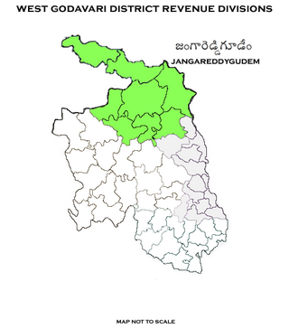
Jangareddygudem revenue division is an administrative division in the Eluru district of the Indian state of Andhra Pradesh. It is one of the 3 revenue divisions in the district which consists of 10 mandals under its administration. Jangareddygudem is the divisional headquarters.

Warangal district, formerly Warangal Rural district, is a district in the Indian state of Telangana. The district shares boundaries with Mahabubabad, Jangaon, Hanamkonda, Mulugu and Bhupalpally districts.
Yerrakaluvaa is a river that forms boundary between Khammam district of Telangana and West Godavari district of Andhra Pradesh.
Razole mandal is one of the 22 mandals in Dr. B.R. Ambedkar Konaseema district of Andhra Pradesh. As per census 2011, there are 13 villages in this mandal.
Uppalaguptam mandal is one of the 22 mandals in Dr. B.R. Ambedkar Konaseema district of Andhra Pradesh. As per census 2011, there are 14 villages in this mandal.
Kunavaram is a village in Uppalaguptam Mandal, Dr. B.R. Ambedkar Konaseema district in the state of Andhra Pradesh in India.


