
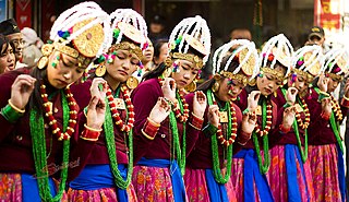
Upper Mustang is an upper part of Mustang District, which is located in Nepal. The Upper Mustang was a restricted kingdom until 1992 which makes it one of the most preserved regions in the world, with a majority of the population still speaking traditional Tibetic languages. Tibetan culture has been preserved by the relative isolation of the region from the outside world. Life in Mustang revolves around tourism, animal husbandry, and trade.
Gurung or Tamu are an ethnic group indigenous to the hills and mountains of Gandaki Province of Nepal. Gurung people predominantly live around the Annapurna region in Manang, Mustang, Dolpo, Kaski, Lamjung, Gorkha, Parbat and Syangja districts of Nepal and parts of India. They are one of the main Gurkha tribes.

The Thakali are an ethnolinguistic group originating from the Thak Khola region of Mustang District in the Gandaki Province of Nepal. Thak-sat-se is the traditional area of the Thakali community, which lies over Mustang District, the valley of the Kali Gandaki river in western Nepal. According to the 2001 census, Thakali population of around 12,973 constituted only 0.06% of Nepal's population. As per the 2011 Nepal census, there are 13,215 Thakali people in Nepal.

Dhading District, a part of Bagmati Province, is one of the seventy-seven districts of Nepal. The district, with Dhading Besi as its district headquarters, covers an area of 1,926 square kilometres (744 sq mi), had a population of 338,658 in 2001 and 336,067 in 2011.

Dolpa District, is a district, located in Karnali Province of Nepal, It is one of the seventy-seven districts of Nepal and one of ten district of Karnali. The district, with Dunai as its district headquarters, covers an area of 7,889 km2 (3,046 sq mi) and has a population (2011) of 36,700. Dolpa is the largest district of Nepal.
Jumla District, is one of the ten districts of the Karnali province of Nepal. This district has Jumla as its headquarters, an area of 2,531 square kilometres (977 sq mi); it had populations of 89,427 and 108,921, respectively, in the national censuses of 2001 and 2011. Its territory lies between longitudes 81⁰ 28' and 82⁰ 18' East, and between latitudes 28⁰ 58' and 29⁰ 30' North.

Manang District (Nepali: मनाङ जिल्लाListen , a part of Gandaki Province, is one of the seventy-seven districts of Nepal. The district, with Chame as its district headquarters, covers an area of 2,246 km2 and had a population of 6,538.

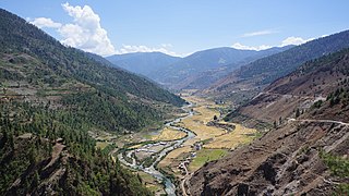
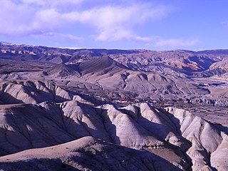
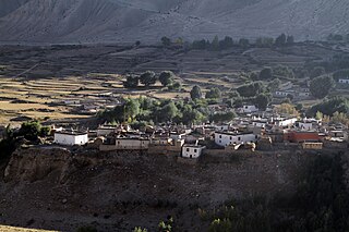
Mustang District is one of the eleven districts of Gandaki Province and one of seventy-seven districts of Nepal which was a Kingdom of Lo-Manthang that joined the Federation of Nepal in 2008 after abolition of the Shah dynasty. It covers an area of 3,573 km2 (1,380 sq mi) and has a population (2011) of 13,452. The headquarters is located at Jomsom. Mustang is the 5th largest district of Nepal.
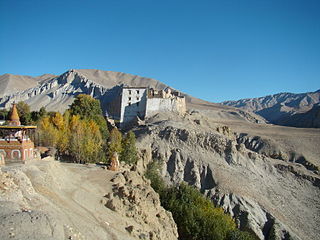
Lomanthang is a rural municipality in Mustang district in Gandaki Province of western Nepal. It is located at the northern end of the district, bordering the Tibet Autonomous Region of China to the north and Dalome rural municipality of Mustang in the south.
Languages of Nepal constitutionally called Nepalese languages are the languages having at least an ancient history or origin inside the sovereign territory of Nepal spoken by Nepalis. The 2011 national census lists 123 languages spoken as a mother tongue in Nepal. Most belong to the Indo-Aryan and Sino-Tibetan language families.

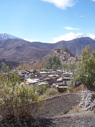
Kagbeni is a village in the Baragubg Muktikshetra rural municipality of Mustang District of the Himalayas, in Nepal, located in the valley of the Kali Gandaki River. At the time of the 2011 Nepal census it had a population of 555 people. It lies on the trail from Jomsom to the royal capital Lo Manthang, near the junction with the trail to Muktinath. Kagbeni is also regarded as one of the oldest villages in the Himalayas.
Charang (Tsarang) is a village development committee in Mustang District in the Dhawalagiri Zone of northern Nepal. At the time of the 1991 Nepal census it had a population of 682 people living in 130 individual households.
Chhonhup is a village development committee in Mustang District in the Dhawalagiri Zone of northern Nepal. At the time of the 1991 Nepal census it had a population of 1047 people living in 192 individual households.
Dhami, Nepal is a village development committee in Mustang District in the Dhawalagiri Zone of northern Nepal. At the time of the 1991 Nepal census it had a population of 850 people living in 158 individual households.
Jhong is a village development committee in Mustang District in the Dhawalagiri Zone of northern Nepal. At the time of the 1991 Nepal census, it had a population of 450 people living in 91 individual households.
Surkhang is a village development committee in Mustang District in the Dhawalagiri Zone of northern Nepal. At the time of the 1991 Nepal census it had a population of 651 people living in 130 individual households.

Tukuche, sometimes spelt Tukche, is a village development committee in Mustang District in the Dhawalagiri Zone of northern Nepal. At the time of the 1991 Nepal census it had a population of 652 people living in 166 individual households.

Ngawal (Nawal) is a village development committee in Manang District in the Gandaki Zone of northern Nepal. At the time of the 2011 Nepal census it had a population of 274. Ngawal VDC is one of the Seven Village Development Committee in Upper Manang. One of the main attraction of this village is a centuries-old cave of Guru Rinpoche that is on the hills overlooking Ngawal village. The local people believes the cave leads to Mustang. And a monastery in Tibetan Nyingma pa sect which is called Portoche Monastery. 16

Gandaki ProvinceListen (help·info)), is one of the seven federal provinces established by the current constitution of Nepal which was promulgated on 20 September 2015. Pokhara is the province's capital city. It borders the Tibet Autonomous Region of China to the north, Bagmati Province to the east, Karnali Province to the west, and Lumbini Province and Bihar of India to the south. The total area of the province is 21,504 km2 - about 14.57% of the country's total area. According to the latest census, the population of the province was 2,479,745. The newly elected Provincial Assembly adopted Gandaki Province as the permanent name by replacing its initial name Province no. 4 in July 2018. Krishna Chandra Nepali is the present chief minister of Gandaki Province.
Lo-Ghekar Damodarkunda (earlier:Dalome) is a rural municipality situated in Mustang District of Gandaki Province of Nepal. The rural municipality is situated on the northern part of the Mustang, surrounded by Lomanthang rural municipality on the north, Barhagaun Muktichhetra on the south, Manang District on the south-east and Dolpa District on the west, north-eastern border of the rural municipality touches border with Tibet of China.


