Ancash is a region of northern Peru. It is bordered by La Libertad Region on the north, Huánuco and Pasco regions on the east, the Lima Region on the south, and the Pacific Ocean on the west. Its capital is the city of Huaraz, and its largest city and port is Chimbote. The name of the region originates from the Quechua word anqash, from anqas (blue) or from anka (eagle).

Lake Querococha is a lake in Peru located in the Ancash Region, Recuay Province, in the districts Ticapampa and Catac. The lake is situated at a height of 3,980 metres (13,058 ft), about 2.43 km long and 0.87 km at its widest point. Lake Querococha lies on the western side of the Cordillera Blanca, southwest of Yanamarey and Pucaraju, northwest of Mururaju and Queshque and east of Recuay.

Tuco,Tuku,Tucu or Huanaco Punta is a mountain in the Andes in South America. Its summit is 5,479 m (17,976 ft)) high and it is one of the southernmost peaks in the snow-capped Cordillera Blanca in northwestern central Peru. Tuco is located in the Ancash Region, Bolognesi Province, Aquia District and in the Recuay Province, Catac District. It is situated northeast of Caullaraju, between Challhua in the west and Pastoruri in the east.

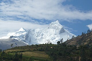
Caullaraju or Jeulla Rajo is a mountain in the Cordillera Blanca in the Andes of Peru, about 5,682 m (18,642 ft) high. It is located in the Ancash Region, Recuay Province. In the IGN-Peru map, the highest peak is reported to be named Jenhuaracra.

Shacsha,Shaqsha,, Huantsán Chico or Huanchan is a mountain in the Cordillera Blanca in the Andes of Peru, about 5,703 metres (18,711 ft) high,. It is situated in the Ancash Region, Huaraz Province, Olleros District. Shacsha lies southwest of Huantsán, west of Uruashraju and southeast of the town of Huaraz.

Huamashraju,Wamashraju,, Yanahuacra or Rajo Colta is a mountain in the Cordillera Blanca in the Andes of Peru, about 5,434 metres (17,828 ft) high. It is situated in the Ancash Region, Huaraz Province, Huaraz District. Huamashraju lies east of the town of Huaraz, west of Huantsán and northwest of Shacsha and Cashan.
Pucaraju is a mountain in the Cordillera Blanca in the Andes of Peru, about 5,346 metres (17,539 ft) high or 5,322 metres (17,461 ft) high depending on the source. It is situated in the Ancash Region, Recuay Province, Ticapampa District. Pucaraju lies west of Yanamarey and northeast of Lake Querococha.
Challhua, Wiksu or Huicsu is a mountain in the southern Cordillera Blanca in the Andes of Peru, about 5,487 m (18,002 ft) high. Challhua is located in the Ancash Region, Bolognesi Province, Aquia District and in the Recuay Province, Catac District. It is situated northeast of Caullaraju, west of Pastu Ruri and Tuco and south of Santun. One of the nearest places is the village of Wicso, located next to Callan creek, west of the mountain. This creek flows to the Pumapampa River, a right affluent of the Santa River.
Uruashraju or Verdecocha is a mountain in the Cordillera Blanca of the Andes of Peru, about 5,722 metres (18,773 ft) high. It is located in the Ancash Region, Huaraz Province, Olleros District, and in the Huari Province, Chavín de Huantar District. Uruashraju lies south of Huantsán, east of Cashán and Shacsha, and southeast of Lake Tararhua.
Lake Allpacocha, Lake Japracocha or Lake Japrucocha is a lake in the Cordillera Blanca in the Andes of Peru. It is situated in the Ancash Region, Huari Province, in the southeast of the Chavín de Huantar District. Lake Allpacocha lies in the Huascarán National Park, near Mount Gajap. The lake is about 600 metres (1,969 ft) long and 400 metres (1,312 ft) at its widest point. It is situated at a height of 4,761 metres (15,620 ft).
Santón is a 5,238-metre-high (17,185 ft) mountain in the southern Cordillera Blanca in the Andes of Peru. It is located in the Ancash Region, Recuay Province, Catac District. It is situated northeast of Caullaraju and north of Challhua. Santón lies south of Pumapampa River, a right tributary of the Santa River.
Pucarajo is a mountain in the southern part of the Cordillera Blanca in the Andes of Peru, about 5,000 metres (16,404 ft) high. It is situated in the Ancash Region, Recuay Province, Catac District. The peaks of Pucarajo lies southeast, south and southwest of Mururaju.
Pumahuaín is a 5,008-metre-high (16,430 ft) mountain in the southern part of the Cordillera Blanca in the Andes of Peru. It is situated in the Ancash Region, Recuay Province, Catac District. Puma Wayin lies southwest of Mururahu and Kunkush and northwest of Pukarahu.
Ichic Jeulla is a 5,091-metre-high (16,703 ft) mountain in the southern part of the Cordillera Blanca in the Andes of Peru. It is located in the Ancash Region, Recuay Province, Catac District. Ichic Jeulla lies southeast of Caullaraju.
Qiwlla Hirka is a mountain in the southern part of the Cordillera Blanca in the Andes of Peru, about 5,000 m (16,000 ft) high. It is located in the Ancash Region, Recuay Province, Catac District. Qiwlla Hirka lies northeast of Qiwllarahu and Challwa, near Pastu Ruri.
Tuctu is a mountain in the Cordillera Blanca in the Andes of Peru, about 5,000 metres (16,404 ft) high. It is situated in the Ancash Region, Huaraz Province, Olleros District, and in the Huari Province, Chavin de Huantar District. It lies southeast of Arhuay, Uruashraju and Tuctopunta.
Tuctopunta is a 5,343-metre-high (17,530 ft) mountain in the Cordillera Blanca in the Andes of Peru. It is located in the Ancash Region, Huaraz Province, Olleros District. Tuctopunta lies northwest of Tuctu and southwest of Uruashraju and Arhuay.

Cahuish is a mountain in the Cordillera Blanca in the Andes of Peru, about 4,900 metres (16,076 ft) high. It is situated in the Ancash Region, Huari Province, Chavin de Huantar District, and in the Recuay Province, Ticapampa District. Cahuish lies southwest of the mountain and the archaeological site of Waraqayuq and southeast of Yanamarey.
Queshque, or Gueshgue is a 5,630-metre-high (18,471 ft) mountain in the Cordillera Blanca in the Andes of Peru. It is situated in the Ancash Region, Huari Province, Chavín de Huantar District, and in the Recuay Province, Catac District.
Rocotopunta is a mountain in the Cordillera Blanca in the Andes of Peru, about 4,400 m (14,436 ft) high. It is located in the Ancash Region, Recuay Province, Ticapampa District, northeast of Lake Querococha. Rocotopunta lies between Yanamarey Creek to the north and Conde Creek to the south.