Kuntasi

Last updated • 2 min readFrom Wikipedia, The Free Encyclopedia

Kuntasi
Archeological site
India location map.svg
Red pog.svg
Kuntasi
Coordinates: 22°53′30.48″N70°35′58.56″E / 22.8918000°N 70.5996000°E / 22.8918000; 70.5996000
State Gujarat
Time zone UTC+5.30 (Indian Standard Time)

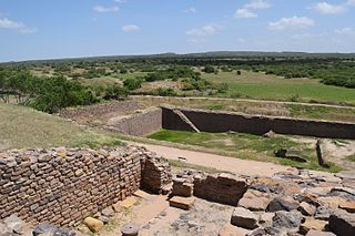
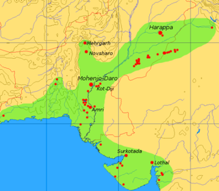
Kuntasi is an archaeological site (locally known as Bibi-no-Timbo) which is identified as a port belonging to the Indus Valley civilization. [1] This site is located on the right bank of Phulki River, about 2 km south-east of Kuntasi village [2] and 30 km from Morbi in Maliya taluka of Morbi District in Gujarat state of India. [3] It is five km inlandward from present shore line. It was first reported by P. P Pandya and later thoroughly explored by Y. M. Chitalwala. The excavations revealed two periods of occupation. Period I is assigned to the Mature Harappan phase (c. 2200–1900 BCE) and the Period II is assigned to the Late Harappan phase (c.1900–1700 BCE). [4] This site was identified as a jetty and a manufacturing centre. [5]

Contents

Area

Kuntasi had 2 hectares of walled town and unwalled suburbs. [6] A stone platform ran along the western side of wall. It appears to have been a planned settlement, established for production, storage and movement of goods. [7]

Architecture

The excavated site consists of two parts, a two hectare walled settlement and unwalled suburbs. A stone platform ran along the western side of the wall, and adjoining this inside the walled town were a substantial industrial complex and a number of storage facilities. A centrally placed house with a number of rooms, including a private kitchen was found. Other houses lay in the north and west of the walled area, mostly large rectangular buildings. The houses in Kuntasi were built on stone foundations with walls of mud bricks in Harappan proportion but unusually large. In the southwestern corner, a large isolated room was found, which has been identified as a kitchen serving most of the settlement. The buildings were arranged around a large open space. However, the town of Kuntasi lacked Citadel which was prominent in bigger towns like Kalibangan, Dholavira, Banawali etc. belonging to Indus Valley Civilisation. [8] A jetty (platform) for unloading and loading cargo on the boats going down the creek is also identified. [3]

Double wall

Kuntasi had a double wall, built out of boulders and mud, separated by a passage with a width of about 20 meters. [9] Southwestern corner of town had a tower, and eastern side had a gate flanked by guard chambers, presumably to control public access to the walled area. [10]

Artifacts found

Pottery with drawings were found. Two cylindrical stone anchors, suggesting seaborne activity was also found. [11] A small pot with copper hoard, few copper bangles, two finger rings and more than thousand micro beads of steatite were also found. Other artifacts include cubical chart weights, tools made of bones, terracotta toy carts, agate and carnelian goods. [3]

Importance

Kuntasi was similar to Lothal, another port town of IVC, though on a smaller scale. [12] Lapis Lazuli was found in unusual large quantity in this settlement, indicating that it was exported to Mesopotamia, as lapis lazuli was known to have been an important export item from IVC to Mesopotamia. [13] It is also suggested that a land route connected this site to Lothal via Rangpur, Gujarat. [14]

See also

Notes

  1. McIntosh, Jane (2008). The Ancient Indus Valley : New Perspectives. Santa Barbara, California: ABC-CLIO. p. 173. ISBN   9781576079072.
  2. Gaur, A.S.and K.H. Vora (10 July 1999). "Ancient shorelines of Gujarat, India, during the Indus civilization (Late Mid-Holocene): A study based on archaeological evidences". Current Science.
  3. 1 2 3 Mehta, Makrand (2009). "Echoes from the Lothal - Harappan Civilization". History of International Trade and Customs Duties in Gujarat. Vadodara: Darshak Itihas Nidhi. p. 29. OCLC   439922062.
  4. Ray, Niharranjan (gen. ed.) (2000). A Sourcebook of Indian Civilization, Kolkata: Orient Longman, ISBN   81-250-1871-9, p.569
  5. McIntosh, Jane (2008). The Ancient Indus Valley : New Perspectives. Santa Barbara, California: ABC-CLIO. p. 173. ISBN   9781576079072.
  6. McIntosh, Jane.(2008) The Ancient Indus Valley, New Perspectives. ABC-CLIO. Page 220
  7. McIntosh, Jane.(2008) The Ancient Indus Valley, New Perspectives. ABC-CLIO. Page 221
  8. McIntosh, Jane.(2008) The Ancient Indus Valley, New Perspectives. ABC-CLIO. Page 226
  9. McIntosh, Jane.(2008) The Ancient Indus Valley, New Perspectives. ABC-CLIO. Page 224
  10. McIntosh, Jane.(2008) The Ancient Indus Valley, New Perspectives. ABC-CLIO. P 224
  11. Ancient shorelines of Gujarat, India, during the Indus civilization (Late Mid-Holocene): A study based on archaeological evidences by A. S. Gaur and K. H. Vora.Marine Archaeology Centre, National Institute of Oceanography,
  12. McIntosh, Jane (2008). The Ancient Indus Valley : New Perspectives. Santa Barbara, California: ABC-CLIO. p. 173. ISBN   9781576079072.
  13. McIntosh, Jane (2008). The Ancient Indus Valley : New Perspectives. Santa Barbara, California: ABC-CLIO. p. 173. ISBN   9781576079072.
  14. McIntosh, Jane (2008). The Ancient Indus Valley : New Perspectives. Santa Barbara, California: ABC-CLIO. p. 173. ISBN   9781576079072.

Related Research Articles

<span class="mw-page-title-main">Dholavira</span> Indus Valley Civilization site in Gujarat, India

Dholavira is an archaeological site at Khadirbet in Bhachau Taluka of Kutch District, in the state of Gujarat in western India, which has taken its name from a modern-day village 1 kilometre (0.62 mi) south of it. This village is 165 km (103 mi) from Radhanpur. Also known locally as Kotada timba, the site contains ruins of a city of the ancient Indus Valley civilization. Earthquakes have repeatedly affected Dholavira, including a particularly severe one around 2600 BC.

Sutkagan Dor is the westernmost known archaeological site of the Indus Valley civilization. It is located about 480 km west of Karachi on the Makran coast near Gwadar, close to the Iranian border, in Pakistan's Baluchistan Province. The site is near the western bank of the Dasht River and its confluence with a smaller stream, known as the Gajo Kaur. It was a smaller settlement with substantial stone walls and gateways.

Rangpur is an ancient archaeological site near Vanala on Saurashtra peninsula in Gujarat, western India. Lying on the tip between the Gulf of Khambhat and Gulf of Kutch, it belongs to the period of the Indus Valley civilization, and lies to the northwest of the larger site of Lothal. It is the type site for the Rangpur culture, a regional form of the late phase of the Indus Valley Civilization that existed in Gujarat during the 2nd millennium BCE.

Chanhu-daro is an archaeological site belonging to the Indus Valley civilization. The site is located 130 kilometers (81 mi) south of Mohenjo-daro, in Sindh, Pakistan. The settlement was inhabited between 4000 and 1700 BCE, and is considered to have been a centre for manufacturing carnelian beads. This site is a group of three low mounds that excavations has shown were parts of a single settlement, approximately 7 hectares in size.

<span class="mw-page-title-main">Surkotada</span> Archeological site in Kutch, Gujarat, India

Correct coordinates are: 23.6113°N, 70.9173°E

<span class="mw-page-title-main">Shortugai</span> Trading colony of the Indus Valley Civilization established around 2000 BC

Shortugai (Shortughai), in Darqad District of northern Afghanistan, was a trading colony of the Indus Valley civilization established around 2000 BC on the Oxus river near the lapis lazuli mines. It is considered to be the northernmost settlement of the Indus Valley Civilization. According to Bernard Sergent, "not one of the standard characteristics of the Harappan cultural complex is missing from it".

<span class="mw-page-title-main">Pirak</span>

Pirak is an archaeological site belonging to the Indus Valley civilization located in Balochistan, Pakistan. It is 20 km south of Sibi east of the Nari River. The mound is 8m high and covers approximately 12 acres (49,000 m2). The site of Pirak was first reported by Robert Raikes in 1963. It was excavated, between 1968 and 1974, before the well known sites of Mehrgarh or Nausharo by the French archaeological mission team led by Jean Marie Casal. According to the excavator, this site was occupied from c.1800 BCE to 800 BCE.

Banawali is an archaeological site belonging to Indus Valley civilization period in Fatehabad district, Haryana, India and is located about 120 km northeast of Kalibangan and 16 km from Fatehabad. Banawali, which is earlier called Vanavali, is on the left banks of dried up Sarasvati River. Comparing to Kalibangan, which was a town established in lower middle valley of dried up Sarasvathi River, Banawali was built over upper middle valley of Sarasvati River.

Gola Dhoro is an archaeological site belonging to Indus Valley civilization, situated at the head of the Gulf of Kutch, near Bagasara in Kutch district of Gujarat, India. The site contains a small fortified area of approximately 50x50 m with living quarters and manufacturing sites both inside and outside this area.

<span class="mw-page-title-main">Harappan language</span> Language of the Bronze Age civilization of the Indus Valley

The Harappan language is the unknown language or languages of the Bronze Age Harappan civilization. The Harappan script has long defied attempts to read it, and therefore the language remains unknown. The language being unattested in any readable contemporary source, hypotheses regarding its nature are reduced to purported loanwords and substratum influence, notably the substratum in Vedic Sanskrit and a few terms recorded in Sumerian cuneiform, in conjunction with analyses of the undeciphered Indus script.

Manda is a village and an archaeological site in the Jammu district of the Union Territory of Jammu and Kashmir, India. It was excavated by Archaeological Survey of India during 1976-77 by J. P. Joshi. The site contains ruins of an ancient Indus Valley civilization.

Bargaon is an archaeological site of the Indus Valley civilisation. It is in Saharanpur District, Uttar Pradesh, India.

<span class="mw-page-title-main">Allahdino</span>

Allahdino is a small village belonging to the Harappan period, located 40 km east of Karachi. It is an unfortified settlement of 1.4 hectare, established in a coastal area of Pakistan. This small but well organised settlement was abandoned by c. 2000 BCE.

Kerala-no-dhoro(કેરળ-નો-ઢોરો), also known as Padri, is an archaeological site in Gujarat, India. Belonging to the Indus Valley civilisation, it is located on the southern coast of Kathiawar region. Dating from 3699-3792 B.C. known as Padri Culture or Early Harappan period a part of Sorath Harappan, Indus Valley culture.

Loteshwar is a village and an archaeological site belonging to Indus Valley civilisation located at Patan district, Gujarat, India. This site is locally also known as Khari-no-timbo and located on a high sand dune on left bank of Khari river, a tributary of Rupen river.

Kunal is a pre-Harappan Indus Valley civilisation settlement located, just 30 km from Fatehabad City in Fatehabad district of Haryana state in India. Compared to other IVC sites, such as cities like Rakhigarhi and towns like Kalibangan, Kunal site was a village. Excavation at Kunal show 3 successive phases of Pre-Harappan indigenous culture on the Saraswati river who also traded with Kalibanga and Lothal. Kunal, along with its other contemporary sites Bhirrana and Rakhigarhi on Sarasvati-Ghaggar river system, is recognised as the oldest Pre-Harappan settlement, with Kunal being an older cultural ancestor to Rehman Dheri in Pakistan< which is on the Tentative List for future World Heritage Sites.

Pabumath is an Indus Valley civilisation archaeological site near Suvai village in Rapar Taluka of Kutch district, Gujarat, India.

Babar Kot is an archeological site belonging to the Indus Valley civilisation and is located in the Saurashtra region of Gujarat, India. It is 325 km away from Ahmedabad and 152 km away from Bhavnagar and is located in Jafarabad taluka.

Sothi is an early archaeological site of the Indus Valley civilization dating to around 4600BCE, located in the Hanumangarh District of Rajasthan, India, at a distance of about 10 km southwest of Nohar railway station.