
Ratnagiri District is a district in the state of Maharashtra, India. The administrative headquarter of the district is located in the town of Ratnagiri. The district is 11.33% urban. The district is bounded by the Arabian Sea to the west, Sindhudurg district to the south, Raigad district to the north and Satara, Sangli and Kolhapur districts to the east. This district is part of Konkan division.
Sindhudurg district is an administrative district of the Konkan division in India, which was carved out of the erstwhile Ratnagiri district. The district headquarters are located at Oros. The district occupies an area of approximately 5,207 km2 and has a population of 849,651, of which 12.59% were urban. As of 2011, it is the least populous district of Maharashtra.

Khed is a municipal council in the Ratnagiri district of the state of Maharashtra, India. Khed town is situated on the Mumbai - Ratnagiri Highway.
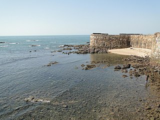
Malvan is a town and taluka in Sindhudurg District, the southernmost district of Maharashtra State, India, well known for the historically important Sindhudurg Fort. Malvan taluka consists of villages such as Angane Wadi, Masure, Achra, Khalchi Devli, Jamdul, Juva, Pankhol, Talasheel, Bandiwade and Sarjekot. The main occupation here is fishing and agriculture. The staple diet of the local people is fish curry and rice. The town produces Alphonso mangoes and is also known for sweets such as Malvani Khaja made from gram-besan flour and coated jaggery as well as Malvani Ladoos. Other sweets that attract tourists are Konkani Meva, Aambawadi, Fanaspoli, Kajuwadi, and Naralachya Wadya.

Mahad ( [məɦaːɖ]) is a city in Raigad district situated in the North Konkan region of Maharashtra state, India. It is located 108.5 km (67.4 mi) from District Headquarters Alibag, and 167 km (104 mi) from Mumbai. Mahad is known for Raigad Fort, the capital of the Maratha Empire in Shivaji's era and the revolutionary Mahad Satyagraha launched by at Chavdar Tale in the wake of modern India.

Gaganbawada is a town situated in the district of Kolhapur in Maharashtra, India. It is located 55 km by road from Kankavli. It is one of the taluka headquarters in Kolhapur district.
Mandangad is the headquarters of Mandangad taluka the northmost taluka in Ratnagiri district of Maharashtra, India.
Sangameshwar Taluka is a taluka in Ratnagiri subdivision of Ratnagiri district in the Indian state of Maharashtra. The headquarters for the taluka is the town of Devrukh. In Sangameshwar the two rivers Sonavi and Shastri flow together. The meaning of Sangama in Marathi is "confluence," and so the name "Sangameshwar". It is historically important as the place where Chhatrapati Sambhaji, son of Chhatrapati Shivaji was captured by Mughal Emperor Aurangzeb. Chhatrapati Sambhaji was tortured and executed in Tulapur.
Vaibhavwadi taluka is a taluka in Kankavli subdivision of Sindhudurg district in the Indian state of Maharashtra.
Sasale is a village in Rajapur taluka, Ratnagiri District, Maharashtra, India. It has many mango, jackfruit and cashew-nut trees. Sasale is situated near Rajapur Road railway station, located around 5 km away. Its population is 1000. The closest town is Rajapur, located 10 km away.

Asoli is a small village in Taluka Vengurla and district Sindhudurg of Maharashtra, India.
Saitavde, or Saitawada, is a small village on the Jaigad creek in Ratnagiri district. It is about 390 km southwest of Mumbai, and about 58 km to the north of Ratnagiri city.
Devrukh is a town in the tehsil of Sangameshwar in the Ratnagiri district of the Indian state of Maharashtra. It is headquarters for the Sangameshwar tehsil and a part of the Konkan region. The town enjoys salubrious climate, and the majority population is involved in agriculture. Summers are warm and winters are not very chilly. Every year Devrukh experiences heavy monsoon. Rice, cashew and alphonso (hapus) mangoes are the major crops in Devrukh.
Argaon, or Argaum is a village in the Ratnagiri district of Maharashtra state in (India). Ratnagiri is a coastal district on the Arabian Seafront. The landmass on the western part of Maharashtra along the Arabian Sea, sandwiched between the sea and a mountain range named Sahyadri, is known as Konkan. Argaon is situated in the foothills of the Sahyadri mountains.
Kurli is a village in Sindhudurg District, the south easternmost district of Konkan Division, Maharashtra, India. Kurli is located 7.9 km from its Taluk Main Town Vaibhavwadi. Kurli is 33.6 km from its District main city, Oras. It is 307 km from its State Main City Mumbai. This is a culturally and historically important village. Kurli consists of wadis like Temb Wadi, Khadakwadi, Bajarpeth. Also it is famous because of the newly made Kurli dam.
Satawali is a census town in Lanja-Taluka Ratnagiri district in the Indian state of Maharashtra.
Rameshwar also known as Rameshwar Wadi is a small town located on the coast of Sindhudurg District of Maharashtra on the west coast of India. A very old Shri Dev Rameshwar Temple is located in this town which is dedicated to the Hindu deity Shiva.
Girye is a small village in Devgad Taluka in Sindhudurg district of the Indian state of Maharashtra. It is located on the west coast of Maharashtra.
Rajapur taluka is a taluka in Ratnagiri district of Maharashtra an Indian state. The temple of Aryadurga devi is located in the Devihasol village in Rajapur taluka.
Chiplun taluka is a taluka in Ratnagiri district of Maharashtra, India. As per Census 2011, there are 2 towns and 165 villages within Chiplun Taluka.

