Kuri, Bhopalgarh

Last updated

Kuri

Kudi
village
India Rajasthan location map.svg
Red pog.svg
Kuri
Location in Rajasthan, India
India location map.svg
Red pog.svg
Kuri
Kuri (India)
Coordinates: 26°39′17″N73°29′45″E / 26.65472°N 73.49583°E / 26.65472; 73.49583 Coordinates: 26°39′17″N73°29′45″E / 26.65472°N 73.49583°E / 26.65472; 73.49583
CountryFlag of India.svg  India
State Rajasthan
District Jodhpur
Tehsil Bhopalgarh
Elevation
308 m (1,010 ft)
Population
 (2011)
  Total3,241
Languages
  Official Marwari
Time zone UTC+5:30 (IST)
ISO 3166 code RJ-IN
Vehicle registration RJ-19

Kuri is a small village located in the Bhopalgarh tehsil of the Jodhpur District of the State of Rajasthan in western India. [1]

Bhopalgarh tehsil tehsil in Rajasthan, India

Bhopalgarh tehsil is a tehsil in Jodhpur District of Rajasthan state in western India. Headquarters for the tehsil is the town of Bhopalgarh. Bhopalgarh tehsil is an eastern tehsil among the 13 tehsils in Jodhpur District. It borders Nagaur District to the north and east, Pipar city tehsil to the south, Jodhpur tehsil to the southwest, and Bawadi tehsil to the west. Bhopalgarh panchayat samiti has 35 gram panchayats & 116 villages. The mineral and the stone used for Emery Stone are found in Bhopalgarh. Rabi crops are mainly cultivated in the Bhopalgarh Tehsil with Bajra, Moong, Moth, Sesamum (Til), Jowar and Cotton being the most common crops. Bhopalgarh tehsil has a total area of 174623.74 hectares with total cultivable area of 63.92% of total area & 21.27% of total cultivable area as irrigated area as per land use 2011. Jats are the dominant community in bhopalgarh. There number vary close to one lakh in the entire constituency.

Rajasthan State in India

Rajasthan is a state in northern India. The state covers an area of 342,239 square kilometres (132,139 sq mi) or 10.4 percent of the total geographical area of India. It is the largest Indian state by area and the seventh largest by population. Rajasthan is located on the northwestern side of India, where it comprises most of the wide and inhospitable Thar Desert and shares a border with the Pakistani provinces of Punjab to the northwest and Sindh to the west, along the Sutlej-Indus river valley. Elsewhere it is bordered by five other Indian states: Punjab to the north; Haryana and Uttar Pradesh to the northeast; Madhya Pradesh to the southeast; and Gujarat to the southwest.

Contents

About

Kuri is a large village in the Bhopalgarh tehsil of the Jodhpur District of the State of Rajasthan, India. It is located 62 km to the east of the Jodhpur District headquarters, 13 km from Bhopalgarh and 277 km from the state capital of Jaipur

Jaipur Metropolis in Rajasthan, India

Jaipur is the capital and the largest city of the Indian state of Rajasthan. As of 2011, the city had a population of 3.1 million, making it the tenth most populous city in the country. Jaipur is also known as the Pink City, due to the dominant color scheme of its buildings. It is located 268 km from the national capital New Delhi.

Kuri Pin code is 342606 and postal head office is Pipar Road. [1]

Near Kuri are the cities of Pipar City, Phalodi, Bilara, and Jodhpur.

Phalodi Town in Rajasthan, India

Phalodi is a town and a municipality in Jodhpur district in the Indian state of Rajasthan. It is the headquarters for Phalodi tehsil. Phalodi is also called the "salt city" due to the salt industry in Rin. Phalodi is in the buffer zone of Thar Desert and often subject to extreme temperature conditions due to arid climate. It holds the record for the highest verified temperature recorded in India at 51 °C (124 °F) on 19 May 2016.

Bilara city in Rajasthan, India

Bilara is a city and a municipality located in the Jodhpur district of Rajasthan, India. It is the administrative headquarters for Bilara tehsil and a market center for the surrounding agricultural area.

Jodhpur City in Rajasthan, India

Jodhpur is the second-largest city in the Indian state of Rajasthan and officially the second metropolitan city of the state. It was formerly the seat of a princely state of the same name. Jodhpur was historically the capital of the Kingdom of Marwar, which is now part of Rajasthan. Jodhpur is a popular tourist destination, featuring many palaces, forts and temples, set in the stark landscape of the Thar Desert. It is popularly known as Blue city and Sun city among people of Rajasthan and all over India.

Population

According to 2011 census, the Kuri population is

Male Population 1675
Female Population 1566
Total Population 3241

Language

Marwari is the dominant local language and Hindi is used.[ citation needed ]

Marwari is a Rajasthani language spoken in the Indian state of Rajasthan. Marwari is also found in the neighboring state of Gujarat and Haryana, Eastern Pakistan and some migrant communities in himalayan country Nepal. With some 7.9 million or so speakers, it is one of the largest varieties of Rajasthani. Most speakers live in Rajasthan, with a quarter million in Sindh and a tenth that number in Nepal. There are two dozen dialects of Marwari.

Hindi Indo-Aryan language spoken in India

Hindi or Modern Standard Hindi, is a standardised and Sanskritised register of the Hindustani language. In India, the official standardized variety of the language is based primarily on the Khariboli dialect of Delhi and other nearby areas of northern India. Hindi, written in the Devanagari script, is one of the two official languages of the Government of India, along with the English language. It is one of the 22 scheduled languages of the Republic of India. Contrary to the popular belief, Hindi is not the national language of India because no language was given such a status in the Indian constitution.

Geography

It is among the larger villages of the area:

Tambariya Kalan (8 km)
Bhundana (9 km)
Malar (9 km)
Kagal (10 km)
Dewatra (11 km)
Sopra (6 km)

Surrounding Kuri is:

West - Mandor tehsil
West - Jodhpur tehsil
South - Bilara tehsil
East - Kharchi (Mar.Jun) tehsil
Nathji Bhakar Gunjiya mata mandir,Nathji bhakar,Kuri.jpg
Nathji Bhakar
Nathji Bhakar Nathji Bhakar.jpg
Nathji Bhakar

Transportation

By Road

State highway 65 from Jodhpur

By Rail

Sathin Road railway station is the very nearby railway station to Kuri. However Mahamandir railway station is major railway station 55 km near to Kuri.

Schools in Kuri

Temples in Kuri

Village is inhabited by mostly Hindus along with a few Islam followers.

There are many temples in the village spread across its length and breadth dedicated to various Gods and Goddesses. But the main temple is dedicated to a great Shiva follower, Shri Sujannathji Maharaj, located in the older heart of village. It has transformed from being just an ordinary main sanctum to full fledged place for public discussions. A lively place, visited by villagers occasionally.

Among other important temples are,

and many small chattris spread around.

Over the hill (Nathji Bhakar) located on the outskirts of the village, on Sopra-Kuri boundary, is a remarkable recently built temple dedicated to 'Gunjiya Mata' along with the cave where Shri sujannathji use to meditate.

Related Research Articles

Ranakpur Rural in Rajasthan, India

Ranakpur is a village located in Desuri tehsil near Sadri town in the Pali district of Rajasthan in western India. It is located between Jodhpur and Udaipur. 162 km from Jodhpur and 91 km from Udaipur, in a valley on the western side of the Aravalli Range. The Nearest Railway Station to reach Ranakpur is Falna and Rani railway station. Ranakpur is one of the most famous places to visit in Pali, Rajasthan. Ranakpur is easily accessed by road from Udaipur.

Beawar City in Rajasthan, India

Beawar is a city in Ajmer district of Rajasthan, India. Beawar was the financial capital of Merwara state of Rajputana. As of 2011, the population of Beawar is 342,935. It is located 184 kilometres (114 mi) southwest of the state capital Jaipur, amidst Aravali hills. The city used to be a major center of trade, especially in raw cotton, and used to have cotton presses and the Krishna cotton mills. Currently, major industries include mineral-based units, machine-based units, machine tools and accessories, pre-stressed concrete pipes, plastic products, textiles, wooden furniture and asbestos cement pipes. Beawar is the largest producer of cement in northern India and home to Shree Cement. It is situated in a mineral-rich region having reserves of feldspar, quartz, asbestos, soapstone, magnesite, calcite, limestone, mica, emerald, granite, and masonry stone. Reserves of barytes, fluorite, wollastonite and vermiculite have also been found. Nearest airports are Jodhpur (145 km) and Jaipur (190 km). It is also connected by RSRTC operated buses to all parts of Rajasthan, and neighboring Delhi NCR, Ahmedabad (Gujarat), Gwalior. It also had railway connectivity with Delhi, Mumbai, Ahmadabad, Bangalore (bi-weekly), Haridwar, Dehradun (weekly), Bareilly and Kolkata.

Pali district District in Rajasthan, India

Pali District is a district of the state of Rajasthan in western India.The town of Pali is the district headquarters.

Jodhpur district District of Rajasthan in India

Jodhpur District is a district in the State of Rajasthan in western India. The city of Jodhpur is the administrative headquarters of the district.

Karni Mata Hindu sage

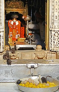
Karni Mata was a female Hindu warrior sage born in the Charan caste. Also known as Shri Karniji Maharaj, she is worshiped as the incarnation of the warrior goddess Durga by her followers. She is an official deity of the royal families of Jodhpur and Bikaner. She lived an ascetic life and was widely revered during her own lifetime. At the request of the Maharajas of Bikaner and Jodhpur, she laid the foundation stones of Bikaner Fort and Mehrangarh Fort, the two most important forts in the region. The most famous of her temples is in the small town of Deshnoke, near Bikaner in Rajasthan, and was created following her mysterious disappearance from her home. The temple is famous for its white rats, which are treated as sacred and given protection in the temple. Another temple dedicated to her during her lifetime differs from others in that it does not contain an image or idol of her, but rather a footprint to symbolize her visit to that place. Karni Mata is also known as “dadi wali dokri.

Nakoda village in Rajasthan, India

Nakoda Mewanagar is a village in the Barmer District of Indian state of Rajasthan. The village name is Mewanagar in the Rajasthan state Government records.

Falna Town in Rajasthan, India

Falna is a town in Pali District in Indian state of Rajasthan. It is an important railway station on Ahmedabad-Jaipur railway line. Falna is 75 km from the district headquarters of Pali.

Balotra City in Rajasthan, India

Balotra is a city in Barmer District of Rajasthan state in India. It is about 91 km from Jodhpur. The town is known for hand block printing and textile industry and for an annual desert and tribal fair at Tilwara. The town is well connected with Jodhpur by rail and buses at frequent intervals. From Balotra towards Jalore (14 km) there is India's Third Brahma Temple in the village of Asotra. From Balotra towards Barmer (11 km) there is Ancient Temple of Lord Shri Vishnu named as Shri Ranchore Ray, Khed Mandir in the village of Khed The name Balotra derived from valaji or balaji SIHA Rajpurohit. A few hundred years ago Khed was the capital of the Rathores of western Rajasthan, whose influence extended over the entire region. It was at the beginning of the 13th century that the Rathore king Rao Sihaji the founder of the Rathore clan along with his son (Asthanji) conquered Khed from the Guhil Rajputs and planted the standard of the Rathores. Balotra was ruled by the Morsiya's for more than 300 years. The Rani Bhatiyaniji temple is also here in village named Jasol 4 km from Balotra. Kheteshwar Palna Dham temple is located in village Sarana,12 km away from Balotra. Sarana village is the birthplace of Shri Khetaram Ji Maharaj. About 13 km away from Balotra is located the Jain Temple Nakoda. The place receives religious devotees from across India. The town is home to more than 5,000 textile units and is located on the coast of the river Luni.

Takhatgarh city in Rajasthan, India

Takhatgarh is a town in Sumerpur tehsil of Pali District of Rajasthan state in India. The town is one of the nine municipalities in the district, located near the district border. It is only about 150 years old.

Piparcity is a town and a municipality in Jodhpur district in the Indian state of Rajasthan. It is located on Jodhpur - Merta City state highway. It has a government women's college - Smt. Sita Dewi Chunni Lal Bardiya Mahila Mahavidyalay, three senior secondary level government schools along with other private colleges and schools.

Rani, Rajasthan city in Rajasthan, India

Rani is a town and municipality and subdistrict of Pali district in the Indian state of Rajasthan. It lies on the banks of Sukri River, a tributary of the Luni River. It is an important railway station on Ahmedabad-Delhi railway line.

Degana Town in Rajasthan, India

Degana is a town municipality and headquarter to Sub-Division and Tehsil located in Nagaur district of Rajasthan, India.

Bamnera village in Rajasthan, India

Bamnera is a village situated in Sumerpur tehsil of Pali District in the state of Rajasthan on the Beawar- Radhanpur National Highway No. 14 and the nearest railway station is Jawai Bandh.

Bilara tehsil tehsil in Rajasthan, India

Bilara tehsil is a tehsil in Jodhpur District of Rajasthan state in western India. The tehsil headquarters are in the town of Bilara.

Sopra, Bhopalgarh village in Rajasthan, India

Sopra is a village located in the Bhopalgarh tehsil of Jodhpur District, Rajasthan, India.

Dhandhaniya sasan Place in Rajasthan, India

Dhandhaniya Sasan is a village in Dhandhaniya, Jodhpur district, Rajasthan, India.

Malar, Bhopalgarh Village panchayat in Rajasthan, India

Malar village is located in Bhopalgarh Tehsil of Jodhpur district in Rajasthan, India. It is situated 30km away from sub-district headquarter Bhopalgarh and 66km away from district headquarter Jodhpur. As per 2009 stats, Malar village is also a gram panchayat. The total geographical area of village is 1217.47 hectares. Malar has a total population of 1,912 people. There are about 387 houses in Malar village. Pipar City is nearest town to Malar which is approximately 12km away. According to Census 2011 information the location code or village code of Malar village is 084862.

References

  1. 1 2 "Village Panchayat Names of BHOPALGARH, JODHPUR, RAJASTHAN". panchayatdirectory.gov.in. Archived from the original on 16 May 2013. Retrieved 3 January 2014.