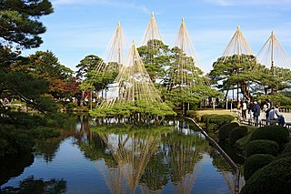
Ishikawa Prefecture is a prefecture of Japan located in the Chūbu region of Honshu island. Ishikawa Prefecture has a population of 1,140,573 and has a geographic area of 4,186 km2. Ishikawa Prefecture borders Toyama Prefecture to the east, Gifu Prefecture to the southeast, and Fukui Prefecture to the south.

Hydroelectricity, or hydroelectric power, is electricity generated from hydropower. Hydropower supplies one sixth of the world's electricity, almost 4500 TWh in 2020, which is more than all other renewable sources combined and also more than nuclear power. Hydropower can provide large amounts of low-carbon electricity on demand, making it a key element for creating secure and clean electricity supply systems. A hydroelectric power station that has a dam and reservoir is a flexible source, since the amount of electricity produced can be increased or decreased in seconds or minutes in response to varying electricity demand. Once a hydroelectric complex is constructed, it produces no direct waste, and almost always emits considerably less greenhouse gas than fossil fuel-powered energy plants. However, when constructed in lowland rainforest areas, where part of the forest is inundated, substantial amounts of greenhouse gases may be emitted.

Teesta River is a 414 km (257 mi) long river that rises in the Pauhunri Mountain of eastern Himalayas, flows through the Indian states of Sikkim and West Bengal and subsequently enters Bangladesh through Rangpur division. In Bangladesh, it falls into Brahmaputra River which after meeting some other major rivers of Bengal delta finally falls into the Bay of Bengal. It drains an area of 12,540 km2 (4,840 sq mi). In India, it flows through Mangan District, Gangtok District, Pakyong District, Kalimpong district, Darjeeling District, Jalpaiguri District, Cooch Behar districts and the cities of Rangpo, Jalpaiguri and Mekhliganj. In Bangladesh, it flows through Lalmonirhat District, Rangpur District, Kurigram District and Gaibandha District. It joins the Brahmaputra River at Phulchhari Upazila in Bangladesh. 305 km (190 mi) of the river lies in India and 109 km (68 mi) in Bangladesh. Teesta is the largest river of Sikkim and second largest river of West Bengal after the Ganges.

The Tekezé or Täkkäze River, also spelled Takkaze, is a major river of Ethiopia. For part of its course it forms a section of the westernmost border of Ethiopia and Eritrea. The river is also known as the Setit in Eritrea, western Ethiopia, and eastern Sudan. According to materials published by the Ethiopian Central Statistical Agency, the Tekezé River is 608 kilometers (378 mi) long. The canyon which it has created is the deepest in Africa and one of the deepest in the world, at some points having a depth of over 2000 meters.

The Swat River is a perennial river in the northern region of the Khyber-Pakhtunkhwa Province of Pakistan. The river's source is in the high glacial valleys of the Hindu Kush mountains, where it then flows into the Kalam Valley before forming the spine of the wider Swat valley – an important tourist destination in northern Pakistan, and former stronghold of the ancient Gandhara region with numerous ancient Buddhist sites scattered through the region.

The Murat River, also called Eastern Euphrates, is a major source of the Euphrates River. The Ancient Greeks and Romans used to call the river Arsanias. It originates near Mount Ararat north of Lake Van, in Eastern Turkey, and flows westward for 722 km (449 mi) through mountainous area. Before the construction of the Keban Dam, the Murat River joined the Karasu River or Western Euphrates 10 km (6.2 mi) north of the dam site and 13 km (8.1 mi) north of the town of Keban.

The White Ring, officially Nagano City Mashima General Sports Arena, is an indoor sporting arena located in Nagano, Japan. The capacity of the arena is 7,000 people.
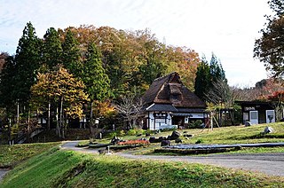
Yunokuni no Mori (ゆのくにの森) is a crafts village in Komatsu, a city located in the southern portion of Ishikawa Prefecture in Japan. It is located near Awazu Onsen amid over one hundred acres of natural forest, and contains a cluster of traditional Japanese houses, each containing a working display of traditional handicrafts native to the Hokuriku region of Japan.
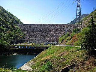
Miboro Dam is a dam on the Shō River in Shirakawa, in Gifu Prefecture Japan. It supports a 256 MW hydroelectric power station. Of the nine dams on the Shō River, it is the furthest upstream.
Novohuivynske is an urban-type settlement in Zhytomyr Raion, Zhytomyr Oblast, Ukraine. Population: 5,240 In 2001, population was 5,267.
Çakmak Dam is a dam in Samsun Province, Turkey. Its reservoir has been found to house Capoeta tinca, a species of scraper, as well as 136 recorded taxa of phytoplankton, with members of the phylum Chlorophyta dominant in population density, and Bacillariophyta dominant in terms of species richness. The dam is a source of water for the city of Samsun.
Chetimari is a large village and rural commune in Niger, located along National Highway 1, several kilometres north of the Nigerian border. As of 2011, the commune had a total population of 66,845 people.

Latour is a resort in Suriname, located in the Paramaribo District. Its population at the 2012 census was 29,526. Latour is a low income neighbourhood with large unemployment. Latour is the most populous resort of Paramaribo.
The Qingshui River is a tributary of the Wu River in Guizhou Province, China. It is interrupted by the Dahuashui Dam.

The Okutadami Dam (奥只見ダム) is a concrete gravity dam on the Tadami River, 26 km (16 mi) east of Uonuma on the border of Niigata and Fukushima Prefectures, Japan. The primary purpose of the dam is hydroelectric power generation and it supports a 560 MW power station which is the largest conventional hydroelectric power station in Japan. The dam also forms the second largest reservoir in Japan, next to that of the Tokuyama Dam.
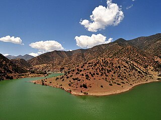
The Sous River, Sus River or Souss River is a river in mid-southern Morocco located in the Sous region. It originates in the High Atlas and flows west passing Aoulouz, Taroudannt, Oulad Teima, Inezgane and Aït Melloul. It forms a basin which is protected from the desertic climate of the Sahara by the Anti-Atlas mountains and is one of Morocco's most fertile regions.
Hydroelectricity is a major source of electricity in Turkey, due to its mountainous landscape and many rivers. The country's main river basins are the Euphrates and Tigris. Over 700 hydropower plants have been built, and they make up about 30% of the country's electricity generating capacity. Annual generation varies greatly, and in rainy years lots of hydroelectric power can be generated. Government policies have generally supported building dams, but some are controversial in neighbouring countries, and some raise concerns about damage to the environment and wildlife.
The Renzonghai Dam is a rock-fill embankment dam on the Tianwanhe River, a tributary of the Dadu River, in Shimian County of Sichuan Province, China. The primary purpose of the dam is hydroelectric power generation and it supports three power stations downstream, the Renzonghai, Jinwo and Dafa Hydropower Stations. Water from the dam is sent via penstock first to the 246 MW Renzonghai then the 287.2 MW Jinwo and finally, the 246 MW Dafa Hydropower Station. The total installed capacity of the power stations is 779.2 MW Construction on the project began in August 2004 and the Jinwo power station was commissioned in 2007, the Dafa in 2008 and the Renzonghai in 2009. The Jinwo station contains the largest Pelton turbines in Asia, two at 146.3 MW each.

Yılanlı Ada is a small Mediterranean island in Turkey.

