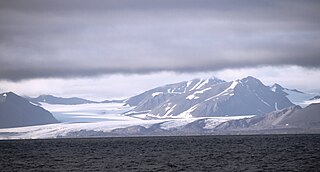
Kvitbreen (White Glacier) is a glacier in Ny-Friesland at Spitsbergen, Svalbard. It located south of Newtontoppen, and is connected with the glacier of Veteranen at the other side of Trebrepasset. [1] [2]

Kvitbreen (White Glacier) is a glacier in Ny-Friesland at Spitsbergen, Svalbard. It located south of Newtontoppen, and is connected with the glacier of Veteranen at the other side of Trebrepasset. [1] [2]

Olav V Land is a peninsula in eastern Spitsbergen Island, Svalbard named after Olav V of Norway. It is covered by the Olav V Icefield, measuring about 4,150 square kilometres (1,600 sq mi).

Oscar II Land is the land area between Isfjorden and Kongsfjorden on Spitsbergen, Svalbard. The 30 km (19 mi) long glacier Sveabreen divides Oscar II Land from James I Land.

Sabine Land is a land area on the east coast of Spitsbergen, Svalbard. It is named after explorer General Sir Edward Sabine. Among the glaciers in the area is the 250-square-kilometer (97 sq mi) Nordmannsfonna glacier.

James I Land is a land area on the northwestern part of Spitsbergen, Svalbard. It is named after King James I of England and Scotland. The 30 kilometer long glacier Sveabreen divides James I Land from Oscar II Land.
Barentsjøkulen is a glacier on Barentsøya, Svalbard. The glacier covers an area of about 571 km2 (220 sq mi). It is named after the Barents Island, which again is named after Dutch explorer Willem Barentsz. Barents Island is on the Barents Sea.
St. Jonsfjorden is a fjord in Oscar II Land at Spitsbergen, Svalbard. It has a length of 21 kilometer, and opens westwards into the strait of Forlandsundet. Several glaciers debouche into the fjord, including Gaffelbreen and Konowbreen from the north, a merge of Osbornebreen, Devikbreen, Vintervegen, Paulbreen and Bukkebreen at the bottom, and Vegardbreen, Charlesbreen and Bullbreen from the south.
Osbornebreen is a glacier in Oscar II Land at Spitsbergen, Svalbard. It has a length of 21 kilometers, merges with the glaciers Devikbreen, Klampebreen and Vintervegen, and debouches into St. Jonsfjorden. The mountain ridge Goldschmidtfjella forms a six kilometer long nunatak in the glacier.
Vintervegen is a glacier in Oscar II Land at Spitsbergen, Svalbard. It has a length of about 7.5 kilometers (4.7 mi). The glacier borders to the mountain of Klampen, merges with Osbornebreen and other glaciers, and the merged glacier stream debouches into the head of St. Jonsfjorden.
Tunabreen is a glacier stream at Spitsbergen, Svalbard. The glacier is about 23 kilometers long, and divides Sabine Land from Bünsow Land. It starts from Lomonosovfonna, flows southwards between the mountains of Langtunafjella and Ultunafjella, merges with Von Postbreen, and the combined glacier debouches into Tempelfjorden.
Sveigbreen is a glacier stream in Sabine Land at Spitsbergen, Svalbard. It has a length of about eleven kilometers, and extends the southern part of the ice cap Hellefonna, south of Kropotkinfjellet. The glacier is one of the two main sources to the river Agardhelva, which flows through Agardhdalen towards Agardhbukta.
Sefströmbreen is a glacier in James I Land at Spitsbergen, Svalbard. It is debouching into Ekmanfjorden at the northern side of Isfjorden. The glacier is named after Nils Gabriel Sefström. During a surge in 1896 the glacier deposited large moraine ridges in the inner part of the fjord, and these can be seen at the islands of Coraholmen and Flintholmen. Sefströmbreen is included in the Nordre Isfjorden National Park.

Petuniabukta is a bay in Dickson Land at Spitsbergen, Svalbard. It constitutes the northern branch of Billefjorden. The bay is named after the Scottish vessel SS Petunia. Northwest of the bay is the valley of Hørbyedalen and the glacier of Hørbyebreen.

Eidembreen is a glacier in Oscar II Land at Spitsbergen, Svalbard. It has a length of about eighteen kilometers, and debouches into Eidembukta in Forlandsundet, between St. Jonsfjorden and Isfjorden. The glacier is named after Norwegian politician and naval officer Ole Thorenius Eidem. Eidembreen belongs to the mountain and glacier complex of Trollheimen. Further north are Austgötabreen and Huldrebreen, and to the south are Stallobreen and Heksebreen.
Aldegondabreen is a glacier in Nordenskiöld Land at Spitsbergen, Svalbard. It is named after Infanta Adelgundes, Duchess of Guimarães. The glacier has a length of about 5.5 kilometers. It flows from Qvigstadfjellet, Christensenfjella and Hermod Petersenfjellet towards Grønfjorden.
Hayesbreen is a glacier in Sabine Land at Spitsbergen, Svalbard. It is named after American politician and Arctic explorer Isaac Israel Hayes. The glacier has a length of about eighteen kilometers, and debouches into the bay of Mohnbukta. Surrounding mountains are Aagaardfjellet to the north, Jebensfjellet to the south, and Panofskyfjellet where Hayesbreen joins the glacier of Königsbergbreen.
Langlifjellet is a mountain in Nathorst Land at Spitsbergen, Svalbard. It has peaks with heights of 1,011, 973 and 885 m.a.s.l. respectively. The mountain is surrounded by the mountains of Sven Nilssonfjellet, Bassøefjellet, and Steindolptoppen, and the glaciers of Løyndbreen, Lundbreen and Langlibreen. The valley of Langlidalen separates Langlifjellet and Sven Nilssonfjellet from the mountain of Rånekampen.
Christensenfjella is a mountain in Nordenskiöld Land at Spitsbergen, Svalbard. It is named after Norwegian shipowner Christen Christensen. The mountain has several peaks, the highest is 682 m.a.s.l. It is located east of Systemafjellet and north of Orustdalen, and is proximate to the glaciers of Aldegondabreen and Linnébreen.
Chydeniusfjella is a mountain group in Ny-Friesland at Spitsbergen, Svalbard. It is named after Finnish physicist Jakob Karl Emil Chydenius. The mountain group is located between Wijdefjorden and Hinlopen Strait, and is surrounded by the glaciers of Ermakbreen, Harlandisen, Veteranen, Glasgowbreen and Kvitbreen. Among the mountains of the group is Newtontoppen.
Kroghfjellet is a mountain in Sabine Land at Spitsbergen, Svalbard. It is located west of the bay of Mohnbukta and south of the glacier of Hayesbreen. The mountain has a length of about five kilometers. It is named after a German consul in Tromsø in the 1870s. The glacier of Usherbreen is located between Kroghfjellet and Domen.
Coordinates: 78°58′23″N17°32′02″E / 78.973°N 17.534°E