Kyle Rhea

Last updated

Kyle Rhea
Arriving at Kylerhea (geograph 3588320).jpg
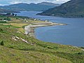
The ferry MV Glenachulish on Kyle Rhea, beside Kylerhea pier. This view is looking north
Isle of Skye UK location map.svg
Red pog.svg
Location of Kyle Rhea
Location
CountryScotland
County Highlands
Physical characteristics
Source 
  coordinates 57°10′47″N5°42′06″W / 57.179613°N 5.701599°W / 57.179613; -5.701599
Mouth  
  coordinates
57°15′17″N5°38′28″W / 57.254828°N 5.641010°W / 57.254828; -5.641010 Coordinates: 57°15′17″N5°38′28″W / 57.254828°N 5.641010°W / 57.254828; -5.641010
Length6.0 mi (9.7 km)

Kyle Rhea is a strait of water in the Highland area of Scotland. It runs from the Inner Seas off the West Coast of Scotland in the southwest to Loch Alsh in the northeast, separating the Isle of Skye from Inverness-shire on the Scottish mainland. [1] [2] It gave its name to Kylerhea, a village on its western shore.

Contents

Loch Hourn branches off to the east at about its midpoint.

Just north of Kylerhea, a ferry service has linked the village with Glenelg on the mainland for centuries. The first car ferry [3] was introduced in 1935, with a turntable located on the boat. Despite the existence of the now toll-free Skye Bridge, this ferry service, undertaken by the MV Glenachulish, still runs during the summer months, due to its popularity as the more scenic and traditional route between Skye and the mainland. This service is now community-owned but used to be run by Murdo Mackenzie for almost twenty years.

Kyle Rhea is mentioned in Sir Thomas Dick Lauder's novel Highland Legends. [4]

Related Research Articles

<span class="mw-page-title-main">Ross and Cromarty</span> Area in the Highlands and Islands of Scotland

Ross and Cromarty, also referred to as Ross-shire and Cromartyshire, is a variously defined area in the Highlands and Islands of Scotland. There is a registration county and a lieutenancy area in current use, the latter of which is 8,019 square kilometres in extent. Historically there has also been a constituency of the Parliament of the United Kingdom, a local government county, a district of the Highland local government region and a management area of the Highland Council. The local government county is now divided between two local government areas: the Highland area and Na h-Eileanan Siar. Ross and Cromarty border Sutherland to the north and Inverness-shire to the south.

<span class="mw-page-title-main">Ross, Scotland</span>

Ross is a region of Scotland. One of the provinces of Scotland from the 9th century, it gave its name to a later earldom and to the counties of Ross-shire and, later, Ross and Cromarty. The name Ross allegedly derives from a Gaelic word meaning "headland", perhaps a reference to the Black Isle. Another possible origin is the West Norse word for Orkney – Hrossey – meaning horse island; the area once belonged to the Norwegian earldom of Orkney. Ross is a historical comital region, perhaps predating the Mormaerdom of Ross. It is also a region used by the Kirk, with the Presbytery of Ross being part of the Synod of Ross, Sutherland and Caithness.

<span class="mw-page-title-main">A87 road</span> Major road through the Highland region of Scotland

The A87 is a major road in the Highland region of Scotland.

<span class="mw-page-title-main">Kyle of Lochalsh</span> Human settlement in Scotland

Kyle of Lochalsh is a village in the historic county of Ross-shire on the northwest coast of Scotland, located around 55 miles (90 km) west-southwest of Inverness. It is located on the Lochalsh peninsula, at the entrance to Loch Alsh, opposite the village of Kyleakin on the Isle of Skye. A ferry used to connect the two villages until it was replaced by the Skye Bridge, about a mile (2 km) to the west, in 1995.

Lochalsh is a district of mainland Scotland, currently part of the Highland council area

<span class="mw-page-title-main">Kyles of Bute</span> Channel in Argyll and Bute, Scotland, UK

The Kyles of Bute form a narrow sea channel that separates the northern end of the Isle of Bute from the Cowal peninsula in Argyll and Bute, on the Scottish mainland. The surrounding hillsides are roughly wooded, and overlooked by rocky tops and areas of moorland.

<span class="mw-page-title-main">Kyle of Lochalsh line</span> Railway line in the Scottish Highlands

The Kyle of Lochalsh line is a primarily single-track railway line in the Scottish Highlands, from Dingwall to Kyle of Lochalsh. Many of the passengers are tourists, but there are also locals visiting Inverness for shopping, and commuters. All services are provided by ScotRail and run beyond Dingwall to Inverness. In the past there were some through services to and from Glasgow, Edinburgh or Aberdeen. None of the line is electrified, and all trains on the line are diesel-powered, as are all other trains in the Scottish Highlands.

<span class="mw-page-title-main">Glenelg, Highland</span> Human settlement in Scotland

Glenelg (Scottish Gaelic: Glinn Eilg, also Gleann Eilg is a scattered community area and civil parish in the Lochalsh area of Highland in western Scotland. Despite the local government reorganisation the area is considered by many still to be in Inverness-shire, the boundary with Ross-shire being at the top of Mam Ratagan the single-track road entry into Glenelg.

<span class="mw-page-title-main">Kyleakin</span> Human settlement in Scotland

Kyleakin is a village situated on the east coast of the Isle of Skye in the Inner Hebrides, Scotland. The village is along the strait of Kyle Akin opposite the northwest Scottish mainland town of Kyle of Lochalsh. Kyleakin is within the parish of Strath.

<span class="mw-page-title-main">Stromeferry</span> Human settlement in Scotland

Stromeferry is a village, located on the south shore of the west coast sea loch, Loch Carron, in western Ross-shire, Scottish Highlands and is in the Scottish council area of Highland. Its name reflects its former role as the location of one of the many coastal ferry services which existed prior to the expansion of the road network in the 20th century.

<span class="mw-page-title-main">Kylerhea</span> Village on the east coast of the Isle of Skye, in Scotland

Kylerhea is a village on the east coast of the Isle of Skye, in the Scottish Highlands, overlooking Kyle Rhea, a strait splitting Skye from the Scottish mainland. The village is named after Rhea, a Celtic mythological hero. A ferry service has linked Kylerhea with Glenelg on the mainland for centuries. The first car ferry was introduced in 1935, with a turntable located on the boat. Despite the existence of the now toll-free Skye Bridge, this ferry service, undertaken by the MV Glenachulish, still runs during the summer months, due to its popularity as the more scenic and traditional route between Skye and the mainland. This service is now community-owned but used to be run by Murdo Mackenzie for almost twenty years.

Heasta, Heast, or the anglicised form Heaste, pron. /heɪst/, is a small settlement on the island of Skye, Scotland. It is located on the west coast of the island five miles south of Broadford extending down to the north shore of Loch Eiseort, facing out to the Atlantic to the south west and is in the Scottish council area of Highland.

<span class="mw-page-title-main">Loch Alsh</span> A sea loch on the West Coast of Scotland

Loch Alsh is a sea inlet between the isle of Skye in the Inner Hebrides and the Northwest Highlands of Scotland. The name is also used to describe the surrounding country and the feudal holdings around the loch. The area is rich in history, and is increasingly popular with tourists.

<span class="mw-page-title-main">Isle of Skye</span> Island of the Inner Hebrides, Scotland

The Isle of Skye, or simply Skye, is the largest and northernmost of the major islands in the Inner Hebrides of Scotland. The island's peninsulas radiate from a mountainous hub dominated by the Cuillin, the rocky slopes of which provide some of the most dramatic mountain scenery in the country. Although Sgitheanach has been suggested to describe a winged shape, no definitive agreement exists as to the name's origins.

<span class="mw-page-title-main">Inverness-shire</span> Historic county in Scotland

Inverness-shire is a historic county, registration county and lieutenancy area of Scotland. Covering much of the Highlands and Outer Hebrides, it is Scotland's largest county, though one of the smallest in population, with 67,733 people or 1.34% of the Scottish population.

<span class="mw-page-title-main">Sound of Sleat</span>

The Sound of Sleat is a narrow sea channel off the western coast of Scotland. It divides the Sleat peninsula on the south-east side of the Isle of Skye from Morar, Knoydart and Glenelg on the Scottish mainland.

MV <i>Glenachulish</i>

MV Glenachulish is a ferry operating a summer service between Glenelg, on the Scottish mainland, and Kylerhea, on the Isle of Skye. Built in 1969, she is the last manually operated steel turntable ferry in the world.

<span class="mw-page-title-main">Lochalsh</span>

Lochalsh is a district of mainland Scotland that is currently part of the Highland council area. The Lochalsh district covers all of the mainland either side of Loch Alsh - and of Loch Duich - between Loch Carron and Loch Hourn, ie. from Stromeferry in the north on Loch Carron down to Corran on Loch Hourn and as (south-)west as Kintail. It was sometimes more narrowly defined as just being the hilly peninsula that lies between Loch Carron and Loch Alsh. The main settlement is Kyle of Lochalsh, located at the entrance to Loch Alsh, opposite the village of Kyleakin on the adjacent island of Skye. A ferry used to connect the two settlements but was replaced by the Skye Bridge in 1995.

<span class="mw-page-title-main">Balmacara Bay</span> Body of water

Balmacara Bay is a remote wide mouthed embayment on a 193° orientation, located on the north shore of the Lochalsh peninsula, on the north coast of sea loch of Loch Alsh and is situated next to the scattered village of Balmacara in the Scottish Highlands in the west coast of Scotland.

<span class="mw-page-title-main">Erbusaig Bay</span> Body of water

Erbusaig Bay is a remote coastal embayment, on a 266° orientation, located on the west coast of the Lochalsh peninsula, in Ross and Cromarty in Scottish Highlands in the west coast of Scotland. At the western side of Erbusaig Bay is the small township of Erbusaig.

References

  1. The Kyle Rhea Tidal Stream Array: Volume I, Non-Technical Summary – SeaGeneration (Kyle Rhea) Ltd.
  2. Gazetteer of the British Isles, John Bartholomew (1887), p. 462
  3. The Original Glenelg-Skye Ferry – SkyeFerry.co.uk
  4. Highland Legends, Sir Thomas Dick Lauder (1880), p. 179