Kyotera

Last updated
Kyotera
Uganda location map.svg
Red pog.svg
Kyotera
Location in Uganda
Coordinates: 00°37′54″S31°32′36″E / 0.63167°S 31.54333°E / -0.63167; 31.54333
Country Flag of Uganda.svg Uganda
Region Central Uganda
District Kyotera District
Population
 (2014 census)
  Total12,789 [1]

Kyotera is a town in the southern part of the Central Region of Uganda. It is a municipality in Kyotera District. However, the district headquarters are located at Kasaali. [2]

Contents

Location

Kyotera is located in the newly created Kyotera District. [2] It lies approximately 44 kilometres (27 mi) southwest of Masaka, the largest city in the sub-region. [3] This is approximately 29 kilometres (18 mi), by road, northeast of Rakai, where the district headquarters are located. [4] The coordinates of the town are 0°37'54.0"S, 31°32'36.0"E (Latitude:-0.631667; Longitude:31.543333). [5]

Population

During the 2002 Uganda National Census, Kyotera's population was enumerated at 7,590. In 2010, the Uganda Bureau of Statistics (UBOS) estimated the population at 8,800. In 2011, UBOS estimated the mid-year population of at 9,000. [6] During the national census and household survey of August 2014, the population of Kyotera was enumerated at 12,789 people. [1]

Points of interest

The following additional points of interest are located inside or near Kyotera: (a) the offices of Kyotera Town Council (b) Kyotera central market (c) the Offices of National Water & Sewerage Corporation, Kyotera Cluster (d) Masaka–Mutukula Road, passing through the town in a north/south configuration. [7] and (e) Kasaali, a northern suburb of Kyotera is the location of the Kyotera District headquarters. [8]

Photos

See also

Related Research Articles

<span class="mw-page-title-main">Masaka District</span> District in Buganda, Uganda

Masaka District is a district in Buganda Kingdom in Uganda. Its main town is Masaka City, whose estimated population in 2011 was 74,100.

<span class="mw-page-title-main">Rakai District</span> District in Central Region of Uganda, Uganda

Rakai District is a district in the Central Region of Uganda. The town of Rakai is the site of the district's headquarters.

<span class="mw-page-title-main">Masaka</span> Place in Buganda Region, Uganda

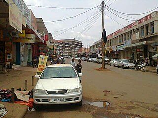
Masaka is a district and a city in the Buganda Region in southern Uganda, west of Lake Victoria. The city is the headquarters of Masaka District.

<span class="mw-page-title-main">Rakai</span> Place in Central Uganda, Uganda

Rakai is a town in the Central Region of Uganda. It is the site of the headquarters of Rakai District. Other towns in the district include Kalisizo, Kyotera Kakuuto and Mutukula.

<span class="mw-page-title-main">Kiruhura, Uganda</span> Place in Western Region, Uganda

Kiruhura is a town in the Western Region of Uganda. It is the largest town in Kiruhura District and the site of the district headquarters.

Kalisizo is a town in the southern part of the Central Region of Uganda. Although it is the leading commercial center in Kyotera District, the administrative headquarters of the district are in Kasaali.

Lukaya is a town in the Kalungu District of the Central Region of Uganda.

Kiwoko is a small town in the Central Region of Uganda. It is one of the municipalities in Nakaseke District.

Ngoma is a small town in Nakaseke District, Central Uganda. It is one of the municipalities within Nakaseke District. Other municipalities in the district include: (a) Butalangu (b) Kapeeka (c) Nakaseke (d) Semuto and (e) Wakyaato.

Mutukula is a town in Kyotera District, in the Central Region of Uganda, the third-largest economy in the East African Community. It sits adjacent to Mutukula, Tanzania, directly across the international border between Uganda and Tanzania.

Napak is a town in Northern Uganda. It is the commercial, administrative and municipal headquarters of Napak District. The district is named after the town.

Lwakhakha is a town in the Eastern Region of Uganda. It is one of the municipal centers in Manafwa District. The town lies across the international border from Lwakhakha, Kenya.

Rwekunye is a settlement in Kiryandongo District in the Western Region of Uganda.

Kazo is a town in the Western Region of Uganda. It is the capital of Kazo District.

Masaka–Mutukula Road is a road in the Central Region of Uganda, connecting the city of Masaka, in Masaka District, to the border town of Mutukula in Kyotera District.

Kalisizo General Hospital, also Kalisizo Hospital, is a hospital in the Central Region of Uganda.

<span class="mw-page-title-main">Kyotera District</span> District in Central Region, Uganda

Kyotera District is a district in the Central Region of Uganda. Kyotera is the largest town in the district but the district headquarters are located at Kasaali, a suburb of Kyotera.

Muhanga is a town in the Western Region of Uganda. It is the main commercial centre and largest town of Rukiga District. However, the district headquarters are located at Mparo.

Kibiito is a town in the Western Region of Uganda. It is the chief administrative center of Bunyangabu District, and the district headquarters are located there.

References

  1. 1 2 UBOS (November 2014). "National Population and Housing Census 2014: Provisional Results: Appendix 3 - Households and Population by Subcounty/ Town Council/Urban Division and Sex, 2014" (PDF). Kampala: Uganda Bureau of Statistics (UBOS). Archived from the original (PDF) on 10 January 2017. Retrieved 3 August 2017.
  2. 1 2 Bindhe, Edward (1 July 2017). "Kyotera District Starts Operations". Kampala: Uganda Radio Network . Retrieved 3 August 2017.
  3. GFC (14 July 2015). "Road Distance Between Masaka And Kyotera With Map". Globefeed.com (GFC). Retrieved 14 July 2015.
  4. GFC (14 July 2015). "Map Showing Rakai And Kyotera With Route Marker". Globefeed.com (GFC). Retrieved 14 July 2015.
  5. Google (14 July 2015). "Location of Kyotera At Google Maps" (Map). Google Maps . Google. Retrieved 14 July 2015.
  6. UBOS (2011). "Estimated Population of Kyotera In 2002, 2010 & 2011" (PDF). Uganda Bureau of Statistics (UBOS). Retrieved 14 July 2015.
  7. Google (3 August 2017). "Map Showing Masaka–Mutukula Road in Kyotera" (Map). Google Maps . Google. Retrieved 3 August 2017.
  8. MCC (3 August 2017). "Map Showing Kasaali, Kyotera District, Central Region, Uganda". Mapcarta.com (MCC). Retrieved 3 August 2017.

00°37′54″S31°32′36″E / 0.63167°S 31.54333°E / -0.63167; 31.54333