
Stephen Kalonzo Musyoka is a Kenyan politician who was the tenth Vice-President of Kenya from 2008 to 2013. Musyoka served in the government under the late President Daniel arap Moi as the Secretary of Kenya African National Union party (1980-1988), Assistant Minister for Works (1986-1988), Deputy Speaker of the National Assembly (1988-1992), Minister for Foreign Affairs from 1993 until 1998, Minister of Education (1998-2001); and subsequently, under the late President Mwai Kibaki, he was Minister of Foreign Affairs again from 2003 to 2004, then Minister of the Environment from 2004 to 2005. He was an unsuccessful candidate in the 2007 presidential election, after which he was appointed vice-president by Kibaki in January 2008.

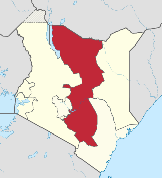
The Kamba or Akamba people are a Bantu ethnic group who predominantly live in the area of Kenya stretching from Nairobi to Tsavo and north to Embu, in the southern part of the former Eastern Province. This land is called Ukambani and constitutes Makueni County, Kitui County and Machakos County. They also form the second largest ethnic group in 8 counties including Nairobi and Mombasa counties.
The Eastern Province of Kenya was one of 8 Provinces of Kenya. Its northern boundary ran along with that of Ethiopia; the North Eastern Province and Coast Province lay to the east and south; and the remainder of Kenya's provinces, including Central Province, ran along its western border. The provincial capital was Embu.
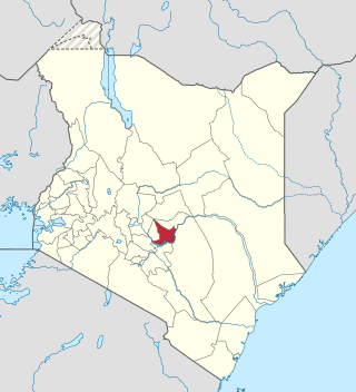
Kitui is a town and capital of Kitui County in Kenya, 185 kilometres east of Nairobi and 105 kilometres east of Machakos. it covers an area approximately 30,496.4 km squares and lies between latitudes 0°10 South and 3°0 South and longitudes 37°50 East and 39°0 East. It borders seven counties i.e. Machakos and Makueni counties to the west, Tana River County to the east and south-east, Taita Taveta County to the south, Embu to the north-west, and Tharaka-Nithi and Meru counties to the north. Kitui became the headquarters of Kitui County after the adoption of the new constitution and the devolved government.

Kisumu County is one of 47 counties in the Republic of Kenya. Its borders follow those of the original Kisumu District, one of the former administrative districts of the former Nyanza Province in western Kenya. Its headquarters is Kisumu City which is the third largest city in Kenya after the capital Nairobi and the coastal city of Mombasa. It has a population of 1,155,574. The land area of Kisumu County totals 2085.9 km2.

Tana River County is a county in the former Coast Province of Kenya. It is named after the Tana River, the longest river in Kenya. It has an area of 38,437 km2 (14,841 sq mi) and a population of 315,943 as of the 2019 census. The county borders Kitui County to the west, Garissa County to the northeast, Isiolo County to the north, Lamu County to the southeast and Kilifi County to the south.The administrative headquarters of the county is Hola also known as Galole. The County has five (5) sub Counties; Tana Delta, Tana River, Tana North, Galedyertu, and Bangal.
Embu County is a county of the Republic of Kenya. The capital of Embu County and the former Eastern province headquarters, Embu is a large and largely metropolitan area with a population of 608,599 persons. The county borders Kirinyaga to the west, Kitui to the east, Tharaka Nithi to the north and Machakos to the south. The county occupies an area of 2,821 km2.

Machakos County is one of the 47 counties of Kenya, which came into being because of the devolved system of governance occasioned by the 2010 constitution of Kenya. The country's first administrative headquarters are in Machakos Town, which is the largest town in the county. The county had a population of 1,421,932 as of 2019. The county borders Nairobi and Kiambu counties to the west, Embu to the north, Kitui to the east, Makueni to the south, Kajiado to the south west, and Muranga and Kirinyaga to the north west.
Mwingi District was a former district of Kenya, located in the now defunct Eastern Province. The district had a population of 303.828. Its capital was Mwingi town.

Local authorities in Kenya are the bodies controlling local governance in urban areas in Kenya.

Kitui County is a county in the former Eastern Province of Kenya with its capital and largest town being Kitui, although Mwingi is also another major urban centre. The county has a population of 1,136,187. and an area of 30,496 km2. It lies between latitudes 0°10 South and 3°0 South and longitudes 37°50 East and 39°0 East.
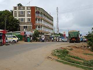
Mwingi is a town in Kitui County in the Eastern Region of the Republic of Kenya. It has an urban population of 15,970. The town is located along the A3 Road between Nairobi and Garissa, 47 kilometres (29 mi) north of its county capital Kitui, and 200 kilometres (120 mi) east of the capital city of Nairobi. It was the capital of the former Mwingi District.
The districts of Kenya were divided into 262 divisions (matarafa). Divisions of Kenya were further subdivided into locations. Today's counties of Kenya are based on the merging of some of the districts on this list and since the divisions are one level under the districts they are now the sub-counties. This is because Kenya recently changed its constitution and 47 Counties emerged. Here are the divisions listed below, by district :
The Roman Catholic Diocese of Kitui is a diocese located in the city of Kitui in the ecclesiastical province of Nairobi in Kenya.
South B is the name of a Division of the sub-county of Starehe in Nairobi, Kenya and the name of a "sub-location" of Mukuru Nyayo within the Division. The 2019 Kenya Census gives a population of 102,441 for South B Division and 34,216 for the sub-location. South B is about 3 kilometres (1.9 mi) south-east of Nairobi Central Business District; the Industrial Area lies to the east and the South C district to the south-west.
Kalitini is a location in Kitui County, Mwingi East Sub-county. It is found Mui basin a region classified as a coal-rich area. The inhabitants of this area are subsistence farmers who farm mainly food crops like;- Green grams, Cowpeas, peas, millet, sorghum, and sometimes maize. Lately, the residents have started farming watermelons which are doing fantastically very well and have earned the region a great deal of income. It is a region inhabited by very hardworking people as well as very well-educated and informed citizens of Kenya. Renowned professors, doctors, lawyers, engineers, and scientists in Kenya come from this area.Kenya's Eastern Province.
Sub-counties, also known as Districts, are the decentralised units through which government of Kenya provides functions and services. At national level, sub-counties take a more administrative function like security, statistical purposes, provision of government services, etc. Even though the sub-counties are divisions of counties, powers to create new national sub-counties lies with the national government. As of 2023, there are 314 sub-counties, compared to 290 constituencies. A deputy county commissioner is appointed by the state to lead each sub-county. The sub-counties are further divided into divisions, locations and sub-locations.
The Africa Evangelical Presbyterian Church (AEPC) is a growing conservative Presbyterian and Reformed Church which adheres to the Westminster Confession of Faith started in Kenya, later spread to the surrounding countries like Burundi, Tanzania, Congo and as far as Zimbabwe. The headquarters of the church is located in Nairobi, Kenya. The current Moderator is Rev. Dr Joseph Mutei installed on Sunday 26th June 2022.
Kitui District was an administrative district in the Eastern Province of Kenya. Its capital was Kitui. The district had an area of 20,402 km².
The Anglican dioceses of Mombasa are the Anglican presence in and around Mombasa and south-east Kenya; they are part of the Anglican Church of Kenya. The remaining dioceses of the Church are in the areas of Maseno, of Mount Kenya, and of Nakuru.
