| Königshütte Dam | |
|---|---|
 | |
| Location | Harz county |
| Coordinates | 51°44′19″N10°47′36″E / 51.73861°N 10.79333°E Coordinates: 51°44′19″N10°47′36″E / 51.73861°N 10.79333°E |
| Construction began | 1952 |
| Opening date | 1956 |
| Dam and spillways | |
| Height | 18.2 m |
| Length | 108 m |
| Width (crest) | 7 m |
| Dam volume | 13,500 m³ |
| Spillway capacity | 258.7 m³/s |
| Reservoir | |
| Total capacity | 1.45 million m³ |
| Catchment area | 154.2 km² |
| Surface area | 32 ha |
The Königshütte Dam (German : Talsperre Königshütte) is a dam in the German state of Saxony-Anhalt in the Harz mountains. It impounds the River Bode and lies between Königshütte and Susenburg (both in the borough of Oberharz am Brocken). It is a so-called storage reservoir (Überleitungssperre) forming part of the Rappbode Dam system.

German is a West Germanic language that is mainly spoken in Central Europe. It is the most widely spoken and official or co-official language in Germany, Austria, Switzerland, South Tyrol (Italy), the German-speaking Community of Belgium, and Liechtenstein. It is also one of the three official languages of Luxembourg and a co-official language in the Opole Voivodeship in Poland. The languages which are most similar to German are the other members of the West Germanic language branch: Afrikaans, Dutch, English, the Frisian languages, Low German/Low Saxon, Luxembourgish, and Yiddish. There are also strong similarities in vocabulary with Danish, Norwegian and Swedish, although those belong to the North Germanic group. German is the second most widely spoken Germanic language, after English.

A dam is a barrier that stops or restricts the flow of water or underground streams. Reservoirs created by dams not only suppress floods but also provide water for activities such as irrigation, human consumption, industrial use, aquaculture, and navigability. Hydropower is often used in conjunction with dams to generate electricity. A dam can also be used to collect water or for storage of water which can be evenly distributed between locations. Dams generally serve the primary purpose of retaining water, while other structures such as floodgates or levees are used to manage or prevent water flow into specific land regions. The earliest known dam is the Jawa Dam in Jordan, dating to 3,000 BC.

Saxony-Anhalt is a state of Germany.
Contents
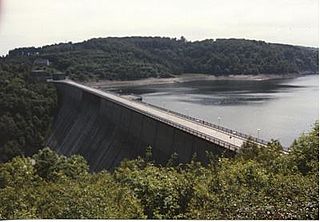
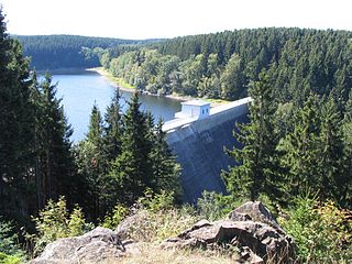
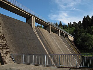
The dam itself was built on the Bode from 1939–1943 and 1952–1956 with construction being interrupted by the war. It is an 18 metre high gravity dam, made of concrete, for the supply of drinking water and for flood protection. It also provides reserves of water during times of drought and hydro-electric power. The power station has a nominal output of 60 kW and generates 0.18 GWh per annum.

A gravity dam is a dam constructed from concrete or stone masonry and designed to hold back water by primarily using the weight of the material alone to resist the horizontal pressure of water pushing against it. Gravity dams are designed so that each section of the dam is stable, independent of any other dam section.

Concrete, usually Portland cement concrete, is a composite material composed of fine and coarse aggregate bonded together with a fluid cement that hardens over time—most frequently a lime-based cement binder, such as Portland cement, but sometimes with other hydraulic cements, such as a calcium aluminate cement. It is distinguished from other, non-cementitious types of concrete all binding some form of aggregate together, including asphalt concrete with a bitumen binder, which is frequently used for road surfaces, and polymer concretes that use polymers as a binder.

Drinking water, also known as potable water, is water that is safe to drink or to use for food preparation. The amount of drinking water required varies. It depends on physical activity, age, health issues, and environmental conditions. Americans, on average, drink one litre of water a day and 95% drink less than three litres per day. For those who work in a hot climate, up to 16 litres a day may be required. Water is essential for life.
The gently curving dam wall is 108 m long and has a volume of 13,500 m³. It can be overtopped along almost its entire length. In one section there is a fish-belly flap gate that can be lowered by 1.5 metres to provide flood control.

Flood control methods are used to reduce or prevent the detrimental effects of flood waters. Flood relief methods are used to reduce the effects of flood waters or high water levels.
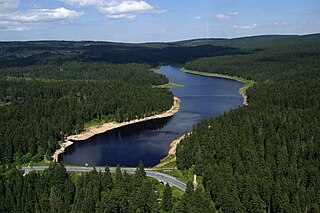
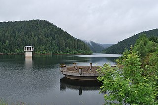
The reservoir has a capacity of 1.2 million m³ and covers an area of 32 hectares. Part of the water is diverted from here through a 1,795 m long tunnel to the Rappbode Reservoir. The rest flows back into the Bode and down to the Wendefurth Reservoir, where it is reunited with the water from the Rappbode Reservoir again.

A reservoir is, most commonly, an enlarged natural or artificial lake, pond or impoundment created using a dam or lock to store water.
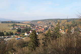
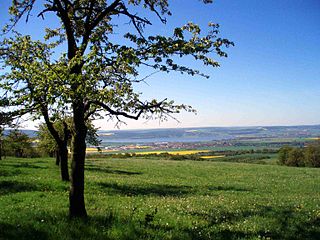
A quiet concrete road from Königshütte runs along the northern side of the reservoir as far as the dam. On the south side a wide footpath leads back to Königshütte, which passes the confluence of the Kalte and Warme Bode. Numerous footpaths lead from the dam in almost all directions of the compass. The location is suitable for both anglers and walkers.

In geography, a confluence occurs where two or more flowing bodies of water join together to form a single channel. A confluence can occur in several configurations: at the point where a tributary joins a larger river ; or where two streams meet to become the source of a river of a new name ; or where two separated channels of a river rejoin at the downstream end.

A fisherman or fisher is someone who captures fish and other animals from a body of water, or gathers shellfish.

A pedestrian is a person travelling on foot, whether walking or running. In some communities, those travelling using tiny wheels such as roller skates, skateboards, and scooters, as well as wheelchair users are also included as pedestrians. In modern times, the term usually refers to someone walking on a road or pavement, but this was not the case historically.
 Western section
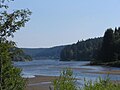 Approach from Königshütte
 North side
 East side of the dam