
Bodø is a municipality in Nordland county, Norway. It is part of the traditional region of Salten. The administrative centre of the municipality is the town of Bodø. Some of the notable villages in Bodø include Misvær, Skjerstad, Saltstraumen, Løding, Løpsmarka, Kjerringøy, Sørvær, and Fenes.

Leknes (help·info) is a town in Nordland county, Norway. The town is also the administrative centre of the municipality of Vestvågøy. Leknes was designated a "town" in 2002. The 2.52-square-kilometre (620-acre) town has a population (2018) of 3,556 which gives the town a population density of 1,411 inhabitants per square kilometre (3,650/sq mi).

Misvær is a village in Bodø Municipality in Nordland county, Norway. It is located at the end of the Misværfjorden, about 40 kilometres (25 mi) southeast of the town of Bodø in the Skjerstad district of Bodø. The 0.48-square-kilometre (120-acre) village has a population (2011) of 245. The population density is 510 inhabitants per square kilometre (1,300/sq mi).

Ørnes is the administrative centre of the municipality of Meløy in Nordland county, Norway. The old village is mentioned in documents dating from 1610 when a tenant farmer lived here. It is located along Norwegian County Road 17, about 6 kilometres (3.7 mi) south of the village of Reipå and about 5 kilometres (3.1 mi) north of the village of Eidbukta. The island of Mesøya lies just west of the village. Ørnes is a port of call along the Hurtigruten ferry route between Nesna and Bodø. The newspapers Framtia and Meløyavisa are published in Ørnes.

Løding is a village in the municipality of Bodø in Nordland county, Norway. It is located about 17 kilometres (11 mi) east of the town of Bodø, and is connected to the town by the Tverlandet Bridge. The village is mostly referred to as Tverlandet, which also encompasses the areas Hopen, Vatne, Heggmoen, Mjønes, Vågan, Holand, Skålbunes, Elstad, Oddan, Allmenningen, Godøynes (Gaunes), and Naurstad, all of which lies around the village.

Bodin is a parish and former municipality in Nordland county, Norway. The 672-square-kilometre (259 sq mi) municipality existed from 1838 until its dissolution in 1968. It was a large municipality encompassing all of the mainland area around the town of Bodø and part of the land on the southern shore of the Saltfjorden. The municipality also included over 100 square kilometres (39 sq mi) of islands, notably the islands of Helligvær, Landegode, Bliksvær, and Givær plus numerous others. In all there were over 700 islands, islets, and skerries in Bodin Municipality. All of what was Bodin Municipality now lies entirely inside the present-day Bodø Municipality.

Fjærvatnet or Indre Fjærvatn is a lake that lies in the municipality of Bodø in Nordland county, Norway. The 2.48-square-kilometre (0.96 sq mi) lake is located about 3 kilometres (1.9 mi) south of the village of Kjerringøy, near the village of Fjære.
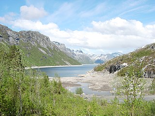
Gjømmervatnet is a lake that lies in the municipality of Bodø in Nordland county, Norway. The 6.66-square-kilometre (2.57 sq mi) lake lies about 7 kilometres (4.3 mi) southwest of the village of Misvær in the Skjerstad area of Bodø. The lake is regulated for use for the Oldereid Hydroelectric Power Station, northwest of Misvær.
Heggmovatnet is a lake that lies in the municipality of Bodø in Nordland county, Norway. The 9.38-square-kilometre (3.62 sq mi) lake is located about 10 kilometres (6.2 mi) northeast of the village of Løding. The lake is regulated and it is the main water source for the town of Bodø. The water flows out of the lake into the river Heggmoelva, which then flows into the lake Vatnvatnet. Sjunkhatten National Park surrounds the lake.
Soløyvatnet is a lake that lies in the municipality of Bodø in Nordland county, Norway. The 4.85-square-kilometre (1.87 sq mi) lake is located about 5 kilometres (3.1 mi) northeast of the town of Bodø.
Valnesvatnet is a lake that lies in the municipality of Bodø in Nordland county, Norway. The 4.91-square-kilometre (1.90 sq mi) lake lies along the Norwegian County Road 17 about 1 kilometre (0.62 mi) north of the border with Gildeskål Municipality, just northeast of the village of Nygårdsjøen. The water in the lake flows out over the Valnesfossen waterfall on its way to the sea.

Vatnvatnet is a lake that lies in the municipality of Bodø in Nordland county, Norway. The 4.71-square-kilometre (1.82 sq mi) lake lies about 2 kilometres (1.2 mi) north of the village of Løding and just south of the Sjunkhatten National Park. The lake Heggmovatnet flows out into this lake.

Folden is a former municipality in Nordland county, Norway. The 2,271-square-kilometre (877 sq mi) municipality existed from 1838 until its dissolution in 1887. Folden encompassed all of the areas surrounding the Folda fjord and all of the fjord branches that connect to the main fjord. It included all the areas in what is now Sørfold Municipality, plus the Kjerringøy area of Bodø Municipality, and the southeastern part of the Steigen Municipality.

Straumsnes or Strømsnes is a village in the municipality of Fauske in Nordland county, Norway. It is located in the Valnesfjord area of Fauske. The town of Fauske lies 15 kilometres (9.3 mi) to the east and the town of Bodø lies about 40 kilometres (25 mi) to the west. The village sits just inland of Skjerstad Fjord, along the southern shore of the lake Valnesfjordvatnet.

Sørland is a fishing village and the administrative centre of Værøy Municipality in Nordland county, Norway. It is located on the southern side of the island of Værøya. The village is the main population center of the island, and it is the location of Værøy Church, Værøy Heliport, and Værøy Lighthouse. The village of Nordland lies about 5 kilometres (3.1 mi) to the north and the now-abandoned village of Mostad is located about 5 kilometres (3.1 mi) to the southwest. There are no other villages on the island.

Drag (Norwegian) or Ájluokta (Lule Sami) or Áiluokta (Northern Sami) is a village in the municipality of Tysfjord in Nordland county, Norway. It is located along the Tysfjorden, about 180 kilometres (110 mi) northeast of the town of Bodø and about 110 kilometres (68 mi) south of the town of Narvik. The 0.44-square-kilometre (110-acre) village has a population (2018) of 319 which gives the village a population density of 725 inhabitants per square kilometre (1,880/sq mi).

Bodø or Bådåddjo (Lule Sami) is a town in Bodø Municipality in Nordland county, Norway. The town the administrative centre of Bodø Municipality and of Nordland county. It is located on the Bodø peninsula between the Vestfjorden and the Saltfjorden. Bodø is located just north of the Arctic Circle. It is the largest urban area and town in Nordland county and it is the second-largest town in North Norway.

Skjerstad is a former municipality in Nordland county, Norway. The 465-square-kilometre (180 sq mi) municipality existed from 1838 until its dissolution in 2005. The municipality generally encompassed the area around the Misværfjorden in what is now Bodø Municipality, although it originally was much larger, also including the entire present-day Fauske Municipality. The administrative centre of Skjerstad municipality was the village of Misvær.

Kjerringøy is a former municipality in Nordland county, Norway. The 176-square-kilometre (68 sq mi) municipality existed from 1906 until its dissolution in 1964. The municipality included the coastal and island areas around the entrance to the Folda fjord, plus the northern coast of the Mistfjorden to the south of the Folda fjord. About 400 small islands totaling about 11 square kilometres (4.2 sq mi) were part of the municipality. The areas are located in what is now Bodø Municipality and a small part in Steigen Municipality. The administrative centre of the municipality was the village of Kjerringøy where Kjerringøy Church is located.

Røstlandet is the administrative centre of Røst Municipality in Nordland county, Norway. The fishing village covers the southeastern half of the island of Røstlandet. Røst Airport is located on the northern part of the island. Røst Church is located in the village and serves the people of Røst Municipality.


