LOCOPROL

Last updated

LOCOPROL (Low Cost satellite based train location system for signalling and train Protection for Low density traffic railway lines) has been a project to research the integration of satellite navigation into railway networks targeting low-density track lines. It is supposed to extend the ERTMS train protection systems. The partner project LOCOLOC was looking into cab signaling and speed control measures.

Locoprol has its technical foundation in systems like Euteltrac / OmniTRACS from Qualcomm in use since 1991 for satellite-based fleet management [1] followed by APOLO (Advanced Position Locator), ECORAIL (EGNOS Controlled Railway Equipment) and the parallel INTEGRAIL project (2001–2003) [2] der ESA [3] The LOCOPROL project was funded by the 5. Framework Programme of the EU [3] just like the GADEROS project (GAlileo DEmonstrator Railway Operation System) [4] starting at the same to research the integration of satellite navigation into the ERTMS standard (project partners were INECO, TIFSA, Railways Safety, ERRI, Aena, GMV Sistemas, Sener, NSL). [1] The project was coordinated by Alstom. [5]

The LOCOPROL project partners were Alstom (Belgium), Honeywell Regelsysteme Gmbh (Germany), INRETS (France), Alstom Transport (Italy), Trasys (Belgium), Alstom Transport (France), BPV (Germany), Septentrio (Belgium), Reseau Ferré de France (France), Société Nationale des Chemins de fer Belges (Belgium), Northern Jiaotong University (China), European Road Transport Telematics Implementation Coordination Organisation S.C.R.L. (Belgium).

The project did officially end in 2005 however it was continued in other projects building on its results. The ESA started in 2006 the project RUNE (Railway User Navigation Equipment) [6] to use Galileo (satellite system) to create "virtual balises" [3] and the projekt GEORAIL at the UIC continues to research satellite navigation in rail transport since 2004. [3] the 6. Framework Programme of the EU contains GIRASOLE (accompanied by GPS-LOC of the SCNF), GRAIL and M-TRADE which ran until 2007. [3] In England LOCASYS project was started continuing the LOCOPROL project with a target on dependability until 2009. [3] In Belgium the LOCOPROL pilot railway track was extended in the TransLogisTIC project between 2007 and 2009 looking into integration of railway and classic fleet management. [3] The actual usage of satellite navigation in railway systems can be currently found[ clarification needed ] systems like the Tr@in-MD of SCNF for dangerous goods wagons traceability and Gédéon of SCNF for tracking of freight. [3]

Similar projects covering train protection systems can be found in the Nationwide Differential Global Positioning System (NDGPS) to be deployed as a satellite-based protection system in the Positive Train Control from 2015 in the USA. The ERTMS Regional system of Banverket is also a low-cost variant of ERTMS but it is not based satellite navigation so far. The GSA/ESA has proposed the GRAIL-2 project for the 7. Framework Programme to continue the research of integration of satellite navigation into ERTMS. [7] Research did continue in other projects including GaLoROI and 3inSat. [8] The eight Framework Programme alias Horizon 2020 funds more projects on satellite based localization in railway operations. [9] This includes RHINOS [10] and STARS. [11]

The results of the LOCOLOC/LOCOPROL project [12] have shown that satellite navigation in urban areas is highly restricted by satellites in range. The project has developed algorithms to map satellite signals to a 1D flat track map that allows to check the position even with only two satellites in range (from 6 satellites required for a safe EGNOS measurement it allows 3 failures and in some cases 4 failures). [12] Still the results have not been able to meet SIL4 safety of life boundaries (with 98% of measures successful outside tunnels) [12] however the test model had not been conclusive regarding dependability on all system conditions. [13] The results indicate so far that passive (fixed data) balises are necessary in the vicinity of railway stations to counter the lack of accuracy of the satellite train positioning. [13]

As EGNOS certification for safety of life applications will be achieved in 2010 the LOCOPROL results may be re-evaluated with the system running in a non-prototype environment. In comparison, the North American Joint Positive Train Control system is testing with two Differential GPS receivers combined with an inertial navigation system for dead reckoning in areas with not enough satellites in sight. [14] The Italian Ansaldo STS has developed a train control system based Russian entwickelte KLUB-U safety systems - the ITARUS-ATC takes advantage of satellite navigation in combination with an inertial navigation system and wheel sensors to measure the travel distance reaching a safety level ready for passenger transport in Russia - it will be deployed on the track to Sotchi up to the winter games 2014. [15]

Related Research Articles

<span class="mw-page-title-main">Galileo (satellite navigation)</span> European global navigation satellite system

Galileo is a global navigation satellite system (GNSS) that went live in 2016, created by the European Union through the European Space Agency (ESA), operated by the European Union Agency for the Space Programme (EUSPA), headquartered in Prague, Czechia, with two ground operations centres in Oberpfaffenhofen, Germany, mostly responsible for the control of the satellites, and in Fucino, Italy, mostly responsible for providing the navigation data. The €10 billion project is named after the Italian astronomer Galileo Galilei.

<span class="mw-page-title-main">European Geostationary Navigation Overlay Service</span> System that enhances the accuracy of GPS receivers

The European Geostationary Navigation Overlay Service (EGNOS) is a satellite-based augmentation system (SBAS) developed by the European Space Agency and EUROCONTROL on behalf of the European Commission. Currently, it supplements Galileo and GPS by reporting on the reliability and accuracy of their positioning data and sending out corrections. The system is intended to supplement Galileo in a future version.

<span class="mw-page-title-main">BeiDou</span> Chinese satellite navigation system

The BeiDou Navigation Satellite System is a satellite-based radio navigation system owned and operated by the China National Space Administration. It provides geolocation and time information to a BDS receiver anywhere on or near the Earth where there is an unobstructed line of sight to four or more BDS satellites. It does not require the user to transmit any data, and operates independently of any telephonic or Internet reception, though these technologies can enhance the usefulness of the BDS positioning information.

<span class="mw-page-title-main">Balise</span> Beacon or transponder used on railways

A balise is an electronic beacon or transponder placed between the rails of a railway as part of an automatic train protection (ATP) system. The French word balise is used to distinguish these beacons from other kinds of beacons.

<span class="mw-page-title-main">Satellite navigation</span> Use of satellite signals for geo-spatial positioning

A satellite navigation or satnav system is a system that uses satellites to provide autonomous geopositioning. A satellite navigation system with global coverage is termed global navigation satellite system (GNSS). As of 2024, four global systems are operational: the United States's Global Positioning System (GPS), Russia's Global Navigation Satellite System (GLONASS), China's BeiDou Navigation Satellite System (BDS), and the European Union's Galileo.

<span class="mw-page-title-main">European Train Control System</span> Railway signaling system

The European Train Control System (ETCS) is a train protection system designed to replace the many incompatible systems used by European railways, and railways outside of Europe. ETCS is the signalling and control component of the European Rail Traffic Management System (ERTMS).

<span class="mw-page-title-main">Real-time kinematic positioning</span> Satellite navigation technique used to enhance the precision of position data

Real-time kinematic positioning (RTK) is the application of surveying to correct for common errors in current satellite navigation (GNSS) systems. It uses measurements of the phase of the signal's carrier wave in addition to the information content of the signal and relies on a single reference station or interpolated virtual station to provide real-time corrections, providing up to centimetre-level accuracy. With reference to GPS in particular, the system is commonly referred to as carrier-phase enhancement, or CPGPS. It has applications in land surveying, hydrographic surveying, and in unmanned aerial vehicle navigation.

GIOVE, or Galileo In-Orbit Validation Element, is the name for two satellites built for the European Space Agency (ESA) to test technology in orbit for the Galileo positioning system.

<span class="mw-page-title-main">Quasi-Zenith Satellite System</span> Navigation satellites

The Quasi-Zenith Satellite System (QZSS), also known as Michibiki (みちびき), is a four-satellite regional satellite navigation system and a satellite-based augmentation system developed by the Japanese government to enhance the United States-operated Global Positioning System (GPS) in the Asia-Oceania regions, with a focus on Japan. The goal of QZSS is to provide highly precise and stable positioning services in the Asia-Oceania region, compatible with GPS. Four-satellite QZSS services were available on a trial basis as of 12 January 2018, and officially started on 1 November 2018. A satellite navigation system independent of GPS is planned for 2023 with seven satellites. In May 2023 it was announced that the system would expand to eleven satellites.

The GPS-aided GEO augmented navigation (GAGAN) is an implementation of a regional satellite-based augmentation system (SBAS) by the Government of India. It is a system to improve the accuracy of a GNSS receiver by providing reference signals. The Airports Authority of India (AAI)'s efforts towards implementation of operational SBAS can be viewed as the first step towards introduction of modern communication, navigation and surveillance / air traffic management system over the Indian airspace.

The European Rail Traffic Management System (ERTMS) is the system of standards for management and interoperation of signalling for railways by the European Union (EU). It is conducted by the European Union Agency for Railways (ERA) and is the organisational umbrella for the separately managed parts of

The European Union Space Programme is an EU funding programme established in 2021 along with its managing agency, the European Union Agency for the Space Programme, in order to implement the pre-existing European Space Policy established on 22 May 2007 when a joint and concomitant meeting at the ministerial level of the Council of the European Union and the Council of the European Space Agency, known collectively as the European Space Council, adopted a Resolution on the European Space Policy. The policy had been jointly drafted by the European Commission and the Director General of the European Space Agency. This was the first common political framework for space activities established by the European Union (EU).
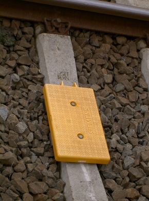
Transmission balise-locomotive is a train protection system used in Belgium and on Hong Kong's East Rail line.

In the field of geodesy, Receiver Independent Exchange Format (RINEX) is a data interchange format for raw satellite navigation system data. This allows the user to post-process the received data to produce a more accurate result — usually with other data unknown to the original receiver, such as better models of the atmospheric conditions at time of measurement.

A software GNSS receiver is a Global Navigation Satellite System (GNSS) receiver that has been designed and implemented using software-defined radio.

The European Satellite Navigation Competition (ESNC) is an annual international innovation competition that recognises downstream applications of satellite navigation. Anyone is free to enter. The ESNC was inaugurated in three regions in 2004 under the patronage of the Bavarian Ministry of Economic Affairs and is organised by Anwendungszentrum GmbH Oberpfaffenhofen (AZO). Since 2011, the competition is also supported by the European Commission. Until 2006, the ESNC was called “Galileo Masters" in reference to the European satellite navigation system Galileo.

Inside GNSS (IG) is an international controlled circulation trade magazine and website owned by Gibbons Media and Research LLC. It covers space-based positioning, navigation and timing (PNT) technology for engineers, designers, and policy-makers of global navigation satellite systems (GNSS). In the United States, GNSS is identified mainly with the government-operated Navstar Global Positioning System (GPS). InsideGNSS.com is the complimentary website of online news, events, digital newsletters, and webinars, and archived magazine articles.

<span class="mw-page-title-main">European Union Agency for the Space Programme</span> Agency of the European Union

The European Union Agency for the Space Programme (EUSPA) is a space agency, managing the European Union Space Programme as one of the agencies of the European Union (EU). It was initially created as the European Global Navigation Satellite Systems Supervisory Authority (GSA) in 2004, reorganised into the European Global Navigation Satellite Systems Agency in 2010, and established in its current form on May 12, 2021. EUSPA is a separate entity from the European Space Agency (ESA), although the two entities work together closely.

Washington Yotto Ochieng is a Kenyan-born British academic who is Head of the Department of Civil and Environmental Engineering at Imperial College London. Previously, he was Head of the Centre for Transport Studies and Co-Director of the Institute for Security Science and Technology(ISST) together with Deeph Chana. Ochieng is a Senior Security Science Fellow in ISST. He also serves as Director of the Engineering Geomatics Group and Chair of Positioning and Navigation Systems.

<span class="mw-page-title-main">Directorate-General for Defence Industry and Space</span> Directorate-General of the European Commission

The Directorate-General for Defence Industry and Space is a department of the European Commission.

References

  1. 1 2 acroread "Fail-safe, Innovative, Cost-effective, Satellite based Train protection, control and command LOCOPROL" (PDF). Archived from the original (PDF) on 2007-01-01. Retrieved 2010-09-12.
  2. "INTEGRAIL - GNSS-1 Rail User Navigation Equipment". Esa.int. 2006-02-08. Retrieved 2012-05-22.
  3. 1 2 3 4 5 6 7 8 "GNSS and integrity positioning for railway applications" (PDF). ion-ch.ch. Archived (PDF) from the original on 25 May 2022. Retrieved 7 January 2023.
  4. "GADEROS Project Overview" (PDF). galileo.uic.asso.fr. Archived from the original (PDF) on November 26, 2006.
  5. "LOCOPROL : Low Cost satellite based train location system for signalling and train PROtection for Low density railway lines", Information and Communication Technologies, European Commission
  6. Railway User Navigation Equipment (RUNE), ESA homepage
  7. GRAIL-2: GNSS-based Enhanced Odometry for Rail Archived 2010-05-29 at the Wayback Machine , GNSS Supervisory Authority (GSA)
  8. Marais, Juliette; Beugin, Julie; Berbineau, Marion (2018-10-11). "A survey of GNSS-based Research and Developments for the European railway signaling". IEEE.
  9. "H2020 Projects". 18 May 2015.
  10. "DLR - Institut für Kommunikation und Navigation - RHINOS - Railway High Integrity Navigation Overlay System". Archived from the original on 2019-04-22. Retrieved 2019-04-22.
  11. "Home". stars-rail.eu.
  12. 1 2 3 LOCOLOC - Final Presentation, Noordwijk, December 2004
  13. 1 2 LOCOLPROL - System Safety Report Archived 2009-12-22 at the Wayback Machine , "The safety objective of 10−9/h for the LOCOPROL signalling system could only be accepted when the set of proof will take into account all the involved parameters, including common failures modes and degraded situation management, and the assessment of the dependability of the whole system.", "Therefore a full compliancy to the railway safety CENELEC standards and best practices in the railway field is clearly not achievable to this research project.", "The signalling also validated the fact the use of, at least, passive eurobalises is necessary to mitigate the risk during train position initialisation but also at singular location as points or in the vicinity of a railway station to counter the lack of accuracy of the satellite train positioning."
  14. "Satellite-Based Positioning for CBTC" Archived 2011-07-18 at the Wayback Machine , University of Pardubice, Czech Republic, 7–8 July 2005
  15. "Инновационное развитие технологии управления перевозочным процессом - Транспортная газета ЕВРАЗИЯ ВЕСТИ". Eav.ru. Retrieved 2012-05-22.