
Tacoma is a mid-sized urban port city and the county seat of Pierce County, Washington, United States. The city is on Washington's Puget Sound, 32 miles (51 km) southwest of Seattle, 31 miles (50 km) northeast of the state capital, Olympia, and 58 miles (93 km) northwest of Mount Rainier National Park. The population was 219,346, according to the 2020 census. Tacoma is the second-largest city in the Puget Sound area and the third-largest in the state. Tacoma also serves as the center of business activity for the South Sound region, which has a population of about 1 million.

The Cowlitz River is a river in the state of Washington in the United States, a tributary of the Columbia River. Its tributaries drain a large region including the slopes of Mount Rainier, Mount Adams, and Mount St. Helens.

The Nisqually River is a river in west central Washington in the United States, approximately 81 miles (130 km) long. It drains part of the Cascade Range southeast of Tacoma, including the southern slope of Mount Rainier, and empties into the southern end of Puget Sound. Its outlet was designated in 1971 as the Nisqually Delta National Natural Landmark.
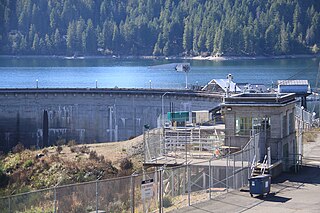
Cushman Dam No. 1 is a hydroelectric dam on the North Fork of the Skokomish River in Mason County, Washington, which in derogation of the natural and treaty rights of the Native inhabitants impounded and enlarged the formerly natural Lake Cushman, leading to damage claims in excess of $5 billion and an eventual settlement agreement with the Skokomish tribe that terminates the right to operate the dam(s) after 2048. It was built by Tacoma City Light in 1924–1926. Tacoma's demand for electricity grew rapidly after World War I. Tacoma City Light's Nisqually River Hydroelectric Project, built in 1912, could not meet the demand and the utility decided to build a new hydroelectric project on the North Fork Skokomish River. The dam and powerhouse first began to deliver electricity on February 12, 1926.

Cushman Dam No. 2 is a hydroelectric dam on the North Fork of the Skokomish River in Mason County, Washington, United States, forming Lake Kokanee. Built in 1930, its three 27,000 kilowatt generators provide 233 million kilowatt-hours annually to the Tacoma Power system. Along with Cushman Dam No. 1, it is part of Tacoma Power's Cushman Project.

Tacoma Power is a public utility providing electrical power to Tacoma, Washington and the surrounding areas. Tacoma Power serves the cities of Tacoma, University Place, Fircrest, and Fife, and also provides service to parts of Steilacoom, Lakewood, and unincorporated Pierce County. It is a division of the Tacoma Public Utilities and owns the Click! Network, developed by Steven Klein, Tacoma Power's former superintendent.

Lake Chelan Dam officially known as the Lake Chelan Hydroelectric Project is located approximately 32 miles (51 km) north of the city of Wenatchee in Chelan County, near the geographic center of Washington state. The dam is located at the lower or southeasterly end of 50.4 miles long Lake Chelan, and is within the limits of the city of Chelan. The powerhouse is located near the community of Chelan Falls. The reservoir has 677,400 acre-feet (835,600,000 m3) of usable water storage. The 10-year average generation for the Project is 365,000 megawatt hours.

The Conowingo Dam is a large hydroelectric dam in the lower Susquehanna River near the town of Conowingo, Maryland. The medium-height, masonry gravity dam is one of the largest non-federal hydroelectric dams in the U.S., and the largest dam in the state of Maryland.

Douglas Dam is a hydroelectric dam on the French Broad River in Sevier County, Tennessee, in the southeastern United States. The dam is operated by the Tennessee Valley Authority (TVA), which built the dam in record time in the early 1940s to meet emergency energy demands at the height of World War II. Douglas Dam is a straight reinforced concrete gravity-type dam 1705 feet long and 202 feet high, impounding the 28,420-acre (11,500 ha) Douglas Lake. The dam was named for Douglas Bluff, a cliff overlooking the dam site prior to construction.
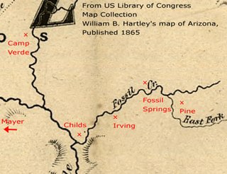
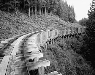
Childs-Irving Hydroelectric Facilities consisted of two 20th-century power plants, a dam, and related infrastructure along or near Fossil Creek in the U.S. state of Arizona. The complex was named an Historic Mechanical Engineering Landmark in 1971 and was added to the National Register of Historic Places 20 years later. Decommissioned in 2005, the plants no longer produce electricity, and much of the infrastructure—including the dam, the Irving Power Plant, and thousands of feet of concrete flumes—have been removed, and the creek's original flow has been restored.
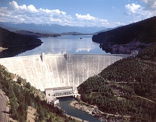
Hungry Horse Dam is an arch dam in the western United States, on the South Fork Flathead River in the Rocky Mountains of northwest Montana. It is located in Flathead National Forest in Flathead County, about fifteen miles (24 km) south of the west entrance to Glacier National Park, nine miles (14 km) southeast of Columbia Falls, and twenty miles (32 km) northeast of Kalispell. The Hungry Horse project, dam, and powerplant are operated by the U.S. Bureau of Reclamation. The entrance road leading to the dam is located in Hungry Horse.

Mossyrock Dam is a concrete arch-gravity dam on the Cowlitz River near Mossyrock in Lewis County, Washington. The reservoir created by the dam is called Riffe Lake and the primary purpose of the dam is hydroelectric production while flood control is secondary. The dam is the tallest in Washington State and its hydroelectric power station supplies 40% of Tacoma Power's electricity.

Alder Dam is a concrete thick arch dam on the Nisqually River in the U.S. state of Washington. The construction began in 1942 and was completed in 1945. At this time Alder Dam was among the tallest dams in the United States, although this title has since been surpassed. The impounded water behind the dam forms Alder Lake, stretching about 7 miles (11 km) upstream with a capacity of 241,950 acre-feet (0.29844 km3). With 28 miles (45 km) of shoreline, the lake is a popular recreation spot close to Mount Rainier National Park.

The Rio Grande Project is a United States Bureau of Reclamation irrigation, hydroelectricity, flood control, and interbasin water transfer project serving the upper Rio Grande basin in the southwestern United States. The project irrigates 193,000 acres (780 km2) along the river in the states of New Mexico and Texas. Approximately 60 percent of this land is in New Mexico. Some water is also allotted to Mexico to irrigate some 25,000 acres (100 km2) on the south side of the river. The project was authorized in 1905, but its final features were not implemented until the early 1950s.

Alder Lake is a 7 mi (11 km) long reservoir on the Nisqually River in Eatonville, Washington in the U.S. state of Washington, which was created by the construction of Alder Dam by Tacoma Power in September 1944. At the very eastern end of the lake is the town of Elbe, Washington. The name of the lake recalls the former small town of Alder, which was flooded in 1945 by the impounded water of the lake and disappeared. The extinct town, in turn, was named for alder trees near the original site.

Amistad Dam is a major embankment dam across the Rio Grande between Texas, United States, and Coahuila, Mexico. Built to provide irrigation water storage, flood control, and hydropower generation, it is the largest dam along the international boundary reach of the Rio Grande. The dam is over 6 miles (9.7 km) long, lies mostly on the Mexican side of the border, and forms Amistad Reservoir. It supplies water for irrigation in the Rio Grande Valley, 574 miles (924 km) upstream of the Rio Grande's mouth on the Gulf of Mexico at Brownsville, Texas/Matamoros, Tamaulipas.

Abiquiu Dam is a dam on the Rio Chama, located about 60 miles (97 km) northwest of Santa Fe in Rio Arriba County, New Mexico. Built and operated by the U.S. Army Corps of Engineers (USACE), the dam is an earth embankment structure 354 feet (108 m) high and 1,800 feet (550 m) long, containing 11.8 million cubic yards of fill. The dam forms Abiquiu Lake, one of the largest lakes in New Mexico with a full storage capacity of 1,369,000 acre-feet (1,689,000 dam3) and 5,200 acres (2,100 ha) of water. To date, the reservoir has never filled to capacity, with a record high of 402,258 acre-feet (496,178 dam3), 29.4% of full pool, on June 22, 1987. The dam's primary purpose is flood control, in addition to irrigation and municipal water storage, and hydroelectric generation.
The Electron Hydroelectric Project, originally known as the Puyallup Project, is a hydroelectric power plant operated by Electron Hydro LLC on the Puyallup River in Pierce County, Washington. It generates 22 megawatts (30,000 hp) of electricity and is operated and maintained by approximately 20 full-time employees.

Electricity in the Puget Sound region is a significant factor in people's lives, an enabler for the modern economy, and has a unique relationship with the region's environment.
