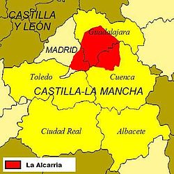
La Alcarria

Last updated
La Alcarria
Natural region
Landscape one.jpg
Landscape in La Alcarria
La Alcarria.jpg
Map of the region
Country Spain
Elevation
750 m (2,460 ft)

The Alcarria (Spanish : La Alcarria) is a natural region in Castile (Spain). It is located mainly in Guadalajara Province but also overlaps those of Cuenca and Madrid. Its principal attractions are its fauna and flora and it is noted for its honey, olives, and a special breed of lamb.

Contents

The most notable towns in the region are: Almonacid de Zorita, Brihuega, Cifuentes, Nuevo Baztán, Huete, Guadalajara, Chinchón, Arganda del Rey, Illana, Priego, Jadraque, Cañaveras, Loeches, Campo Real, Mondéjar, Pastrana, Sacedón, Trillo and Villalba del Rey. [ citation needed ]

The region figures prominently in the travel book Viaje a la Alcarria (Journey to the Alcarria) by Camilo José Cela. [1]

Geography

La Alcarria is a kind of plateau brought out by the rising of the Sistema Ibérico. The strata that form this plateau are smoothly undulating. Limestones and gypsum are common because of its origins below the sea surface (from the Mesozoic Era); the red sandstone and the earth-originated conglomerated stones were more recently formed. Over this strata of sedimentary stones, the rivers have originated deep and quite often, broad valleys, gorges and many other karst phenomena, as those that can be seen in the north of the Province of Cuenca (Las Majadas, El Hosquillo, La Ciudad Encantada, Ravines of the rivers Beteta and Júcar and in almost the whole Province of Guadalajara (Canyon of River Dulce, high course of River Tagus, Ravine of River Corduentes and below the waters of the reservoir of Entrepeñas, also in the River Tagus). Is precisely, the name of Entrepeñas (among rocks) the one that represents the character of all the area, since River Tagus forms there a beautiful canyon close to Sacedón, where that dam is. [ citation needed ]

The upper level of the plateau of La Alcarria is quite uniform as can be seen in the photo, although it descends softly from north to south. In this image you can also see the sudden valley to the right (to the South of Escamilla) made by the valley of the River Guadiela.

See also

Related Research Articles

<span class="mw-page-title-main">Tagus</span> Longest river on the Iberian Peninsula

The Tagus is the longest river in the Iberian Peninsula. The river rises in the Montes Universales near Teruel, in mid-eastern Spain, flows 1,007 km (626 mi), generally westward with two main south-west sections, and empties into the Atlantic Ocean in Lisbon. Its drainage basin covers 80,100 km2 (30,927 sq mi) – exceeded in the peninsula only by the Douro. Several dams and diversions supply drinking water to population centers of central Spain and Portugal, and dozens of hydroelectric stations produce power. Between dams it follows a very constricted course, but after Almourol, Portugal, it expands into a wide alluvial valley, with a floodplain. It culminates in a large estuary at the Port of Lisbon in the capital city of Portugal.

<span class="mw-page-title-main">Community of Madrid</span> Autonomous community of Spain

The Community of Madrid is one of the seventeen autonomous communities of Spain. It is located in the centre of the Iberian Peninsula, and of the Central Plateau. Its capital and largest municipality is the City of Madrid, which is also the capital of the country. The Community of Madrid is bounded to the south and east by Castilla–La Mancha and to the north and west by Castile and León. It was formally created in 1983, based on the limits of the province of Madrid, which was until then conventionally included in the historical region of New Castile.

<span class="mw-page-title-main">Castilla–La Mancha</span> Autonomous community of Spain

Castilla–La Mancha is an autonomous community of Spain. Comprising the provinces of Albacete, Ciudad Real, Cuenca, Guadalajara and Toledo, it was created in 1982. It takes its name from those of the historical regions of Castile (Castilla) and La Mancha. The government headquarters are in Toledo, which is the capital de facto.

<span class="mw-page-title-main">Canyon</span> Deep chasm between cliffs

A canyon, or chasm, is a deep cleft between escarpments or cliffs resulting from weathering and the erosive activity of a river over geologic time scales. Rivers have a natural tendency to cut through underlying surfaces, eventually wearing away rock layers as sediments are removed downstream. A river bed will gradually reach a baseline elevation, which is the same elevation as the body of water into which the river drains. The processes of weathering and erosion will form canyons when the river's headwaters and estuary are at significantly different elevations, particularly through regions where softer rock layers are intermingled with harder layers more resistant to weathering.

<span class="mw-page-title-main">Province of Cuenca</span> Province of Spain

Cuenca is one of the five provinces of the autonomous community of Castilla-La Mancha. It is located in the eastern part of this autonomous community and covers 17,141 square km. It has a population of 203,841 inhabitants – the least populated of the five provinces. Its capital city is also called Cuenca.

<span class="mw-page-title-main">Province of Guadalajara</span> Province of Spain

Guadalajara is a province of Spain, belonging to the autonomous community of Castilla–La Mancha. As of 2019 it had a population of 258,890 people. The population of the province has grown in the last 10 years. It is located in the centre of the Iberian Peninsula.

<span class="mw-page-title-main">Intermontane Plateaus</span>

In the context of physical geography, the Intermontane Plateaus is one of eight physiographic regions of the contiguous United States. The region consists mostly of plateaus and mountain ranges lying between the Rocky Mountains on the east and the Cascade and Sierra Nevada Mountains on the west. It is subdivided into three physiographic provinces: the Columbia Plateau in the north, the Basin and Range Province in the central and southwestern portions, and the Colorado Plateau in the southeast. In turn, each of these provinces are each subdivided into a number of physiographic sections.

<span class="mw-page-title-main">La Mancha</span> Natural and historical region in Spain

La Mancha is a natural and historical region in the Spanish provinces of Albacete, Cuenca, Ciudad Real, and Toledo. It is an arid but fertile plateau that stretches from the mountains of Toledo to the western spurs of the Cuenca hills, bordered to the south by the Sierra Morena and to the north by Alcarria. The La Mancha historical comarca constitutes the southern portion of Castilla-La Mancha autonomous community and makes up most of the present-day administrative region.

<span class="mw-page-title-main">Department of San Martín</span> Departments of Peru

San Martín is a department and region in northern Peru. Most of the department is located in the upper part of the Peruvian Amazon rainforest. Its capital is Moyobamba and the largest city in the department is Tarapoto.

<span class="mw-page-title-main">N-320 road (Spain)</span> Highway of the State Highway Network

The N-320 is a road in eastern Spain. It starts north of Albacete with a junction on the Autovía A-31. It heads north across the River Jucar. The road crosses the Autovía A-3 before entering wooded hills.

<span class="mw-page-title-main">Santa Cruz de la Zarza</span> Municipality in Castile-La Mancha, Spain

Santa Cruz de la Zarza is a village and municipality in the province of Toledo, part of the autonomous community of Castile-La Mancha, Spain, located northeast of Mesa de Ocaña and south of the river Tagus.

<span class="mw-page-title-main">Tajuña</span> River in Madrid, c

The Tajuña is a river in central Spain, flowing through the provinces of Guadalajara and Madrid. It is a tributary of the river Jarama which in turn is a tributary of the Tagus. It rises in the Sierra de Solorio, near the town of Maranchón (Guadalajara), at a location known as Fuente del Carro near the village of Clares.

<span class="mw-page-title-main">Contamina</span> Municipality in Aragon, Spain

Contamina is a municipality located in the province of Zaragoza, Aragón, Spain to the west of the Sierra de Padros, in the upper valley of the river Jalón, a tributary of the Ebro. According to the 2008 census, the municipality has a population of 42 inhabitants. In 1930 the population was 252. The 16th-century parish church is dedicated to St Bartholomew and is constructed in the baroque style. It has a notable 16th-century altar depicting the life of Saint Bartholomew in eight panels.

<span class="mw-page-title-main">Villalba del Rey</span> Place in Castile-La Mancha, Spain

Villalba del Rey is a municipality located in the province of Cuenca, Castile-La Mancha, Spain. It is part of the natural region of La Alcarria. According to the 2004 census (INE), the municipality has a population of 662 inhabitants.

<span class="mw-page-title-main">Azuqueca de Henares</span> Place in Castile-La Mancha, Spain

Azuqueca de Henares is a municipality located in the province of Guadalajara, Castile-La Mancha, Spain. According to the 2013 census (INE), the municipality had a population of 34.685 inhabitants. The mayor of Azuqueca is José Luis Blanco.

<span class="mw-page-title-main">El Recuenco</span> Place in Castile-La Mancha, Spain

El Recuenco is a municipality located in the province of Guadalajara, Castile-La Mancha, Spain, between the mountains of Cuenca, Alcarria and the Alto Tajo.

<i>Journey to the Alcarria</i>

Journey to the Alcarria is a travel book by the Spanish Nobel Prize-winning author Camilo José Cela. It was published in 1948.

<span class="mw-page-title-main">Tagus-Segura Water Transfer</span> Bridge

The Tagus-Segura Water Transfer is one of the largest works of hydraulic engineering ever produced in Spain. Water from the Tagus River is channeled through this transfer system from the reservoirs of Entrepeñas and Buendía into the Talave Reservoir on the Mundo River, a tributary of the Segura River.

<span class="mw-page-title-main">Guadiela</span> River in Spain

The Guadiela is a river in the Iberian Peninsula, a left-bank tributary of the Tagus and the latter's major upper-course tributary.

<span class="mw-page-title-main">Tagus Basin</span> Drainage basin of the Tagus River

The Tagus Basin is the drainage basin of the Tagus River, which flows through the west of the Iberian Peninsula and empties into Lisbon. It covers an area of 78,467 km2, which is distributed 66% on Spanish territory and 34% on Portuguese land (22,822 km2).

References

40°18′24″N2°52′23″W / 40.30667°N 2.87306°W / 40.30667; -2.87306