Related Research Articles

A hacienda is an estate, similar to a Roman latifundium, in Spain and the former Spanish Empire. With origins in Andalusia, haciendas were variously plantations, mines or factories, with many haciendas combining these activities. The word is derived from Spanish hacer and haciendo (making), referring to productive business enterprises.

The Battle of Tarapacá occurred on 27 November 1879 during the Tarapacá Campaign of the War of the Pacific. Three Chilean columns of almost 3,900 soldiers attacked a numerically inferior Peruvian contingent of 3,046 troops at Tarapacá - 500 of which were at Quillahuasa, 1 hour away from the battlefield - commanded by Gen Juan Buendía, resulting in a harsh defeat. The Chilean 2nd Line Regiment was the most damaged unit, losing almost half of its force, along with its commander Col. Eleuterio Ramírez and his second in command, Lt. Col. Bartolomé Vivar. The unit lost its banner, which was recovered six months later after the Battle of Tacna. Despite the victory, the Allies could not contest for the domination of the Tarapacá department, abandoning it to Chilean control.

Pica is a Chilean town and commune in Tamarugal Province, Tarapacá Region. Situated in the inland of the Atacama Desert on an oasis, Pica is famous for its small and unusually acidic limes known as Limón de Pica. The town has a communal hot spring with a surface temperature of 40 °C, which makes it a popular bath place in the middle of the desert. It has hotels and all basic services. The town lies four kilometers to the northeast of the oasis village of Matilla.
Isluga is a stratovolcano located in Colchane, 7 kilometres (4.3 mi) west of the Chile-Bolivia border and at the west end of a group of volcanoes lined up in an east-west direction, which also includes the volcanoes Cabaray and Tata Sabaya. Isluga has an elongated summit area and lies within the borders of Volcán Isluga National Park in Chile's Tarapacá Region.

Agriculture in Chile encompasses a wide range of different activities due to its particular geography, climate, geology and human factors. Historically agriculture is one of the bases of Chile's economy, now agriculture and allied sectors—like forestry, logging and fishing—account only for 4.9% of the GDP as of 2007 and employed 13.6% of the country's labor force. Some major agricultural products of Chile include grapes, apples, onions, wheat, corn, oats, peaches, garlic, asparagus, beans, beef, poultry, wool, fish and timber. Due to its geographical isolation and strict customs policies, Chile is free from diseases such as Mad Cow, fruit fly and Phylloxera, this plus being located in the southern hemisphere and its wide range of agriculture conditions are considered Chile's main comparative advantages. However, the mountainous landscape of Chile limits the extent and intensity of agriculture so that arable land corresponds only to 2.62% of the total territory.

The Atacama Desert is a desert plateau located on the Pacific coast of South America, in the north of Chile. Stretching over a 1,600 km (990 mi) strip of land west of the Andes Mountains, it covers an area of 105,000 km2 (41,000 sq mi), which increases to 128,000 km2 (49,000 sq mi) if the barren lower slopes of the Andes are included.

Puquios are ancient systems of subterranean aqueducts which allow water to be transported over long distances in hot dry climates without loss of much of the water to evaporation. Puquios are found in the coastal deserts of southern Peru, especially in the Nazca region, and northern Chile. Forty-three puquios in the Nazca region were still in use in the early 21st century and relied upon to bring fresh water for irrigation and domestic use into desert settlements. The origin and dating of the Nazca puquios is disputed, although some archaeologists have estimated that their construction began about 500 CE by indigenous people of the Nazca culture.

Tarapacá was a Department of Peru, which existed between 1878 and 1884, when it was unconditionally ceded to Chile after the War of the Pacific under the Treaty of Ancón.
Matilla is a Chilean village and oasis in the interior of Atacama Desert. It lies four kilometers southwest of the oasis town of Pica. As of 2017 Matilla had 380 inhabitants and 217 homes. It hosts underground aqueducts in various states of decay. These aqueducts are locally known as socavones and tap Pica Aquifer.
The Chilenization of Tacna, Arica, and Tarapacá was a process of forced transculturation or acculturation in the areas which were invaded and incorporated by Chile since the War of the Pacific (1879–1883). The aim of the Chilenization was to create a dominance of Chilean traditions and culture in that region, in preference to those of the Peruvian population. The British desire to reunite all saltpeter mines under one political administration was also a major factor that influenced the outcome of the war.

Sibaya is a hamlet in the Altiplano of northern Chile. As of 2017 Sibaya had 46 inhabitants and 123 homes. It has an irrigation system based on underground aqueducts tapping an aquifer.

Agriculture in Chile has a long history dating back to the Pre-Hispanic period. Indigenous peoples practised varying types of agriculture, from the oases of the Atacama Desert to as far south as the Guaitecas Archipelago. Potato was the staple food in the populous Mapuche lands. Llama and chilihueque herding was practised by various indigenous groups.
[Chile] is rich in pastures and cultivated fields, in which all kind of animals and plants can be breed or grown, there is plenty of very beautiful wood for making houses, and plenty of firewood, and rich gold mines, and all land is full of them...
Pica Aquifer located in Tarapacá Region of northern Chile is one of the most important aquifers of Atacama Desert. The water of the aquifer is tapped by a system of underground aqueducts known as puquios to irrigate the oases of Pica and Matilla. The uppermost part of the aquifer is within loosely consolidated alluvial and aeolian sediments deposited in the Quaternary period. The recharge zone of Pica Aquifer is estimated to lie between ~3,000 and 4,000 meters above sea level.
Puquio de Núñez is a small oasis and orchard in the Atacama Desert of Chile. The oasis is irrigated by an underground canal, a puquio tapping Pampa del Tamarugal Aquifer. Puqui de Núñez lies about 10 kilometers south of the nearby oases of Matilla and Pica. As the puquios of Pica and Matilla tap the Pica Aquifer, it is thought that the hydraulic divide between the aquifers of Pampa del Tamarugal and Pica should be between Puquio de Núñez and Matilla.
Pampa del Tamarugal Aquifer located in Tarapacá Region of northern Chile is one of the most important aquifers of Atacama Desert.
Limón de Pica is an unusually acidic lime from the oasis town of Pica in Atacama Desert. Limóns de Pica have had an appellation of origin since 2010. The environment where the limes are grown has a mild microclimate that does not display the typical high temperature oscillations seen in many of the world's deserts. Six producers, compromising 20% of the agricultural output of the oasis, are organised in Oasis Pica Coop. As of 2019, the coop was working to certify its products as organic and enforce the appellation control of limón de Pica.
The paradas method was a process to extract nitrate from caliche by leaching. In this method caliche was boiled in water in large pans called "paradas". It was a firewood and labour-intensive process. The paradas method was phased out in the 1850s by a new system invented by Pedro Gamboni which required less fuel and labour.
Huantajaya or San Agustín de Huantajaya was a silver mine in Chile in the Tarapacá area of Atacama Desert east of Iquique. The silver riches of Tarapacá were known to the Spanish since the time of the conquest of the Inca Empire. Pedro Pizarro mentions Tarapacá as region with silver in his 1571 book Relación del descubrimiento y conquista de los reinos del Perú. The main period of activity was in the 18th century. During this time the nearby oasis town of Pica prospered as a supply center.

La Huayca is a Chilean town. It is a town that is located 27 km from Pica, 16 km from La Tirana, 34 km from Pozo Almonte and 87 km from Iquique, in the Tarapacá Region Commune of Pozo Almonte, Chile.

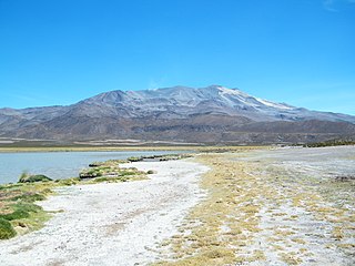
Salar del Huasco is a salt flat dotted with ponds and salt marshes, and seasonally partially covered with water, in northern Chile. It is the centerpiece of the recently created Salar del Huasco National Park and was designated Ramsar Site 874 on 2 December 1996. The area has a significant population of flamingos.
References
- ↑ Lictevout, Elizabeth; Abellanosa, Carlos; Maass, Constanza; Pérez, Nicolás; Gonzalo, Yáñez; Véronique, Leonardi Véronique (2020). "Exploration, mapping and characterization of filtration galleries of the Pica Oasis, northern Chile: A contribution to the knowledge of the Pica aquifer". Andean Geology . 47 (3): 529–558. doi: 10.5027/andgeoV47n3-3272 .
- 1 2 3 4 5 Bermúdez, Oscar (1980). "La población indígena de la doctrina de Pica. segunda mitad del s. XVIII". Chungara: Revista de Antropología Chilena (in Spanish). Universidad de Tarapacá. 6: 145–215.
20°21′49.32″S69°23′36.64″W / 20.3637000°S 69.3935111°W
| | This Tarapacá Region location article is a stub. You can help Wikipedia by expanding it. |