La Campana is an archaeological site included in the Mexican archaeological heritage list since 1917. Located in the vicinity of the city of Colima. This site was the largest prehispanic population center in western Mexico. Site studies indicate that some of its features are related to the classical period Teotihuacan culture.
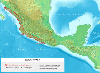
Vestiges of Capacha phase ceramics, dating from the year 1500 BCE were found onsite. This site features the presence of shaft tombs, ceramics offerings, storm drain systems, avenues and an administrative and religious center with numerous monuments. The site was opened to the public in 1995. The Spaniards discovered the place in 1524, at the time it was known as Almoloyan.m or “place between two rivers”.
Background
During prehispanic times, the region occupied by the modern-day state of Colima was seat of various ethnic groups which flourished in western Mexico. The region was inhabited by various Lordships (not reigns as erroneously stated by some historians) that disputed the territories. At the beginning of the 16th century, Purépecha groups dominated several regions, with the Tzacoalco salt mines owned by Tecos. Because of this, their leader Coliman or Tlatoani Colimotl defeated them. After the salt war, the Tecos took Sayula, Zapotlán and Amula and even reached Mazamitla, becoming the predominant group.[1]
Other sites known in the region:
Capacha Complex
Settlement of a sedentary Capacha Culture group dedicated to agriculture and ceramics production, their life span was between 2000 and 1000 BCE. The site is located 6 kilometres (3.7mi) north of Colima Municipality.[2]
Los Ortices Complex
Archaeologists assign a period between 300 BCE and 300 CE; located southwest of Colima, in the vicinity of the Los Ortices village. This native settlement was more evolved than the Capacha site, they produced finer pottery, also made stone sculpture and buried their dead in "shaft tombs", very characteristic of the region.[2]
Armería & Colima Complex
Chronologically placed between 600-1100 CE, in an area east of the Colima city, in the El Moralete neighborhood. This native group developed crafts with features somewhat more primitive than the others. Developed a smaller ceramics variety and built rougher shaft tombs.[2]
El Chanal Complex
El Chanal site developed the most representative style of the region, settled in the El Chanal community. In the mid-20th century a step pyramid was found; at the beginning of the 1990s, discovered esplanades, temples, squares and a ballgame court: architectural evidence of a culture that had reached a high degree of evolution. By 1520, this complex had already disappeared and only remained in the area some native peoples, apparently subjected to another more powerful city, Tecomán.[2]
History
The site originates in very early times, there are traces of Capacha Phase ceramics, from the early Mesoamerican Preclassical. Surface architectural evidence corresponds to the classical horizon (100-1500 CE) its maximum splendor was the period between 700 and 900 CE.[3]
It is important to note the presence of streets, a storm drainage system of and a religious and administrative center, with numerous monuments, as well as housing areas, areas with homes erected on platforms both circular and rectangular, with cane and adobe walls and palm ceilings, per the needs of a highly seismic region.[3]
The economy and development of La Campana was influenced by its geographical location in the Valley of Colima, because luxury goods, agricultural products, raw materials and other trade products converged here, from both the west coast and the center of Mexico Also it is considered that at its heyday exercised control over other smaller settlements. It is likely that, according to archaeologists, its decline was related to earthquakes that struck the ceremonial center, leaving only some groups up to 1521.
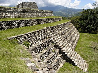
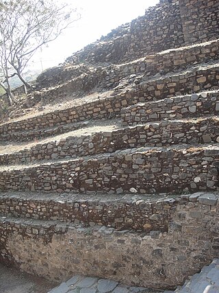
The site presents evidence of all prehispanic architectural development and the subsoil depicts equal architectural structure complexity. For building construction used stones of various sizes, from rivers, some of them very distant. To join the stones, and build the walls at various heights, they used clay mixed with vegetal fibers, the wall surfaces were covered with flattened stucco, which were subjected to fire in order to cure them and achieve the required quality.
Language
Much linguistic information was lost as a consequence of the Spanish conquest. Some researchers believe La Campana was a Nahuatl-speaking settlement, but it is thought residents also spoke other languages, some belonging to the Uto-Aztecan language family, which includes the following languages:
La Campana is only a portion of what was originally a very important prehispanic settlement, whose original name supposedly was Almoloya. A large religious and political-economic control center, but as in many other sites (e.g. Calixtlahuaca) in the 16th century Franciscan friars of the region used material extracted from the prehispanic platforms for their constructions. The first formal signs of the site existence were by Mr. José María Gutiérrez in 1917, he also made a drawing that included some structures. Dr. Miguel Galindo began exploring one of the buildings in 1922.[3]
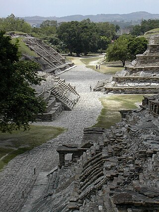
The archaeological site currently extends over 134 hectares between the Colima River and Pereira creek. To date, archaeologists have been able to explore barely 1% of the total area. Has an administrative ceremonial center, important center with numerous buildings; rectangular platforms of stepped of overlaid bodies, stepped pyramids that formed foundations for large temples and patios, in addition to other types of constructions. There are avenues and a large amount of petroglyphs in multiple patios and squares, in whose interior are structures of various dimensions. From the central point of the site towards the north is a 4 m wide avenue with side stone walls, defined communication element with other settlements, for example El Chanal locate about 3.5 kilometers northwest. Northwest of the site are housing units or early houses, and to the northeast a late section of the site, with a small ballgame court.[3]
The structures location and spatial distribution correspond to a planning and urban character lay out. The administrative-ceremonial center is impressive. It is formed by overlaid platforms with temples and residential constructions on top; and has a storm drainage system.
The constructive system, characteristic of the region included: "round stones" brought from nearby rivers, jointed with clay mortar and finished with fine stucco, subsequently heated (cooked) for hardness and durability. Rectangular and circular dwellings were probably distributed in housing groups, separated by cobbled streets. Had different dimensions and were roofed with palm and grass from the region. Recovered ceramic, although not abundant, probably due to looting suffered for decades, offers interesting data about this culture.
Multiple burials have been found during exploration, which provide new data on funeral customs and rites. It is noted that skeletons often lack hands and feet, as well as the rib cage.
La Campana, which was named by its casual discoverers by the appearance of the mound where it was found, is a place that holds evidence of Mexico western cultures. Its approximate dating is 900 BCE.
Description
La Campana archaeological site guide map.
La Campana section explored in the first season (1995) is located in a square with a network of decanting drainage wells to dislodge rainwater. It includes Structures 1 consisting of overlaid platforms, in the front, a stairway adorned with stone cubes, resembling a wall (alfarda). At the top is a large structure; inside has circles that define wells, probably used to stored grains and ashes of important people, perhaps priests or warriors killed in battle. In the center is a pyramid altar; its architectural features make it the only building erected on three stepped platforms, the sloped shape resembles the silhouette of the Fuego Volcano, which is assumed was an important cult object at the time. Human skeletal remains were located on both sides of the structure.
A third building, also erected on overlaid platforms, has two entrances that allow access to the top, has spaces defined by walls. It is believed their functions were related to private religious worship by priests who performed rituals there.
Buildings discovered in 1996 are on a huge square higher than the section found in 1995, built with stone and dirt materials over previously constructed buildings. This section presents two large platforms oriented east–west, on which there are a number of altars and small ceremonial rooms. Modest offerings were found in the rubble.
On the eastern side are two large pyramidal structures. The one in the middle only has three levels, the fourth was lost by a modern building at the top; it was built on a rectangular base 25 m per side, has a stairway at the center with side walls. Combines sloped walls with intermediate passages between the different bodies. On top was a compound or altar where priests probably performed rituals. This is deduced from the amount of offerings and artifacts found in the area.
The other building, has large slopped walls, part of the walls were found in 1996. Between both buildings, a ballgame court was built, with a narrow court, oriented east–west, with side slopped walls with a vertical section atop.
Important funeral rites elements were found, relating to prehispanic life after death interpretation. Several shaft tombs were found, with various offerings, domestic and ceremonial type, intended to accompany the deceased in their journey to the underworld.
This site, as well as many others in the region, have shaft tombs, one of these is near structure 6, Tomb No. 7, which besides in addition to the vault where various fragments of human bodies were buried, has a stepped corridor and major offerings that include a dog and clay mask.
Structure 1
Located south of the square, its rectangular base is 52 by 36 m; it is large and its construction is based on overlaid and stepped platforms. On top has a rectangular temple, inside has several circles. Access is by several broad stairs ornamented by four cubes. The steps have different heights: the first are significantly higher than the others.
After the site decline, worship continued, inferred by human skeletal remains found.
This structure was stuccoed, evidence of finished cooked clay covering the walls and floors of the building. It is possible that the stucco had decorative motifs, painted with mineral pigments from the region. Samples of the stucco can also be seen at the bottom of the eastern access to Structure 3. Particles of vegetal fibers can be seen mixed with adobe.
Structure 2
It is located at the square center, its base measures 20 by 20 m. Its shape depicts a volume and geometry arrangement, with a slender and unique silhouette. This building is a typical Colima architecture. It was built on three square and stepped platforms. Presents a beautiful slopped body with four staggered accesses; these lead to the top which is a square platform. Burials were found at its base.
Below grade drainage
Underground drainage.
Next to Structure 2 are some petroglyphs. In this area are parts of the underground drainage system, made to collect and evacuate storm rain water. It was originally covered with stones. Its lay out follows the buildings arrangement.
Structure 3
It is located northwest of the square, its base is 43 by 9 m; It is large and its construction is made with from overlaid stepped platforms similar to Structure 1. It has two entrances to the top; its elevation does not exceed 3 meters. There are holes at its base, probably to hold water or storage.
Structure 4
It is located southeast of the square and its base is 60 by 24 m; It is large and its construction is based on overlaid stepped platforms. It has 3 different accesses to the top and a significant elevation with a rainwater disposal system. Everything seems to indicate that this area were the homes of noble people.
Structure 4 has 11 medium size rooms, probably roofed with palm leaves supported by wooden columns.
It has communication to Structure 5, and in front of Structure 4 there is a small square, as well as a solar clock at the entrance of the Structure 5.
Structure 5
Square shape pyramidal building that dominates the urban complex, its base measures 26 by 31 m. It is a prehispanic monumental architecture building sample, evidence of the work, social desire, and artistic creativity of its constructors. The original Structure had several overlaid bodies, but currently only three are preserved. On the impressive basement top was a temple. Inside is another construction corresponding to an older building. Late changes are evident in the left side of the building.
Structure 6
This building is characterized by its enormous slopes and corridors that define different bodies; their shape and orientation obey Mesoamerican astronomical-religious and geometric concepts. At its top has large plazas, the lower section of the temple has stepped accesses and the place was probably used by priests for their rituals. Its orientation allowed observing the sun rise and sunset. It was used and modified by some late prehispanic groups. Its base measures 24 by 16 m.
Ballgame court
Located between Structures 5 & 6, it measures 16 by 8 m; space defined by a rectangular court, oriented on an east–west axis and delimited by two important lateral structures. This place was used to practice Tlalchi, ritual ballgame, with a symbolism associated with fertility and political-religious transcendence. Even after abandoned, the city continued to be a cult place.
Structure 11
Pyramidal temple, square base with four stepped accesses and measuring 24 by 9 m. Its orientation follows architectural principles based on geometrical shapes with astronomical elements and the symbolism associated to the cardinal points. On top was a small platform where political and religious ceremonies.
Two constructive stages were detected in this building. The first during the Classical period (100 BCE to 500 CE). Subsequently, modifications were made between 700 and 900 CE.
Structure 12
It consists of a platform significantly projected, because it defines the central square, and at the same time is a communication element with another square in the north. Rooms and temples were built on it. From evidence found, it is assumed that this platform had residential purposes for those engaged in religious worship.
Cascabel Pyramid
This structure has a rattle (Cascabel) snake sculpted in stone at the bottom of the access 1; it is symbolically related to the water cult. The snake was part of the water God (Tlaloc) representation and was associated with clouds, rain and lightning. Tlaloc was supposed to be a fire snake which passed through the region and when falling sank into the ground. Similar representations are found in temples of the Teotihuacan culture.
Gallery
Top row: Structures 1 to 4
Lower row: Structures 5 and 6, Ballgame court, Rattle Pyramid
El Tajín is a pre-Columbian archeological site in southern Mexico and is one of the largest and most important cities of the Classic era of Mesoamerica. A part of the Classic Veracruz culture, El Tajín flourished from 600 to 1200 CE and during this time numerous temples, palaces, ballcourts, and pyramids were built. From the time the city fell, in 1230, to 1785, no European seems to have known of its existence, until a government inspector chanced upon the Pyramid of the Niches.
Mixco Viejo, occasionally spelt Mixcu Viejo, is an archaeological site in the north east of the Chimaltenango department of Guatemala, some 50 kilometres (31 mi) to the north of Guatemala City and 4 kilometres (2.5 mi) from the junction of the rivers Pixcaya and Motagua. It is a moderate sized ruined city of the Postclassic Maya civilization.
Cantona is a Mesoamerican archaeological site in Mexico. It is located between 2,450 and 2,600 meters above sea level in the state of Puebla, on the border with the state of Veracruz. The site lies about an hour's drive from the city of Puebla and about an hour and a half from Xalapa, Veracruz. Limited archaeological work has been done at the site. It is estimated that only one to ten per cent of the site can be seen.
Cempoala or Zempoala is an important Mesoamerican archaeological site located in the Úrsulo Galván Municipality, in the state of Veracruz, Mexico. The site was inhabited mainly by Totonacs, Chinantecas and Zapotecs. It was one of the most important Totonac settlements during the postclassical Mesoamerican period and the capital of the kingdom of Totonacapan. It is located one kilometer from the shore of the Actopan River and six kilometres from the coast.
The Great Pyramid of Cholula, also known as Tlachihualtepetl, is a complex located in Cholula, Puebla, Mexico. It is the largest archaeological site of a pyramid (temple) in the New World, as well as the largest pyramid by volume known to exist in the world today. The adobe brick pyramid stands 25 metres (82 ft) above the surrounding plain, which is significantly shorter than the Great Pyramid of Giza's height of 146.6 metres (481 ft), but much wider, measuring 300 by 315 metres in its final form, compared to the Great Pyramid's base dimensions of 230.3 by 230.3 metres. The pyramid is a temple that traditionally has been viewed as having been dedicated to the god Quetzalcoatl. The architectural style of the building was linked closely to that of Teotihuacan in the Valley of Mexico, although influence from the Gulf Coast is evident as well, especially from El Tajín.
Maya architecture spans several thousands of years, several eras of political change, and architectural innovation before the Spanish colonization of the Americas. Often, the buildings most dramatic and easily recognizable as creations of the Maya peoples are the step pyramids of the Terminal Preclassic Maya period and beyond. Based in general Mesoamerican architectural traditions, the Maya utilized geometric proportions and intricate carving to build everything from simple houses to ornate temples. This article focuses on the more well-known pre-classic and classic examples of Maya architecture. The temples like the ones at Palenque, Tikal, and Uxmal represent a zenith of Maya art and architecture. Through the observation of numerous elements and stylistic distinctions, remnants of Maya architecture have become an important key to understanding their religious beliefs and culture as a whole.
La Quemada is an archeological site. It is located in the Villanueva Municipality, in the state of Zacatecas, about 56 km south of the city of Zacatecas on Fed 54 Zacatecas–Guadalajara, in Mexico.
Peralta is a prehispanic mesoamerican archaeological site located in Abasolo Municipality, Guanajuato, just outside the village of San Jose de Peralta in the Mexican state of Guanajuato. The site is reached via Fed 90 from Irapuato. Approximately 15.5 km south of the intersection with Fed 45, take the Irapuato-Huanimaro route southeast (left). Follow the route for about 12.5 km, then turnoff southwest (right) to San Jose de Peralta. Cross the bridge and turn right, and then follow the road out of the village northwest about 1 km. The site is on the left.
Plazuelas is a prehispanic archaeological site located just north of San Juan el Alto, some 2.7 kilometers (1.57 mi.) north of federal highway 90 (Pénjamo-Guadalajara), and about 11 kilometers (6.8 mi.) west of the city of Pénjamo in the state of Guanajuato, Mexico. The site is open to the public; it is dominated by a large, rectangular plaza with several pyramidal structures and platforms, along with a massive ball court. To the north of the structures is a field of boulders with thousands of glyphs carved into them.
Dainzú is a Zapotec archaeological site located in the eastern side of the Valles Centrales de Oaxaca, about 20 km south-east of the city of Oaxaca, Oaxaca State, Mexico. It is an ancient village near to and contemporary with Monte Albán and Mitla, with an earlier development. Dainzú was first occupied 700-600 BC but the main phase of occupation dates from about 200 BC to 350 AD. The site was excavated in 1965 by Mexican archaeologist Ignacio Bernal.
Castillo de Teayo is a mesoamerican Prehispanic archeological site and Mesoamerican pyramid, located in the La Huasteca region in northern Veracruz, Mexico. The main access to the site is via Federal Highway 130 México-Tuxpan up to the city of Teayo, it belongs to the Huastec culture and it is estimated it was inhabited between the 10th and 12th centuries.
Coatetelco or Cuatetelco is a pre-Hispanic archaeological site located next to the Coatetelco Lagoon, two kilometers from Alpuyeca, in the Miacatlán municipality, Morelos, Mexico, near Xochicalco. It had its greatest development between 500 and 150 BCE.
El Cerrito is an archaeological zone in the central Mexican state of Querétaro. It is located in the municipality of Corregidora on the outskirts of the state capital, Santiago de Querétaro.
El Chanal is an archaeological site located at El Chanal town, 4 kilometres (2.5 mi) north of the city of Colima, Mexico. Based on its extension, over 50 hectares, it is probable that it was the largest settlement of the state of Colima; it developed on both banks of the “Río Verde” or Río Colima. This archeological zone is maintained by the people of El Chanal. The area may have been inhabited by native groups around 1300 BC, achieving its maximum splendor between 1100 and 1400 CE. There is a Nahuatl connection shown by archaeological materials representing deities such as Tláloc and Ehécatl.
Capacha is an archaeological site located about 6 kilometers northeast of the Colima Municipality, in the Mexican state of Colima. This site is the heart of the ancient Mesoamerican Capacha Culture.
Huatusco is an archaeological site located in the Carrillo Puerto municipality, near the small, almost deserted town of Santiago Huatusco, on the northern bank of the Rio Atoyac in the Rancho El Fortin. The importance of the site due to the nearly undamaged pyramid from prehispanic times, the largest part of the actual temple is still standing, in the state of Veracruz, Mexico.
Ihuatzio is an archeological site in Michoacán state, Mexico. It is at the southern slopes of Cerro Tariaqueri, just north of the Ihuatzio town, in the Tzintzuntzan municipality.
San Miguel Ixtapan is an archaeological site located in the municipality of Tejupilco, in the State of Mexico.
Ixtlán del Rio is an archaeological site located in the Ixtlán del Rio municipality, on the south west region of the Mexican state of Nayarit. It is also known as "Los Toriles" and contains the only vestiges of the western cultures in Nayarit.
References
Braniff Cornejo, Beatriz. Introducción a la Arqueología del Occidente de México. INAH-Universidad de Colima, 2004. ISBN970-35-0297-0(in Spanish)
This page is based on this Wikipedia article Text is available under the CC BY-SA 4.0 license; additional terms may apply. Images, videos and audio are available under their respective licenses.